¶ Introduction
This OPMAN (OPeration MANual) presents all the air procedures and rules applicable in the airspace of Addis Abeba (HAAA FIR).
In addition, the airports of Bole Airport (HAAB) is detailed (IFR and VFR procedures).
This document is the responsibility of the HQ ATC department. For any questions/comments, you can contact them via the following e-mail address : a-srdep@ivao.aero
¶ History of modifications
| version | Modifications | Validation month |
|---|---|---|
| HAAA_01 | 2309 : Document creation | 09/2023 |
¶ Documentary organization
The OPMAN is divided into 4 parts :
- General rules and procedures (GEN),
This section will address national regulations and requirements, applicable units of measure, and services.
- En-route (ENR),
This section will cover ATS airspace, ATS routes, navigation aids and systems, and navigation hazards (P, R, D zones, ...).
- Aerodromes (AD).
This section will discuss aerodromes and heliports.
- Annex 1 (separate document) Quick Handled Memo of the FIR.
- Annex 2 (separate document) FRA restrictions inside the FIR.
- Annex 3 (separate document) List all the LoA concerning the FIR.
¶ GENERAL RULES AND PROCEDURES (GEN)
¶ Visual flight rules
Except for the case of special VFR; VFR flights will be conducted under the conditions detailed below :
- ceiling above 450m (1 500ft),
- visibility of more than 8km above 10 000ft AMSL, or 5km else.
Unless authorized by ATS, VFR flights will only be conducted below FL145.
Except for operational purposes (take-off, landing), no VFR flights will be conducted below 300m (1 000ft) of height from heavily populated areas ; within a radius of 600m.
Except for these areas, the overflight height must be 150m (500ft) above the ground, or ocean.
Unless otherwise authorized, the sending of a flight plan is mandatory. All boxes (1 to 18) must be completed.
¶ Instrument flight rules
An aircraft in IFR flight in the cruise phase within controlled airspace will use a cruise level. See Appendix 3 of ICAO Annex 2.
Aircraft in IFR flight, entering a control area to land, will be cleared to the specified holding point. They will receive instructions from the approach controller (time, level, next position). These instructions must be respected. Otherwise, the waiting procedure will be executed.
IFR departures from an uncontrolled aerodrome must contact the Area Control Center.
The Transition Altitude of Addis Abeba FIR depend on the airport, but no transition altitude is below 1 500ft (450m).
An IFR flight plan must be sent and completed.
¶ ATS airspace classification
ATS airspaces are classified and designated as detailed in ICAO Annex 11, Chapter 2.6. No specific rules are complementary.
IVAO Documentation about this : https://wiki.ivao.aero/en/home/training/documentation/Airspace_classification
¶ Rules of the air
It is forbidden to fly over towns, congested areas of cities, settlements or an open-air assembly of persons at less than 1 000 ft, except for take-off and landing.
Primary radars are unable to detect the altitude and speed of an aircraft.
The information given by the AURORA software is only a complementary tool to know the exact position of the aircraft. ATC manages the flow of traffic thanks to the pilots' position report (procedural control).
¶ Position report
Position reports will be made on route, when over, or as soon as possible, after passing designated reporting point. Additional reports may be requested by ATC.
Position report shall contain :
a) Aircraft identification
b) Position
c) Time
d) Flight level or altitude
e) Next position and time over
f) Ensuing significant point
¶ Unit of measurement
| For measurement of | Unit used |
|---|---|
| Distance used in navigation, position reporting, etc - generally in excess of 2 NM | *Nautical Miles and tenths |
| Relatively short distances such as those relating to aerodromes (e.g., runway lengths) | Meters |
| Altitudes, elevations and heights | Feet/Meters |
| Horizontal speed including wind speed | Knots/km/h |
| Vertical speed | Feet per minute |
| Wind direction for landing and taking off | Degrees Magnetic |
| Wind direction except for landing and taking off | Degrees True |
| Visibility, incl. runway visual range | Kilometers or meters |
| Altimeter setting | Hectopascal |
| Temperature | Degrees Celsius (Centigrade) |
| Weight | Metric tons or Kilograms |
| Time | Hours and minutes, the day of 24 hours beginning at midnight UTC |
| Notes:*One (1) international nautical mile = 1,852 Meters +Cruising levels are given in flight level numbers and not in altitudes | |
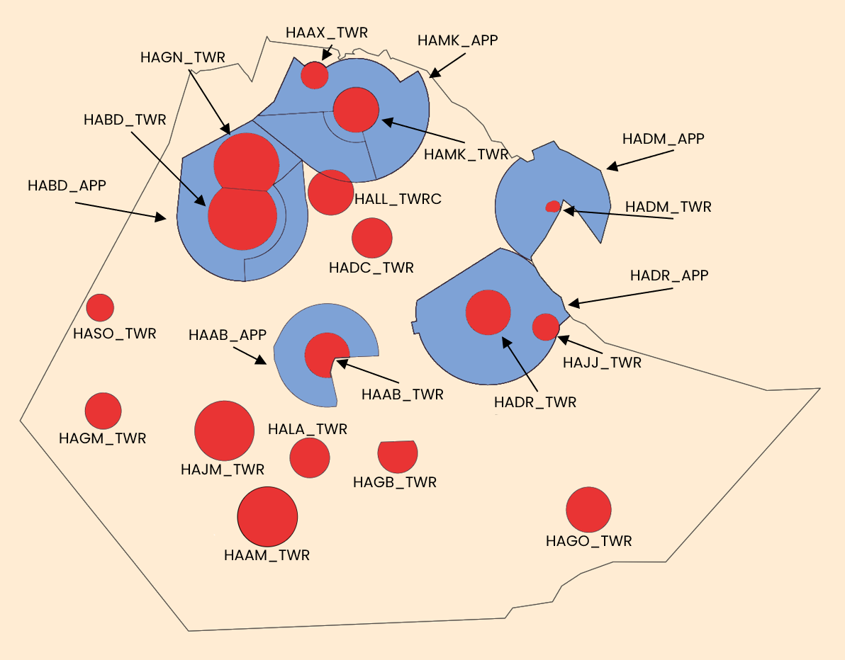
See below the ATC frequencies and the different airspace classes.
¶ Vertical sectorizations, CTR, CTA and TMA
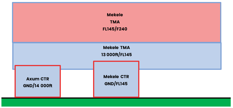
| Name (Languages) | Verticals limits | Areas and conditions | Callsign and Frequencies |
|---|---|---|---|
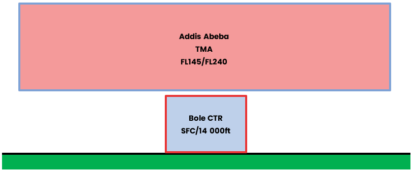
| Addis Abeba TMA (English) |
FL145/FL240 | TMA A airspace |
Bole Approach HAAB_APP 119.700 MHz |
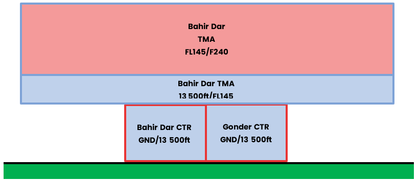
| Bahir Dar TMA (English) |
FL160/FL240 | TMA A airspace |
Bahir Dar Tower HABD_TWR 118.300 MHz |
| FL145/FL240 | TMA A airspace |
||
| 13 500ft/FL145 | TMA C airspace |
||
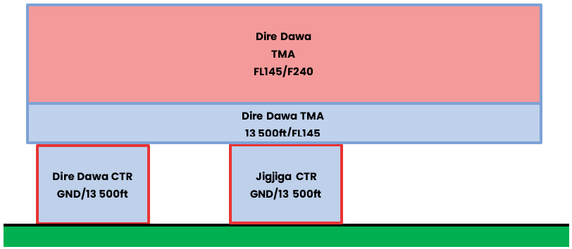
| Dire Dawa TMA (English) |
FL145/FL240 | TMA A airspace |
Dire Dawa Approach HADR_APP 120.300 MHz |
| 13 500ft/FL145 | TMA C airspace |
||
| Djibouti TMA (English) |
FL145/FL245 | TMA A airspace |
Djibouti Approach HADM_APP 121.100 MHz |
| 13 500ft/FL145 | TMA C airspace |
||
| Mekele TMA (English) |
FL170/FL240 | TMA A airspace |
Mekele Tower HAMK_TWR 118.100 MHz |
| FL145/F245 | TMA C airspace |
||
| 13 500ft/FL145 | TMA C airspace |
||
| Bole CTR (English) |
GND/14 000ft | CTR C airspace |
Bole Tower HAAB_TWR 118.100 MHz |
| Abra Minch CTR (English) |
GND/FL140 | CTR C airspace |
Abra Minch Tower HAAM_TWR 118.600 MHz |
| Asosa CTR (English) |
GND/10 000ft | CTR D airspace |
Asosa Tower HASO_TWR 118.500 MHz |
| Axum CTR (English) |
GND/FL140 | CTR C airspace |
Axum Tower HAAX_TWR 118.700 MHz |
| Bahir Dar CTR (English) |
GND/13 500ft | CTR C airspace |
Bole Tower HABD_TWR 118.300 MHz |
| Combolcha CTR (English) |
GND/11 500ft | CTR D airspace |
Combolcha Tower HADC_TWR 118.900 MHz |
| Dire Dawa CTR (English) |
GND/13 500ft | CTR C airspace |
Combolcha Tower HADR_TWR 118.300 MHz |
| Djibouti CTR (English) |
GND/1 800ft | CTR D airspace |
Djibouti Tower HADM_TWR 122.100 MHz |
| Gambella CTR (English) |
GND/FL140 | CTR C airspace |
Gambella Tower HAGM_TWR 118.700 MHz |
| Goba CTR (English) |
GND/13 500ft | CTR D airspace |
Goba Tower HAGB_TWR 118.700 MHz |
| Gode CTR (English) |
GND/10 000ft | CTR D airspace |
Combolcha Tower HAGO_TWR 118.600 MHz |
| Gonder CTR (English) |
GND/13 500ft | CTR C airspace |
Gonder Tower HAGN_TWR 118.600 MHz |
| Hawasa CTR (English) |
GND/12 400ft | CTR C airspace |
Hawassa Tower HALA_TWR 118.700 MHz |
| JigJiga CTR (English) |
GND/13 500ft | CTR C airspace |
JigJiga Tower HAJJ_TWR 118.500 MHz |
| Jimma CTR (English) |
GND/FL140 | CTR C airspace |
Jimma Tower HAJM_TWR 118.400 MHz |
| Lalibella CTR (English) |
GND/14 000ft | CTR C airspace |
Lalibella Tower HALL_TWR 118.500 MHz |
| Mekele CTR (English) |
GND/FL145 | CTR C airspace |
Mekele Tower HAMK_TWR 118.800 MHz |
¶ Addis Abeba
¶ Djibouti

¶ Dire Dawa
¶ Bahir Dar
¶ Mekele
¶ Horizontal sectorizations, FIR and UIR
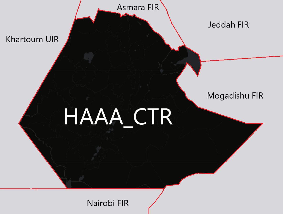
Below, the sectors adjacent to the FIR of Addis Abeba.
| Name (Languages) | Callsign | Frequencies |
|---|---|---|
| Addis Abeba FIR (English) | HAAA_CTR (Addis Abeba Center) | 125.100 MHz |
| Khartoum FIR (English) | HSSS_CTR (Khartoum Center) | 127.500 MHz |
| Nairobi FIR (English) | HKNA_CTR (Nairobi Center) | 121.300 MHz |
| Mogadishu FIR (English) | HSCM_FSS (Mogadishu Information) | 126.900 MHz |
| Mogadishu FIR (English) | HSCM_CTR (Mogadishu Control) | 132.500 MHz |
| Jeddah FIR (English) | OYSC_CTR (Sana'a Center) | 132.200 MHz |
| Asmara FIR (English) | HHAA_CTR (Asmara Center) | 120.700 MHz |
According to the previous table, here is the representation of the FIR airspace of Name.
¶ Vertical sectorizations, FIR and UIR
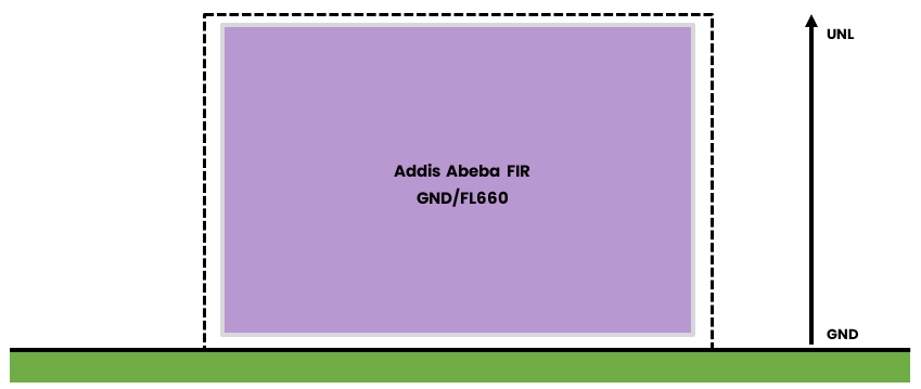
| Name (Languages) | Verticals limits | Areas and conditions | Callsign and Frequencies |
|---|---|---|---|
| Addis Abeba FIR (English) |
GND/FL660 | FIR G Airspace* |
Addis Abeba Center HAAA_CTR 125.100 MHz |
*Outside ATS routes, UTA TMAs, and CTRs.
¶ ATS Route
¶ Lower/Upper ATS routes
This section details the routes in the lower airspace.
| Designation of the route | Level | Route designation (FIX)* | Observation |
|---|---|---|---|
| A727 – UA727 | Odd/Even | ANTAX ⇆ AVONO | / |
| B403 - UB403 | MUSBI ⇆ MAV | ||
| B535 - UB535 | DAGAP ⇆ TORBA | ||
| B736 - UB736 | AVONO ⇆ GWZ | ||
| G300 - UG300 | TIKAT ⇆ MAV | ||
| G651 - UG651 | MURAL ⇆ KUSUB | ||
| G657 - UG657 | ASKEN ⇆ MAV | ||
| L432 - UL432 | EKBUL ⇆ GWZ | ||
| M216 - UM216 | AXAPO ⇆ RUDOL | ||
| M220 - UM220 | AVAGI ⇆ AXOTI | ||
| M308 - UM308 | RUDOL ⇆ KONET | ||
| M997 - UM997 | ASTAR ⇆ AVEDI | ||
| N301 - UN301 | GWZ ⇆ TIKAT | ||
| N304 - UN304 | DWA ⇆ AVUSI | ||
| Q554 - UQ554 | DWA ⇆ MVA | ||
| Q555 - UQ555 | AVONO ⇆ MAV | ||
| R775 - R775 | ALNAB ⇆ SOLUL | ||
| T225 - UT225 | BDR ⇆ GESEL | ||
| T226 - UT226 | GERIG ⇆ BDR | ||
| T226 - UT226 | GERIG ⇆ GESEL | ||
| T228 - UT228 | TIKAT ⇆ QHA | ||
| T229 - UT229 | GESEL ⇆ ETBUN | ||
| T333 - UT333 | GESEL ⇆ IMKUM | ||
| T334 - UT334 | GERIG ⇆ ETBUN | ||
| T335 - UT335 | TIMAG ⇆ ETBUN | ||
| T336 - UT336 | IMKUM ⇆ ETBUN | ||
| T337 - UT337 | GERIG ⇆ QHA | ||
| T338 - UT338 | GERIG ⇆ TIMAG | ||
| T444 - UT444 | TIMAG ⇆ QHA | ||
| T445 - UT445 | IMKUM ⇆ QHA | ||
| T446 - UT446 | BDR ⇆ GWZ | ||
| T447 - UT447 | GWZ ⇆ ERDIR | ||
| T448 - UT448 | BDR ⇆ ETBUN | ||
| T449 - UT449 | GWZ ⇆ DUKRI | ||
| T500 - UT500 | DUKRI ⇆ ERDIR | ||
| T666 - UT666 | TIKAT ⇆ BDR | ||
| T667 - UT667 | BRO ⇆ DWA | ||
| W885 - UW885 | DWA ⇆ HARGA | ||
| Y248 - UY248 | AXOTI ⇆ ETOKO |
- This column informs only the two points at the ends of the route.
¶ Radio navigation aids/systems en-route
| Name of station | ID | Frequency | Coordinates | Remarks |
|---|---|---|---|---|
| Addis Abeba VOR/DME |
ADS | 112.900 MHz | 08°58’30’’N 038°47’57’’E |
Coverage : 63NM at FL115 but unreliable beyond 20NM, at altitude of 12 500 ft and below from 280°-040° radials |
| Bahir Dar VOR/DME |
BDR | 114.400 MHz | 11°36’23”N 037°19’01” |
/ |
| Gambella VOR/DME |
BRO | 114.500 MHz | 08°07’41”N 034°33’41” |
Coverage : 150NM |
| Dire Dawa VOR/DME |
DWA | 117.700 MHz | 09°38’37”N 041°50’39” |
/ |
| Gawasa VOR/DME |
GWZ | 115.900 MHz | 09°06’22”N 038°46’11” |
Coverage : 200NM |
| Mekele CVOR/DME |
QHA | 116.600 MHz (CH 113X) | 13°28’21”N 039°31’29” |
Coverage : 100NM |
| Addis Abeba NDB |
AB | 333 kHz | 08°59’50”N 038°51’45” |
Coverage : 150NM |
| Arba Minch NDB |
AM | 275 kHz | 06°03’27”N 037°36’08” |
Coverage : 150NM |
| Axum NDB |
AX | 440 kHz | 14°08’45”N 038°46’34” |
Coverage : 150NM |
| Dire Dawa NDB |
AY | 241 kHz | 09°38’37”N 041°50’38” |
/ |
| Gonder NDB |
AZZ | 349 kHz | 12°29’53”N 037°26’16” |
Coverage : 50NM |
| Addis Abeba NDB |
BL | 352 kHz | 08°59’05”N 038°49’12” |
Coverage : 150NM |
| Debre Markos NDB |
DM | 235 kHz | 10°12’31”N 037°45’04” |
Coverage : 150NM |
| Gode NDB |
GO | 382 kHz | 05°55'53"N 043°34'17"E |
Coverage : 150NM |
| Jimma NDB |
JM | 263 kHz | 07°40'07"N 036°49'17"E |
Coverage : 100NM |
| Lake Awasa NDB |
LA | 215 kHz | 07°04'00"N 038°30'00"E |
Coverage : 200NM |
| Lalibela NDB |
LLB | 390 kHz | 11°58'41"N 038°59'00"E |
Coverage : 100NM |
| Mekele NDB |
MK | 256 kHz | 11°28'30"N 039°31'18"E |
Coverage : 100NM |
| Mekele NDB |
MK | 256 kHz | 11°28'30"N 039°31'18"E |
Coverage : 100NM |
| Bahir Dar NDB |
TN | 420 kHz | 11°35'29"N 037°18'17"E |
/ |
¶ Navigation wanings
¶ Prohibited areas
| Identification | Lower/Upper limits | Remarks | ||
|---|---|---|---|---|
| HA(P) - 1 (PROHIBITED) | Ground | UNL | Large Ethiopian dam. | |
¶ Restricted areas
| Identification | Lower/Upper limits | Remarks | ||
|---|---|---|---|---|
| HA(R) - 1 (RESTRICTED) | Ground | FL290 | Military operations. | |
| HA(R) - 2 (RESTRICTED) | Ground | FL290 | Military operations. | |
| HA(R) - 3 (RESTRICTED) | Ground | FL310 | Large Ethiopian dam | |
| HD(R) - 4 RAS BIR (RESTRICTED) | Ground | FL200 | Firings heavy weapons. | |
| HD(R) - 7 GODORIA (RESTRICTED) | Ground | FL240 | Firings heavy weapons. | |
¶ Danger areas
| Identification | Lower/Upper limits | Remarks | ||
|---|---|---|---|---|
| HD(D) - 1 MYRIAM (DANGER) | Ground | FL240 | Firings heavy weapons. | |
| HD(D) - 5 ARTA (DANGER) | Ground | 2 700ft AMSL | Firings small weapons. | |
| HD(D) - 8 GONLEY (DANGER) | Ground | 4 000ft AMSL | Firings small weapons. | |
| HD(D) - 9 ALI SABIEH (DANGER) | Ground | 5 000ft AMSL | Firings small weapons. | |
| HD(D) - 10 HOL HOL (DANGER) | Ground | 3 000ft AMSL | Firings small weapons. | |
| HD(D) - 11 DIK HIL (DANGER) | Ground | 3 000ft AMSL | Firings small weapons. | |
| HD(D) - 12 YOBOKI (DANGER) | Ground | 3 00ft AMSL | Firings small weapons. | |
| HD(D) - 13 TADJOURAH (DANGER) | Ground | 3 000ft AMSL | Firings small weapons. | |
| HD(D) - 14 OBOCK (DANGER) | Ground | 3 000ft AMSL | Firings small weapons. | |
| HD(D) - 15 RAMI (DANGER) | Ground | FL240 | Firings small Air-Ground. | |
| HD(D) - 16 GAHERRE (DANGER) | Ground | 3 000ft AMSL | Firings small weapons. | |
¶ Specials areas
| Identification | Lower/Upper limits | Remarks | ||
|---|---|---|---|---|
| KATERIN Zone (TSA) | Ground | FL140 | Parachute jumping area. | |
¶ AERODROMES (AD)
¶ Addis Ababa/Bole International Airport – HAAB
¶ Airport Information
| Informations | |
|---|---|
| ICAO Code | HAAB |
| IATA Code | ADD |
| Airport name | Addis Ababa/Bole International (Ethipia) |
| Time zone conversion | UTC + 3 |
| Coordinates of the reference point and location of the airfield | 08° 58’ 30.14 N 038° 47’ 57.83 E |
| Direction and distance from (city) | 147° / 8km (4.3nm) of Addis Ababa City Hall |
| Altitude / temperature reference | 2333.5m (7655 feet) / 25°C |
| Magnetic declination | 2° W |
| Permitted traffic types | IFR / VFR |
| Runway | 07L/25R - 07R/25L |
¶ Characteristic of the runway
The runway 07L/25R - 07R/25L has the following features:
| Description of the runway | Runway 07L | Runway 25R | Runway 07R | Runway 25L |
|---|---|---|---|---|
| Dimensions of runway (m) | 3700 x 45 | 3700 x 45 | 3800 x 45 | 3800 x 45 |
| True and Mag Brg | 074° True / 72° Mag | 254 True / 252° Mag | 074° True / 72° Mag | 254 True / 252° Mag |
| Strength (PCN) and surface of runway | 65/F/D/X/T asphalt concert | 65/F/D/X/T asphalt concert | 100 /F/D/X/T asphalt concert | 100 /F/D/X/T asphalt concert |
| Threshold coordinates | 08°58’28.60 S 038°47’04.47 E | 08°58’56.82 S 038°48’41.29 E | 08°58’23.65 S 038°47’11.91 E | 08°58’51.85 S 038°48’48.71 E |
| Threshold elevation | Threshold 2322m (7621ft) | Threshold 2308m (7573ft) | Threshold 2321m (7617ft) | Threshold 0m (7596ft) |
| TORA (m) | 3700 | 3700 | 3800 | 3800 |
| TODA (m) | 3760 | 3760 | 3890 | 3890 |
| ASDA (m) | 3760 | 3760 | 3800 | 3800 |
| LDA (m) | 3375 | 3325 | 3440 | 3440 |
¶ ATS Communication facilities
| Designation service | Callsign | Frequency |
|---|---|---|
| Center | Addis Abeba Center (HAAA_CTR) | 125.100 MHz |
| Approach | Bole Approach (HAAB_APP) | 119.700 MHz |
| Tower | Bole Tower (HAAB_TWR) | 118.100 MHz |
| Ground | Bole Ground (HAAB_TWR) | 121.900 MHz |
¶ Radio navigation and landing aids
| Type of aid | Callsign | Frequency | Informations |
|---|---|---|---|
| VOR/DME | ADS | 112.900 MHz | 08°58’30’’N 038°47’57’’E |
| VOR/DME | GWZ | 115.900 MHz | 09°06’22”N 038°46’11” |
| NDB | AB | 333 kHz | 08°59’50”N 038°51’45” |
| NDB | BL | 352 kHz | 08°59’05”N 038°49’12” |
| ILS/LLZ | IAA | 111.500 MHz | 08°58’16"S 038°46’47"E |
¶ Local airports regulation
¶ Automatic Terminal Information Service
The ATIS must be completed in English
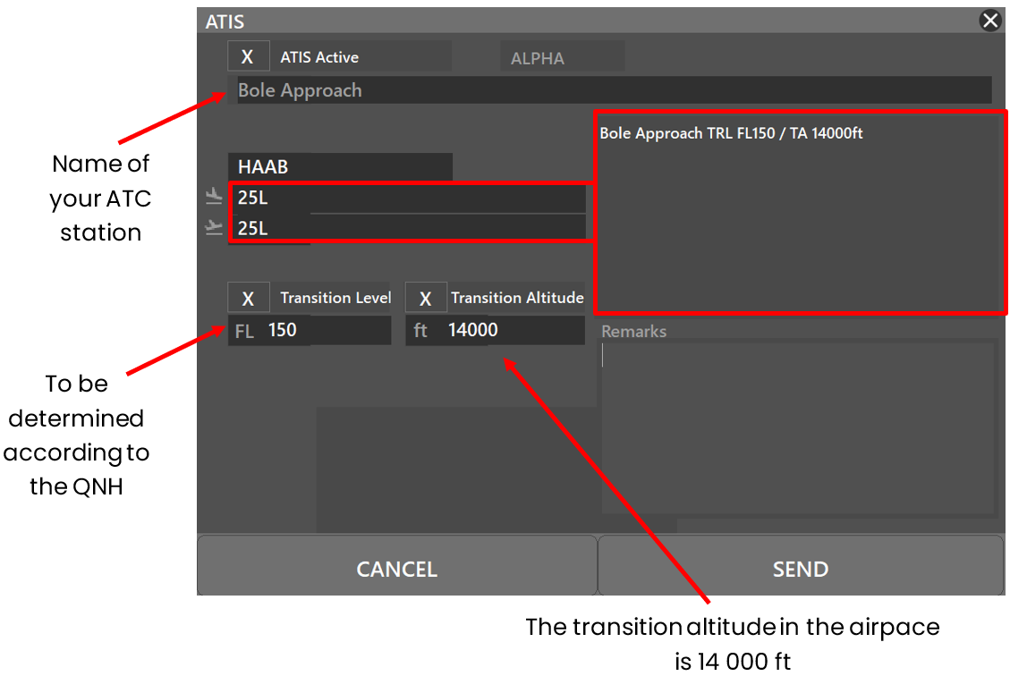
At the beginning of the session, please fill out the ATIS correctly. The transition
altitude (TA) is 14 000ft. The transition level (TL) is to be determined according
to the QNH. The first usable level is FL150.
The preferential runway is the 07R/25l, an ILS procedure is available on
runway 25L. Any special information can be marked in the "remarks" box.
| ATIS station | Frequency |
|---|---|
| Addis Abeba Airport | 125.800 MHZ |
¶ Traffic areas
The tower will assign a gate number to arriving aircraft. General aviation aircraft will be required to use their designated apron area.
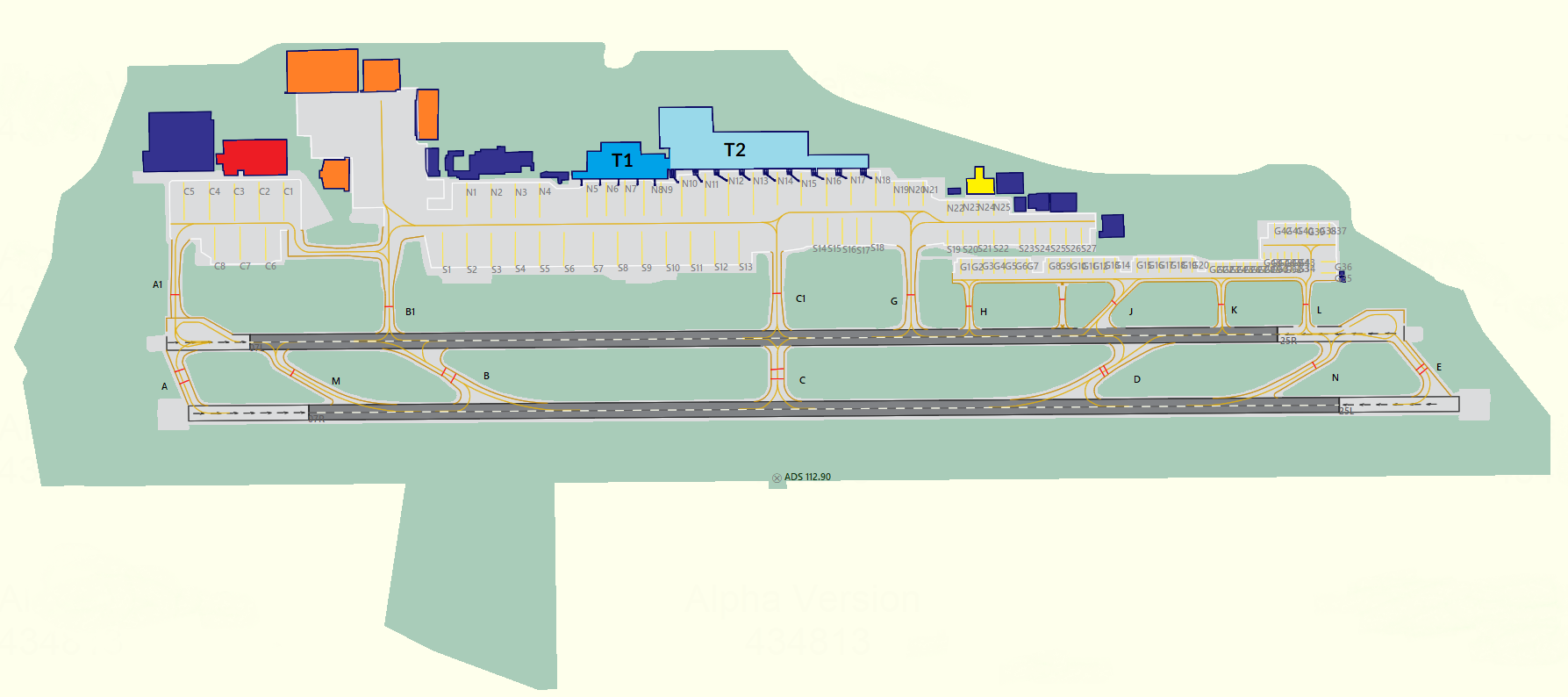
T1 is used for domestic operations. Ethiopian airlines´ turboprop fleet are usually parked on remote stands, N1 …. N4 and S1…S13.
T2 is used for International flights.
The building coloured yellow, just north of stands N22 to N25 is the VIP. Terminal.
Orange buildings represent maintenance hangars.
G1….G48 and the eastern apron where they are located, are used by General Aviation.
Cargo Apron is the westernmost one with the red building.
¶ Aircraft gate management
Located in front of the terminal 1 and 2, the commercial aviation parking lot has 16 parking spaces for the different categories (see below).
| Bay | Airlines | Aircraft types |
|---|---|---|
| C1 - C6 | Ethiopian Cargo | B738 - B763 - B77L |
| G1 - G20 | Storage | All |
| G21 - G48 | Storage and General Aviation | All |
| N1 - N4 | Ethiopian Airlines | DH8D |
| N5 - N9 | Ethiopian Airlines | B38M - DH8D |
| N10 - N21 | Ethiopian Airlines - Fly Dubai - Emirates - Turkish Airlines - Qatar Airways | B77W - B789 - A35X - B738 - A333 |
| N22 - N25 | Private Aircraft | B38M - DH8D |
| S1 - S13 | Ethiopian Airlines | DH8D |
| S14 - S27 | Storage | All |
¶ Squawk code
For better traffic management in the Addis Abeba airspace, here are the squawk codes to assign to traffic according to their destination.
| Flight | Code |
|---|---|
| International | 2400 - 2477 |
| Domestic | 1300 - 1377 |
Please note that SSR equipement are only available inside the Addis Abeba TMA, outise, position report are mandatory for IFR and VFR within the Addis Abeba FIR, pilots shall report their position as specified in 3.6.3 of ICAO Annex 2 for controlled flight.
¶ Characteristics of the taxiways
Please find bellow the different taxiway :
| Taxiways description | Traffic taxiways | ||
|---|---|---|---|
| Taxiway witdh (m) | Geographical coordinates of the appropriate axial points of the taxiways | ||
| A | 27 | 08°58’23 S - 038°46’58 E | |
| A1 | 30 | 08°58’31 S - 038°46’56 E | |
| B | 26 | 08°58’30 S - 038°47’24 E | |
| B1 | 25 | 08°58’35 S - 038°47’16 E | |
| C | 39 | 08°58’31 S - 038°46’56 E | |
| C1 | 25 | 08°58’47 S - 038°47’52 E | |
| D | 31 | 08°58’48 S - 038°48’25 E | |
| E | 31 | 08°58’57 S - 038°48’55 E | |
| G | 23 | 08°58’50 S - 038°48’05 E | |
| H | 18 | 08°58’51 S - 038°48’11 E | |
| J | 20 | 08°58’55 S - 038°48’24 E | |
| K | 18 | 08°58’58 S - 038°48’34 E | |
| L | 18 | 08°59’00 S - 038°48’42 E | |
| M | 21 | 08°58’29 S - 038°47’08 E | |
| N | 23 | 08°58’54 S - 038°48’45 E | |
¶ CTR description
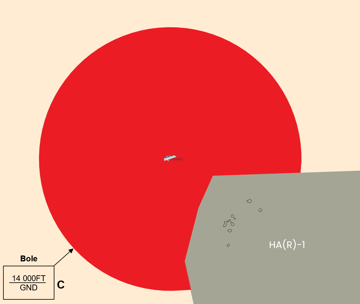
Bole airport has a class C CTR, starting from the surface, and going up to 14 000ft AMSL. There is on P area are located inside the CTR, and the aerodrome traffic circuit is not published.
¶ VFR entries, exits, transits in CTR
CTR entries, exits and transits are not published. VFR transits will pass vertically from the airport at least 500ft above the presume aerodrome traffic patterns altitude (1000ft AGL).
¶ TMA area description
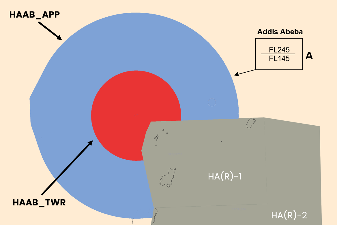
The control sector of Addis Abeba represents one TMA. The responsible ATC station is Bole approach.
¶ Prohibited areas
There is no prohibited areas within the TMA of Addis Abeba
¶ Restricted areas
There is no restricted areas within the TMA of Addis Abeba
¶ Danger areas
There is no danger areas within the TMA of Addis Abeba
¶ Departures and Arrivals
Please refer to the ATC Briefing here : Addis Abeba ATC Briefing