¶ Introduction
This OPMAN (OPeration MANual) presents all the air procedures and rules applicable in the airspace of Tallinn (EETT FIR).
In addition, the airports of Tallinn Airport (EETN) is detailed (IFR and VFR procedures).
This document is the responsibility of the HQ ATC department. For any questions/comments, you can contact them via the following e-mail address : a-srdep@ivao.aero
Link to the national eAIP : https://aim.eans.ee/et/eaip
¶ History of modifications
| Version | Modifications | VID | Validation month |
|---|---|---|---|
| EETT_01 | Document Creation 2311 | 610609 | 11/2023 |
¶ Documentary organization
The OPMAN is divided into 3 mains parts:
- General rules and procedures (GEN)
This section will address national regulations and requirements, applicable units of measure, and services.
- En-route (ENR)
This section will cover ATS airspace, ATS routes, navigation aids and systems, and navigation hazards (P, R, D zones, ...).
- Aerodromes (AD)
This section will discuss aerodromes and heliports.
And three annexes :
- ANNEX 1 : Quick Handle Memo of the FIR
This annex will summaries all important information needed while controlling.
- ANNEX 2 : FRA restrictions inside the FIR and laterals limits
This annex while present every different position in the FIR and the FRA associated, and the laterals limits of airspaces
- ANNEX 3 : List all the LoA concerning the FIR
This annex will list all the LoA – if existing – in the FIR.
¶ GENERAL RULES AND PROCEDURES (GEN)
¶ Visual flight rules
Except for the case of special VFR; VFR flights will be conducted under the conditions detailed below :
- ceiling above 450m (1 500ft),
- visibility of more than 5km.
Unless authorized by ATS, VFR flights will only be conducted below FL195.
Except for operational purposes (take-off, landing), no VFR flights will be conducted below 300m (1 000ft) of height from heavily populated areas ; within a radius of 600m.
Except for these areas, the overflight height must be 150m (500ft) above the ground, or ocean.
Unless otherwise authorized, the sending of a flight plan is mandatory. All boxes (1 to 18) must be completed.
¶ Instrument flight rules
An aircraft in IFR flight in the cruise phase within controlled airspace will use a cruise level. See Appendix 3 of ICAO Annex 2.
Aircraft in IFR flight, entering a control area to land, will be cleared to the specified holding point. They will receive instructions from the approach controller (time, level, next position). These instructions must be respected. Otherwise, the waiting procedure will be executed.
IFR departures from an uncontrolled aerodrome must contact the Area Control Center.
The Transition Altitude of Tallinn FIR is 5 000 feet. The first usable flight level is FL060.
An IFR flight plan must be sent and completed.
¶ ATS airspace classification
ATS airspaces are classified and designated as detailed in ICAO Annex 11, Chapter 2.6. No specific rules are complementary.
¶ Rules of the air
Primary radars are unable to detect the altitude and speed of an aircraft.
The information given by the AURORA software is only a complementary tool to know the exact position of the aircraft. If no radar, ATC manages the flow of traffic thanks to the pilots' position report (procedural control).
Published Minimum (Radar) Vectoring Altitude allow air traffic management by "radar vectors". Heading can be provided to ensure safe obstacle clearance.
Tallinn FIR is equipped with Secondary Surveillance Radar (SSR) at the Tallinn and Parnu airports, coverage will be detailed later.
No CPDLC can be used inside the FIR, not equipped.
¶ Units used inside the FIR
| For measurement of | Unit used |
|---|---|
| Distance used in navigation, position reporting, etc - generally in excess of 2 NM | Nautical Miles (nm) and tenths |
| Relatively short distances such as those relating to aerodromes (e.g., runway lengths) | Meters (m) |
| Altitudes, elevations and heights | Feet (ft) |
| Horizontal speed including wind speed | Knots (kt) |
| Vertical speed | Feet per minutes (ft/min) |
| Wind direction for landing and taking off | Degrees Magnetic (°) |
| Wind direction except for landing and taking off | Degrees True (°) |
| Visibility, incl. runway visual range | Kilometers or meters (km or m) |
| Altimeter setting | Hectopascal (hPa) |
| Temperature | Degrees Celsius (°) |
| Weight | Metric tons or Kilograms (t or kg |
| Time | Hours (hr) and minutes (min); beginning at midnight UTC |
| Volume | Litre (L) |
¶ EN-ROUTE (ENR)
¶ ATS airspaces
¶ Horizontal sectorizations, CTR, CTA and TMA
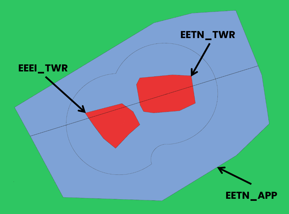
See below the ATC frequencies and the different airspace classes.
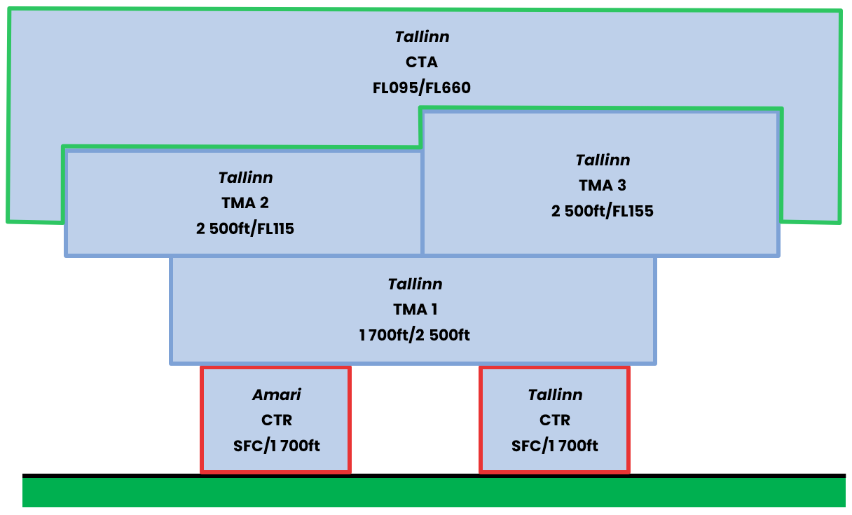
¶ Vertical sectorizations, CTR, CTA and TMA
| Name (Languages) |
Laterals limits | Verticals limits | Areas and conditions | Callsign and Frequencies |
|---|---|---|---|---|
| Tallinn TMA 1 (Estonian, English) |
See Annex 2 | 1 700ft/2500ft | TMA C Airspace |
Tallinn Radar EETN_CTR 127.905 MHz |
| Tallinn TMA 2 (Estonian, English) |
See Annex 2 | 2 500ft/FL115 | TMA C Airspace |
Tallinn Radar EETN_CTR 127.905 MHz |
| Tallinn TMA 3 (Estonian, English) |
See Annex 2 | 2 500ft/FL155 | TMA C Airspace |
Tallinn Radar EETN_CTR 127.905 MHz |
| Amari CTR (Estonian, English) |
See Annex 2 | SFC/1 700ft | TMA D Airspace |
Amari Tower EEEI_CTR 122.100 MHz |
| Tallinn CTR (Estonian, English) |
See Annex 2 | SFC/1 700ft | TMA D Airspace |
Tallinn Tower EETN_CTR 127.905 MHz |
¶ Horizontal sectorizations, FIR and UIR
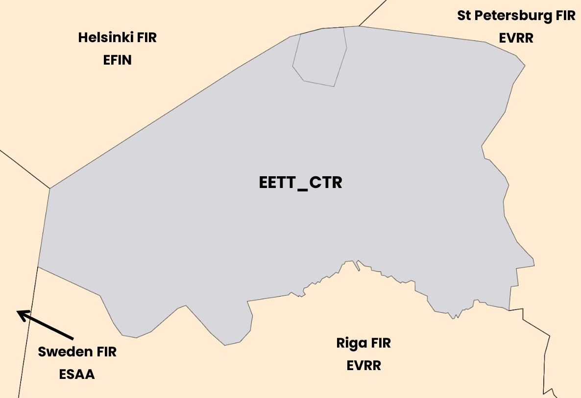
Below, the sectors adjacent to the FIR of Tallinn.
| Name (Languages) | Callsign | Frequencies |
|---|---|---|
| Tallinn FIR (Estonian, English) |
EETT_CTR (Tallinn Control) | 134.325 MHz |
| Helsinki FIR (Finnish, English) |
EFIN_CTR (Helsinki Control) | 132.325 MHz |
| Sweden FIR (English) |
ESAA_CTR (Sweden Control) | 124.430 MHz |
| Riga FIR (English) |
EVRR_CTR (Riga Control) | 133.200 MHz |
| Saint Peterburg FIR (Russian, English) |
ULLL_CTR (Petersburg Control) | 135.600 MHz |
According to the previous table, here is the representation of the FIR airspace of Tallinn.
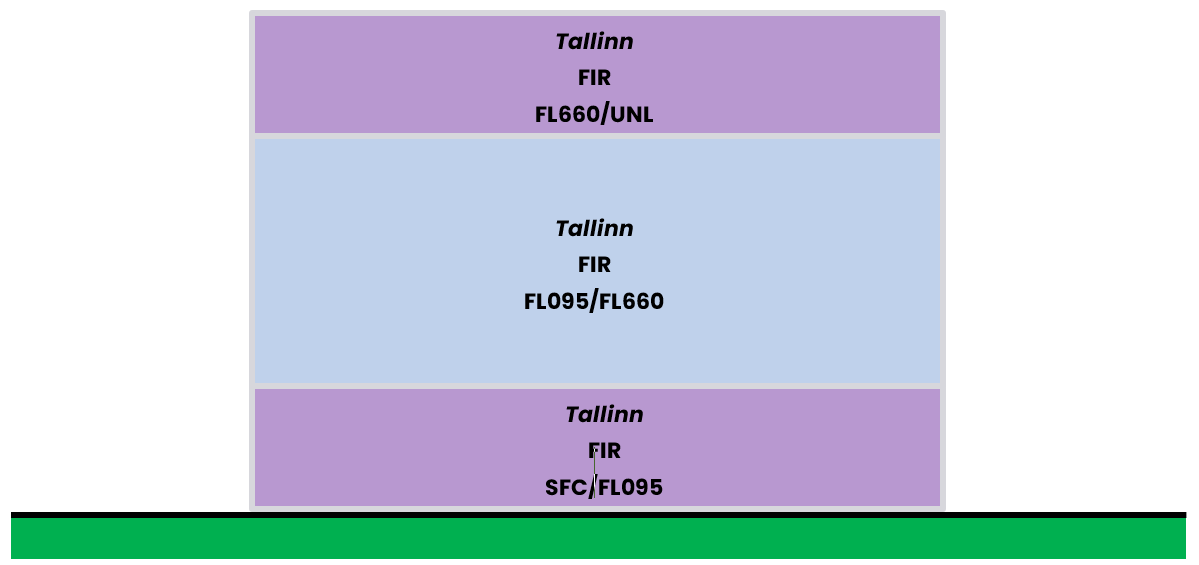
¶ Vertical sectorizations, FIR and UIR
| Name (Languages) |
Laterals limits | Verticals limits | Areas and conditions | Callsign and Frequencies |
|---|---|---|---|---|
| Tallinn FIR (Estonian, English) |
See Annex 2 | FL660/UNL | FIR G Airspace |
Tallinn Control EETT_CTR 134.325 MHz |
| Tallinn FIR (Estonian, English) |
See Annex 2 | FL095/FL660 | FIR C Airspace |
Tallinn Control EETT_CTR 134.325 MHz |
| Tallinn FIR (Estonian, English) |
See Annex 2 | SFC/FL095 | FIR G Airspace |
Tallinn Control EETT_CTR 134.325 MHz |
¶ ATS Route
¶ Upper/Lower ATS routes
This section details the routes in the upper and lower airspace.
| Designation of the route | Level | Route designation (FIX)* | Observation |
|---|---|---|---|
| L870 | Even | RANVA -> RESMO | FL660 - - - Class C - - - FL095 |
| N609 | Odd | SUMIM -> NOTAR | |
| P607 | Odd | TIXTE ⇆ NOTAR | |
| P863 | Even | RANVA -> LUKUN | |
| P989 | Odd | TUKMA -> MEGAS | |
| Q11 | Odd | KEMET ⇆ KEXLE | |
| Q11 | Even | KEXLE -> INTOR | |
| Q22 | Odd | SULUN -> KEXLE | |
| Q33 | Odd | LONSA -> INTOR | |
| Q55 | Odd | OSMUR -> SORPA | |
| Q77 | Odd | LARTI ⇆ GONOS | |
| Q92 | Even | IBUZU -> INTOR | |
| Q414 | Even | BIRSI -> INTOR | |
| T633 | Odd | NUMSU -> RISAT | |
| T635 | Odd | TITOV -> PIRUS | |
| T652 | Odd | PIMOM -> TALER | |
| T653 | Odd | MONUS -> DITEL | |
| Y117 | Even | VALOX -> ROSAX | |
| Y123 | Even | KOIVU -> LARTI | |
| Y168 | Odd | DOHOR -> NOTAR |
¶ Free Route Airspace
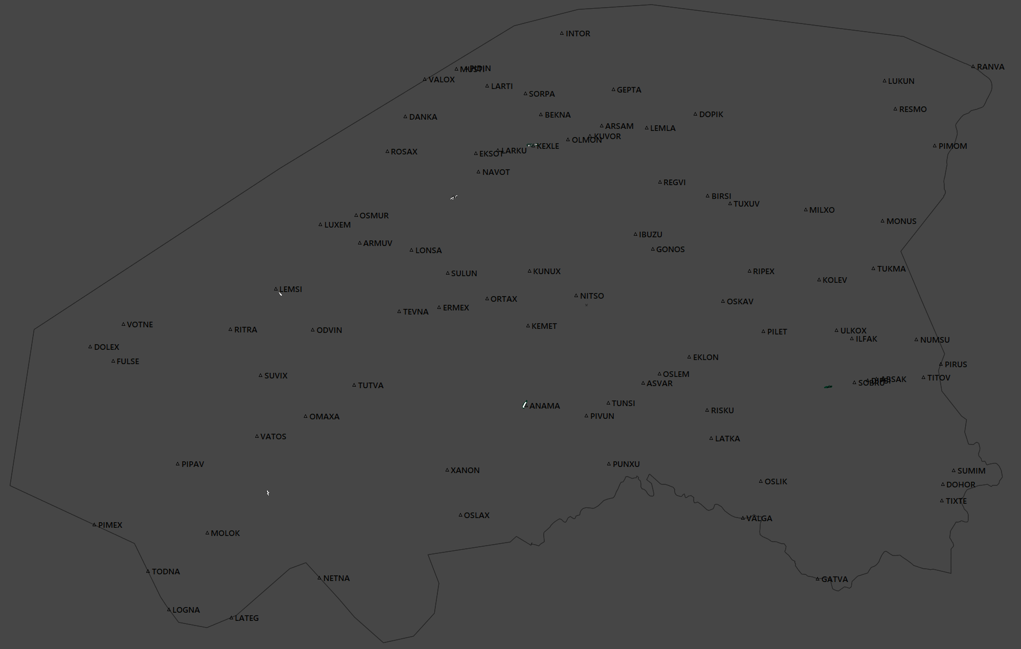
Between FL095 and FL660, the FIR of Tallinn is a FRA, so no airways required.
Here is the map of the waypoint inside the FRA, any direct can be assigned within the limite of the EETT FIR, according to traffic flow.
¶ Radio navigation aids/systems en-route
| Name of station | ID | Frequency | Coordinates | Remarks |
|---|---|---|---|---|
| Amari VOR - TACAN |
AMI | 115.300 MHz | 59°16'01"N 24°14'48"E |
/ |
| Kardla DME |
KRD | 117.600 MHz | 58°59'31"N 22°49'55"E |
/ |
| Kuressaare DME |
KRS | 112.400 MHz | 58°13'41"N 22°30'51"E |
Coverage : FL500/80 nm |
| Tallinn DME |
TLL | 112.200 MHz | 59°24'40"N 24°50'18"E |
Coverage : FL500/80 nm |
¶ Navigation warnings
¶ Restricted areas
| Identification | Lower/Upper limits | Remarks | ||
|---|---|---|---|---|
| EE(R) - 01 PIIRIALA | Ground | 1 000ft AMSL | Border Area. | |
| EE(R) - 03 VILSANDI | Ground | 3 500ft AMSL | National Park. | |
| EE(R) - 04 MATSALU | Ground | 3 500ft AMSL | ||
| EE(R) - 15D | Ground | FL095 | Military air operations. | |
| EE(R) - 15E | Ground | FL095 | ||
| EE(R) - 15F | Ground | FL095 | ||
| EE(R) - 15G | Ground | FL095 | ||
| EE(R) - 16E | 5 000ft AMSL | FL095 | ||
| EE(R) - 16W | 5 000ft AMSL | FL095 | ||
| EE(R) - 18 | 5 000ft AMSL | FL095 | ||
| EE(R) - 19 | Ground | 2 200ft AMSL | An object of the Ministry of Defense's jurisdiction. | |
| EE(R) - 20 | Ground | 2 200ft AMSL | ||
| EE(R) - 21 | Ground | 2 200ft AMSL | ||
| EE(R) - 22 | Ground | 2 200ft AMSL | ||
| EE(R) - 23 | Ground | 2 200ft AMSL | ||
| EE(R) - 24 | Ground | 2 200ft AMSL | ||
| EE(R) - 25 | Ground | 2 200ft AMSL | ||
| EE(R) - 26 | Ground | 2 200ft AMSL | ||
| EE(R) - 27 | Ground | 660ft AMSL | ||
| EE(R) - 28 | Ground | 660ft AMSL | ||
| EE(R) - 29 | Ground | 660ft AMSL | ||
| EE(R) - 30 | Ground | 660ft AMSL | ||
| EE(R) - 31 | Ground | 660ft AMSL | ||
| EE(R) - 32 | Ground | 660ft AMSL | ||
¶ Danger areas
| Identification | Lower/Upper limits | Remarks | ||
|---|---|---|---|---|
| EE(D) - 02 UNIKÜLA | Ground | 1 900ft AMSL | Gunfiring. | |
| EE(D) - 04 NURSIPALU 2 | Ground | 9 200ft AMSL | ||
| EE(D) - 05 KILTSI | Ground | 2 100ft AMSL | ||
| EE(D) - 06 PAHKLA | Ground | 2 300ft AMSL | ||
| EE(D) - 07 PIIRSALU | Ground | 2 200ft AMSL | ||
| EE(D) - 08 RUTJA | Ground | 2 200ft AMSL | ||
| EE(D) - 09 VÄLUSTE | Ground | 2 200ft AMSL | ||
| EE(D) - 10 UTSALI | Ground | 2 200ft AMSL | ||
| EE(D) - 11 METSNIKU | Ground | 2 300ft AMSL | ||
| EE(D) - 13 TAPA 1 | Ground | 2 400ft AMSL | ||
| EE(D) - 14 TAPA 2 | Ground | 14 700ft AMSL | ||
| EE(D) - 16 KLOOGA 1 | Ground | 2 100ft AMSL | Gunfiring and military air operations. | |
| EE(D) - 17 SIRGALA 2 | Ground | 15 400ft AMSL | Gunfiring. | |
| EE(D) - 18 TSIATSUNGÕLMAA | Ground | 2 400ft AMSL | ||
| EE(D) - 20 MÄNNIKU | Ground | 1 700ft AMSL | ||
| EE(D) - 23 NAISSAAR | Ground | 4 000ft AMSL | ||
| EE(D) - 25 MURU | Ground | 2 200ft AMSL | ||
| EE(D) - 26 VIRU | Ground | 1 700ft AMSL | ||
| EE(D) - 27 KARUJÄRVE | Ground | 2 200ft AMSL | ||
| EE(D) - 29 KAPASTU | Ground | 2 200ft AMSL | ||
| EE(D) - 31 KOGUVA | Ground | 2 200ft AMSL | ||
| EE(D) - 32 KIKEPERA | Ground | 2 200ft AMSL | ||
| EE(D) - 33 LAURI | Ground | 2 200ft AMSL | ||
| EE(D) - 34 LILLI | Ground | 2 200ft AMSL | ||
| EE(D) - 35G | Ground | 2 200ft AMSL | Gliding activity. | |
¶ Specials areas
| Identification | Lower/Upper limits | Remarks | ||
|---|---|---|---|---|
| Area G2 - RIDALI | Ground | FL080 | Gliding Areas. | |
| Area G4 - VILJANDI | Ground | FL080 | ||
| Area G5 - NARVA | Ground | FL080 | ||
| KUUSIKU | Ground | FL130 | Parachute Jumping Areas. | |
| NARVA | Ground | FL080 | ||
| NURMSI | Ground | FL130 | ||
| Zone 3 - Lasnamägi | Ground | 300ft AMSL | Paramotoring Areas. | |
| Zone 5 - Jägala | Ground | 300ft AMSL | ||
| Zone 10 - Pirita - Viimsi | Ground | 300ft AMSL | ||
| Zone 1 | Ground | 300ft AMSL | Exercise and Training Zones. | |
| Zone 6 | Ground | 300ft AMSL | ||
| Zone 7 | Ground | 300ft AMSL | ||
| Zone 8 | Ground | 300ft AMSL | ||
¶ AERODROMES (AD)
¶ Lennart Meri Tallinn – EETN
¶ Airport Information
| Informations | |
|---|---|
| ICAO Code | EETN |
| IATA Code | TLL |
| Airport name | Lennart Meri Tallinn Airport (Estonia) |
| Time zone conversion | UTC +2 |
| Coordinates of the reference point and location of the airfield | 59°24’48”N 024°49’57”E |
| Direction and distance from (city) | 2.7km SE of Tallinn |
| Altitude / temperature reference | 42m (135 feet) / 22.2°C |
| Magnetic declination | 9° E |
| Permitted traffic types | IFR / VFR |
| Runway | 08 / 26 |
¶ Characteristic of the runway
The runway 08 - 26 has the following features :
| Description of the runway | Runway 08 | Runway 26 |
|---|---|---|
| Dimensions of runway (m) | 3480 x 45 | 3480 x 45 |
| True and Mag Brg | 90.27° True / 81° Mag | 270.32° True / 261° Mag |
| Strength (PCN) and surface of runway | 60/F/B/X/T - ASPH/CONC | 60/F/B/X/T - ASPH/CONC |
| Threshold coordinates | 59°24’47”N 024°48’36”E |
59°24’47”X 024°24’48”X |
| Threshold elevation | Threshold XXm (XXXft) | Threshold XXm (XXXft) |
| TORA (m) | 3480 | 3480 |
| TODA (m) | 3540 | 3540 |
| ASDA (m) | 3480 | 3480 |
| LDA (m) | 3240 | 3480 |
¶ ATS Communication facilities
| Designation service | Callsign | Frequency |
|---|---|---|
| Center | Talliinn Control (EETT_CTR) |
134.325 MHz |
| Approach | Talliinn Radar (EETN_APP) |
127.905 MHz |
| Tower | Talliinn Tower (EETN_TWR) |
135.905 MHz |
¶ Radio navigation and landing aids
| Type of aid | ID | Frequency | Informations |
|---|---|---|---|
| Tallinn DME |
TLL | 112.200 MHz | 59°24’40”N 024°50’18”E |
| Tallinn 08 ILS/LOC/DME |
IBB | 108.300 MHz | 59°24’47”N 024°52’23”E |
| Tallinn 26 ILS/LOC |
ILK | 109.300 MHz | 59°24’48”N 024°48’04”E |
¶ Local airport regulation
¶ Automatic Terminal Information Service
The ATIS must be completed in English.

At the beginning of the session, please fill out the ATIS correctly. The transition altitude (TA) is 5 000ft. The transition level (TL) is to be determined according to the QNH. The first usable level is FL060
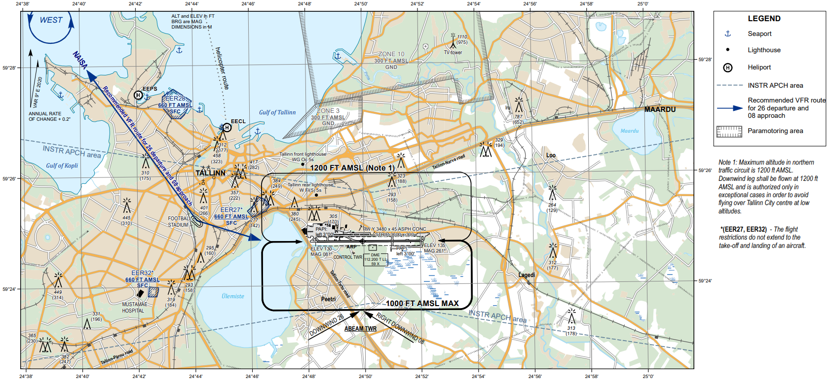
There is no preferential runway at Tallinn, an ILS procedure is available on both runway. Any special information can be marked in the "remarks" box. Traffic patterns are published for both runway, both hands at 1 000ft ASML.
| ATIS station | Frequency |
|---|---|
| Tallinn Information | 131.905 MHz |
¶ Traffic areas
The tower will assign a gate number to arriving aircraft. General aviation aircraft will be required to use their designated apron area.

¶ Aircraft gate management
Located in front of the terminal (Apron M), the commercial aviation parking has parking spaces for the different categories (see below).
TERM : Gates from M2 to M8 / M5 to M13 / M12 and M15
APN M : Gates M14 / M16 to 31
TERM is to be used mainly, if no more gate available, then assign a gates on the APM M to the aircraft.
| Stand | Airlines | Aircraft types |
|---|---|---|
| M2 - M8 / M5 - 15 / APN M | Air Baltic | BCS3 |
| M2 - M4 | Finnair | AT75 |
| M2 - M8 / M5 - M13 | LOT | E195 |
| TERM | SkyUp Airlines | B738 |
| M12 - M15 | Freebird Airlines | A320 |
| TERM | SunExpress | B38M |
| TERM | Corendon Airlines | B738 |
| M33 - M41 | DHL - ASL - Airest | B752 - B738 - SF34 |
| APN M | SprintAir | SF34 |
| APN M | Nyxair | AT45 |
| TERM | SAS | CRJ9 |
| TERM | Ryanair | B738 |
| TERM | Lufthansa | A320 |
| TERM | Turkish Airlines | B738 |
| TERM | Heston Airlines | A320 |
| TERM | Nordicair | A320 |
| APN Y3 | Border Guard | All |
| APN Y2 | Aerial Firefighter | All |
| APN Y5 to Y6 | General Aviation | All |
| K1 - K15 | Storage | All |
¶ Squawk code
For better traffic management in the Name airspace, here are the squawk codes to assign to traffic according to their destination.
| Flight | Code |
|---|---|
| IFR - Domestic | 0020 - 0037 / 4040 - 4077 |
| IFR - International | 5271 - 5277 |
| VFR - Domestic/International | 7030 - 7077 |
| IFR - Militaary | 7250 - 7257 |
¶ Characteristics of the taxiways
Please find bellow the different taxiway :
| Taxiways description | Traffic taxiways | ||
|---|---|---|---|
| Taxiway width (m) | Strength/PCN | ||
| A | 23 | 78/F/A/X/T | |
| B | 23 | 71/F/A/X/T | |
| C | 23 | 85/F/A/X/T | |
| D | 18 | 26/F/B/X/T | |
| E | 23 | 47/F/A/X/T | |
| F | 23 | 97/F/A/X/T | |
| G | 23 | 97/F/A/X/T | |
| H | 23 | 97/F/A/X/T | |
| S | 23 | 97/F/A/X/T | |
| T | 23 | 97/F/A/X/T | |
| Z | 23 | 97/F/A/X/T | |
¶ CTR description
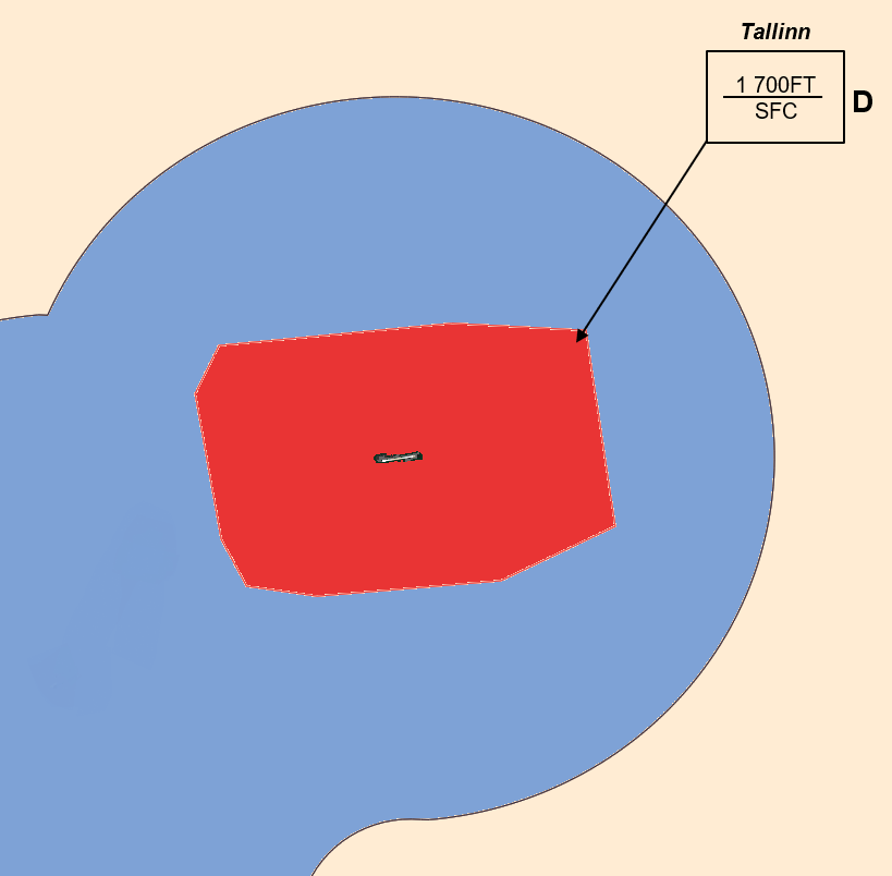
Tallinn airport has a class D CTR, starting from the surface, and going up to 1 700t AMSL.
¶ VFR entries, exits, transits in CTR
CTR entries, exits and transit are normally made after coordination with the approach controller. VFR transits will pass vertically from the airport at least 500ft above the higher aerodrome traffic patterns altitude (1 200ft AGL).
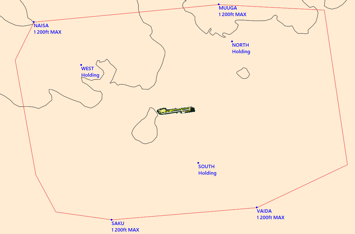
Traffic patterns are published both runways, both hands, however, south patterns are prefered to avoid the overflight of Tallinn city.
¶ TMA area description
The control sector of Tallinn represents three TMAs. The responsible ATC station is the Tallinn approach.

¶ Restricted areas (TMA area)
| Identification | Lower/Upper limits | Remarks | ||
|---|---|---|---|---|
| EE(R) - 04 MATSALU | Ground | 3 500ft AMSL | National Park. | |
| EE(R) - 15D | Ground | FL095 | Military air operations. | |
| EE(R) - 15F | Ground | FL095 | ||
| EE(R) - 16E | 5 000ft AMSL | FL095 | ||
| EE(R) - 16W | 5 000ft AMSL | FL095 | ||
| EE(R) - 18 | 5 000ft AMSL | FL095 | ||
| EE(R) - 21 | Ground | 2 200ft AMSL | An object of the Ministry of Defense's jurisdiction. | |
| EE(R) - 22 | Ground | 2 200ft AMSL | ||
| EE(R) - 23 | Ground | 2 200ft AMSL | ||
| EE(R) - 27 | Ground | 660ft AMSL | ||
| EE(R) - 28 | Ground | 660ft AMSL | ||
| EE(R) - 29 | Ground | 660ft AMSL | ||
¶ Danger areas (TMA area)
| Identification | Lower/Upper limits | Remarks | ||
|---|---|---|---|---|
| EE(D) - 05 KILTSI | Ground | 2 100ft AMSL | Gunfiring. | |
| EE(D) - 06 PAHKLA | Ground | 2 300ft AMSL | ||
| EE(D) - 07 PIIRSALU | Ground | 2 200ft AMSL | ||
| EE(D) - 13 TAPA 1 | Ground | 2 400ft AMSL | ||
| EE(D) - 14 TAPA 2 | Ground | 14 700ft AMSL | ||
| EE(D) - 16 KLOOGA 1 | Ground | 2 100ft AMSL | Gunfiring and military air operations. | |
| EE(D) - 20 MÄNNIKU | Ground | 1 700ft AMSL | Gunfiring. | |
| EE(D) - 23 NAISSAAR | Ground | 4 000ft AMSL | ||
| EE(D) - 35G | Ground | 2 200ft AMSL | Gliding activity. | |
¶ Specials areas (TMA area)
| Identification | Lower/Upper limits | Remarks | ||
|---|---|---|---|---|
| KUUSIKU | Ground | FL130 | Parachute Jumping Areas. | |
| Zone 3 - Lasnamägi | Ground | 300ft AMSL | Paramotoring Areas. | |
| Zone 5 - Jägala | Ground | 300ft AMSL | ||
| Zone 10 - Pirita - Viimsi | Ground | 300ft AMSL | ||
| Zone 1 | Ground | 300ft AMSL | Exercise and Training Zones. | |
| Zone 6 | Ground | 300ft AMSL | ||
¶ Standard instrument departure (SID)
| Runway | RNAV or Conventional SID | Altitude init or FLinit | ||
|---|---|---|---|---|
| RWY 08 |
BIRSI 1S | RNAV | 4 000ft AMSL | |
| GONOS 1S | 4 000ft AMSL | |||
| INTOR 1S | 4 000ft AMSL | |||
| LONSA 1S | 4 000ft AMSL | |||
| MOHNI 1S | 4 000ft AMSL | |||
| NITSO 1S | 4 000ft AMSL | |||
| ORTAX 1S | 4 000ft AMSL | |||
| OSMUR 1S | 4 000ft AMSL | |||
| PETOT 1S | 4 000ft AMSL | |||
| MUHMU 1S (COPTER) | By ATC | |||
| RWY 26 |
BIRSI 1T | RNAV | 4 000ft AMSL | |
| GONOS 1T | 4 000ft AMSL | |||
| INTOR 1T | 4 000ft AMSL | |||
| LONSA 1T | 4 000ft AMSL | |||
| MOHNI 1T | 4 000ft AMSL | |||
| NITSO 1T | 4 000ft AMSL | |||
| ORTAX 1T | 4 000ft AMSL | |||
| OSMUR 1T | 4 000ft AMSL | |||
| PETOT 1T | 4 000ft AMSL | |||
| IPOCA 1T (COPTER) | By ATC | |||
¶ Standard instrument terminal arrival (STAR)
| Runway | RNAV or Conventional STAR | Remarks | ||
|---|---|---|---|---|
| RWY 08 |
DOBAN 1K | RNAV | 230kt maximum on TN901/VEMOX (IAF) 2 200ft at VEMOX or above |
|
| DOPIK 1K | ||||
| GONOS 1K | ||||
| KEMET 1K | ||||
| OSMUR 1K | ||||
| RENKU 1K | ||||
| SULUN 1K | ||||
| RWY 26 |
DOBAN 1L | RNAV | 230kt maximum on TN551/MOKEX (IAF) 2 200ft at MOKEX or above |
|
| DOPIK 1L | ||||
| GONOS 1L | ||||
| KEMET 1L | ||||
| OSMUR 1L | ||||
| RENKU 1L | ||||
| SULUN 1L | ||||
¶ Final Approach (FNA)
| Runway | Approach | IAF | FNA | Beacon |
|---|---|---|---|---|
| RWY 08 |
ILS | TN901/VEMOX | DME 6.2 RAD 261° OUT IBB 2 200ft |
IBB 108.3 MHz |
| LOC | TN901/VEMOX | DME 6.4 RAD 261° OUT IBB 2 200ft |
IBB 108.3 MHz |
|
| RNP Z | VEMOX | TN978 2 200ft |
/ | |
| RNP H (COPTER) | LEFSE/WALHE | TN070 1 000ft |
/ | |
| RWY 26 |
ILS | TN551/MOKEX | DME 6.4 RAD 081° OUT ILK 2 200ft |
ILK 109.3 MHz |
| LOC | TN551/MOKEX | DME 6.5 RAD 081° OUT ILK 2 200ft |
ILK 109.3 MHz |
|
| RNP Z | MOKEX | TN627 2 200ft |
/ | |
| RNP H (COPTER) | MUHMU/FUCPO | TN064 1 000ft |
/ |