¶ Tokyo Terminal Area
In this article, you will information useful to connect as RJTT_APP (Roughly Tokyo TMA) as well as all positions for the airports below.
Tokyo Terminal Area is a class E volume of airspace responsible from GND to FL240. Tokyo TMA covers the busy Haneda and Narita as well as many other airbases and airfields. These airfields usually have Class D and C airspace around them.
Although the Tokyo ACA ceiling is FL240, initial altitudes from RJTT are set to FL200 west bound and FL190 or below set depending on the SID for north and east bound departures. FL240 handoffs are rarely made.
Airports with scheduled Air Transport Operations:
Narita RJAA, Chōfu Airport RJTF*, Oshima Airport RJTO, Haneda RJTT, Hyakuri / Ibaraki RJAH (Also Mil.), Niijima RJAN.
Airbases:
Kasumigaura RJAK, Atsugi RJTA, Tachikawa RJTC, Tateyama RJTE (Only Hel.), Kizarazu RJTK, Iruma RJTJ, Shimofusa RJTL, Yokota RJTY, Camp Zama RJTR (Only Hel.).
Other ADs:
Honda Airport RJT1 (small airstrip for G/A in Kawajima); Ryūgasaki RJA3 (Private G/A).
RED = Untowered AD. GREEN = Information service only.
* Chōfu sees mostly G/A ops. Scheduled operations to the islands (RJTO, RJAN, RJAZ and RJTQ) operated by NCA New Central Airservice on Dornier 228 aircraft.
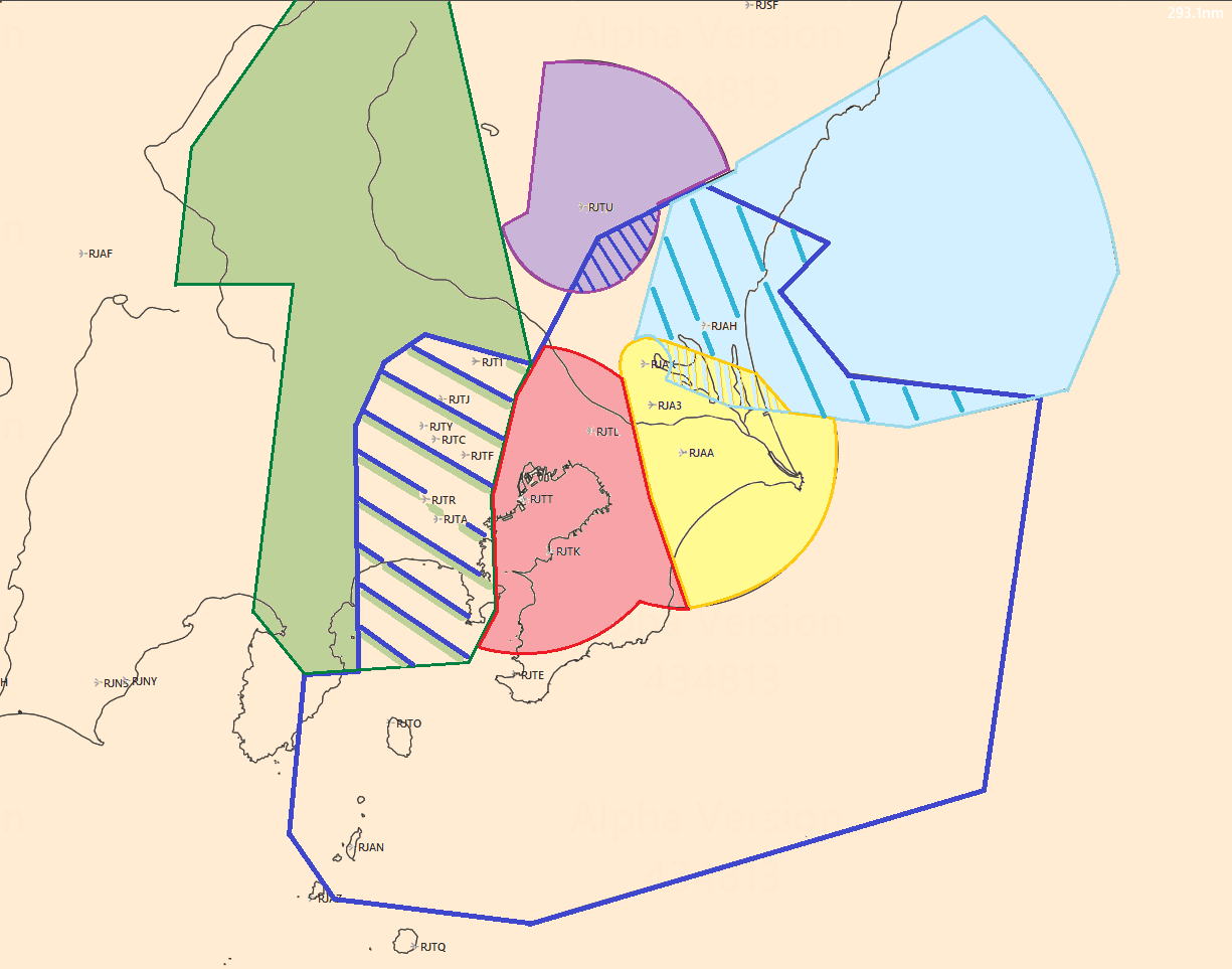
Let´s take a quick look at the differences airspace to be considered around Tokyo TMA:

The BLUE outline represents Tokyo TMA, avilable as RJTT_APP in Ivao, 119.1 MHz. Class E from GND to FL240.
RED area represents the western side of Tokyo TCA. It is available as RJTT_TT_APP on 124.750 MHz. Class E, from 1800ft to 10000ft.
YELLOW area represents the eastern side of Tokyo TCA. In Ivao this translates as RJTT_AA_APP on 119.450 MHz. Class E, from 2000ft to 10000ft.
The combined East and West sectors (red + yellow areas) are available as RJTT_ TCA_APP on 119.700 MHz
*TCA = Terminal Control Area
Military Green represents Yokota TMA (RJTY_APP). Class E GND to FL230. Yokota TMA.
Yokota TMA only responsible up to 8000ft in the area where it overlaps Tokyo TMA.
Light blue represents Hyakuri TMA (RJAH_APP). Class E GND to FL230.
Hyakuri TMA only goes up to altitudes between 1800ft and 10000ft where it overlaps Tokyo TMA.
Traditionally an airbase, Ibaraki airport ha recently begin serving low cost carriers as well.
Purple area represents Utsunomiya TMA (RJTU_APP). Class E GND to 7000ft.
Utsunomiya TMA only goes up to 4000ft where it overlaps Tokyo TMA.
Now looking at lower airspaces we find:
¶ Tokyo Haneda RJTT:

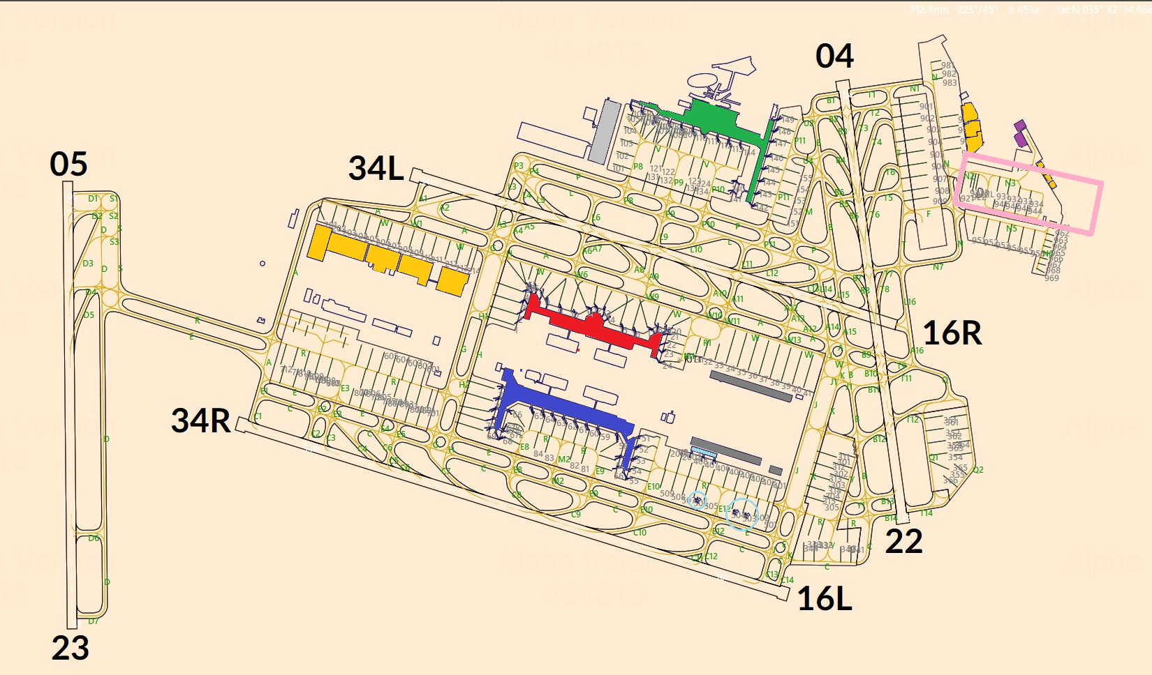
¶ Airport diagram:
Red: Terminal 1 (Domestic), Japan Airlines JAL
Blue: Terminal 2 (Domestic, some Intl´ Operations) All Nippon Airlines
Light Blue: Terminal 2 Satellite
Green: Terminal 3 (International)
Yellow: Maintenance Hangars
Light Grey: International Cargo
Grey: Cargo
Purple: Coast Guard
Pink Square: Private / General Aviation parking
RWY 05 Only usable for departures, RWY 23 only usable for arrivals.
RWY 04 Only usable for departures.
Taxi Routing:
Special routes with names:
| Name | Routing |
| Route 5 | A, R, S |
Flows:
Main runways are 34 L / R. Depending on wind and traffic load (Daily peaks), runway 05 and 34R will be used for departures while 34L handles arrivals.
When traffic and noise considerations allow, radar vectors to shortcut STARs are the norm.
¶ North Flow
Check out this real ATIS we have transcribed during the operation of the North flow:
"Tokyo Intl´. Airport Information Victor 13:00
ILS Z runway 34L approach and ILS Z runway 34R approach. Landing runway 34L and 34R. Departure runway 05 and 34R
Departure frequency 126.0
Simultaneous parallel ILS Approaches to runway 34L and R are in progress.
Runway 16R and 34L will be closed from 14:00.
Wind 080/11 Visibility 30Km BKN040ST 22/15 29.79 inches
Advise you have information Victor."
Runway 34L Arrivals
Runway 34R and 05 Departures
Changing to both 34L and 34R being used for arrivals furing the peak arrival rush.
| North flow arrivals (Good visibility) | ||||
|
Final Route Fix |
Primary |
Secondary |
||
|
IAP |
STAR |
IAP |
STAR |
|
|
XAC |
ILS X 34L |
OSHIMA 1K |
HIGHWAY VISUAL 34R |
OSHIMA 2H |
|
AKSEL |
AKSEL 1K |
AKSEL 2H |
||
|
AROSA |
AROSA 1K |
AROSA 2H |
||
|
GODIN |
HIGHWAY VISUAL 34R |
GODIN 1H |
ILS X 34L |
GODIN 2K |
|
POLIX |
POLIX 1H |
POLIX 2K |
||
| North flow arrivals (Poor visibility) | ||||
|
Final Route Fix |
Primary |
Secondary |
||
|
IAP |
STAR |
IAP |
STAR |
|
|
XAC |
ILS Z 34L |
OSHIMA 1A |
ILS Z 34R |
OSHIMA 2C |
|
AKSEL |
AKSEL 1A |
AKSEL 2C |
||
|
AROSA |
AROSA 1A |
AROSA 2C |
||
|
GODIN |
ILS Z 34R |
GODIN 1C |
ILS Z 34L |
GODIN 2A |
|
POLIX |
POLIX 1C |
POLIX 2A |
||
Taxi-in:
After landing 34L aircraft will turn and taxi south via A or L depending on their terminal. Aircraft taxiing to T2 will taxi east via H.
After landing 34R aircraft will taxi south via C. Or continue north until K. From join W southbound for the cargo apron
For both runways: East via K and B to enter apron P11 via U4.
E and P are used northbound in this configuration. G is used westbound.
Taxi out:
Exiting the aprons, aircraft will use L or A southbound, H eastbound and C southbound until R34R holding point.
Aircraft from T1 will cross runway 34L on L4 → A4 → H.
Or A and R southbound until S for HP runway 05. Aircraft from T1 will cross runway 34L using L3 → A3.
This flow becomes the night flow by using 34R for all arrivals and only 05 for departures as advised on the ATIS above.
What is the HIGHWAY VISUAL 34R ?:
HIGHWAY VISUAL 34R is an approach method that requires a visual on the highway for approach. Therefore, the controller will need to follow the following procedures to issue a clearance for this approach. (C: Controller, P: Pilot)
1. C: ANA102, Expect HIGHWAY VISUAL RWY34R approach.
P: Expect HIGHWAY VISUAL RWY34R approach, ANA102.
When the aircraft approaches CREAM, CLOAK or CAMEL and has the highway in sight.
2. C: ANA102, Report highway in sight.
P: Highway in-sight, ANA102.
3. C: ANA102, Roger. Cleared HIGHWAY VISUAL RWY 34R approach.
P: Cleared HIGHWAY VISUAL RWY 34R approach, ANA102.
When the aircraft approaches CAMEL and does not have the highway in sight.
2. C: ANA102, Report highway in sight.
P: Highway not in sight, ANA102
3. C: ANA102, Roger. Fly heading xxx re-vectors for approach.
P: Fly heading xxx, ANA102.
If multiple pilots cannot see the highway in sight, the controller responsible may change the approach operations to the “North Wind Approaches (unclear skies)” instead.
West Flow
Tokyo Intl´. Airport Information R 10:30
LDA W runway 22 approach and LDA W runway 23 approach. Landing runway 22 and 23.
Departure runway 16L and 16R. Departure frequency 126.0 from runway 16R 128.0 from runway 16L.
Simultaneous LDA approaches to runway 22 and runway 23 are in progress.
Wind 200/10 Visibility 30Km FEW030 Cumulus, BKN UNK, 23/16 29.90
Advise you have information R.
| South flow arrivals (Preferred configuration, Good visibility) | ||||
|
Final Route Fix |
Primary |
Secondary |
||
|
IAP |
STAR |
IAP |
STAR |
|
|
XAC |
LDA W 22 |
OSHIMA 1B |
LDA X 23 |
OSHIMA 2B |
|
AKSEL |
AKSEL 1B |
AKSEL 2B |
||
|
AROSA |
AROSA 1B |
AROSA 2B |
||
|
GODIN |
LDA W 23 |
GODIN 1D |
LDA X 22 |
GODIN 2D |
|
POLIX |
POLIX 1D |
POLIX 2D |
||
| South flow arrivals (Rarely used, bad visibility) | ||||
|
Final Route Fix |
Primary |
Secondary |
||
|
IAP |
STAR |
IAP |
STAR |
|
|
XAC |
ILS 22 |
OSHIMA 1N |
ILS Z 23 |
OSHIMA 2N |
|
AKSEL |
AKSEL 1N |
AKSEL 2N |
||
|
AROSA |
AROSA 1N |
AROSA 2N |
||
|
GODIN |
ILS Z 23 |
GODIN 1S |
ILS 22 |
GODIN 2S |
|
POLIX |
POLIX 1S |
POLIX 2S |
||
¶ South Flow
*This operation must only be used between 0600z to 1000z for a max of 3 hours.
|
Final Route Fix |
Primary |
Secondary |
||
|
IAP |
STAR |
IAP |
STAR |
|
|
XAC |
RNP 16L (ILS 16L) |
OSHIMA L |
RNP 16R (ILS 16R) |
OSHIMA R |
|
AKSEL |
AKSEL L |
AKSEL R |
||
|
AROSA |
AROSA L |
AROSA R |
||
|
GODIN |
RNP 16R (ILS 16R) |
GODIN R |
RNP 16L (ILS 16L) |
GODIN L |
|
POLIX |
POLIX R |
POLIX L |
||
¶ Night Flow
Tokyo Intl. Airport information F. 17:30
East flow (Used due to wind and in nighttime for reduced noise footprint):
Arrivals on and 23, departures 34R
Taxi Routings:
Taxi in for runway 23 arrivals:
S, R -→ A
Taxi out for runway 05 departures:
A, R -→ S
¶ Departure summary
|
Route/SID/Airway |
Departing Runway |
||
|
North Winds |
South Winds(Prim) |
South Winds(Sec) |
|
|
ROVER, SEKIYADO |
RWY 34R |
RWY 16L |
RWY16R |
|
TIARA |
RWY 34R |
RWY 16R |
RWY 22 |
|
NINOX, LAXAS, BEKLA, GUSRO, ISOGO, RUTAS, VADAR, VAMOS |
RWY 05 |
RWY 16R |
RWY 22 |
|
OPPAR |
RWY 05 |
X |
X |
Departure SIDs:
RJTT has many SIDs with A/B/C variations. These variations are decided by wind and time.
North Wind Departures:
A Departures: 2100z ~ 2200z, 0230z~C Departures(3hrs)~1400z
B Departures: 2200z~0230z
C Departures: 3 hrs only within 0600z~1000z
Midnight Ops: 1400z~2100z
South Wind Departures:
A Departures: 2100z ~ C Departures(3hrs)~1400z
B Departures: 2200z~0230z
C Departures: 3 hrs only within 0600z~1000z
Midnight Ops: 1400z~2100z
*C Departures are only used when South Wind Approaches (Secondary) are in use.