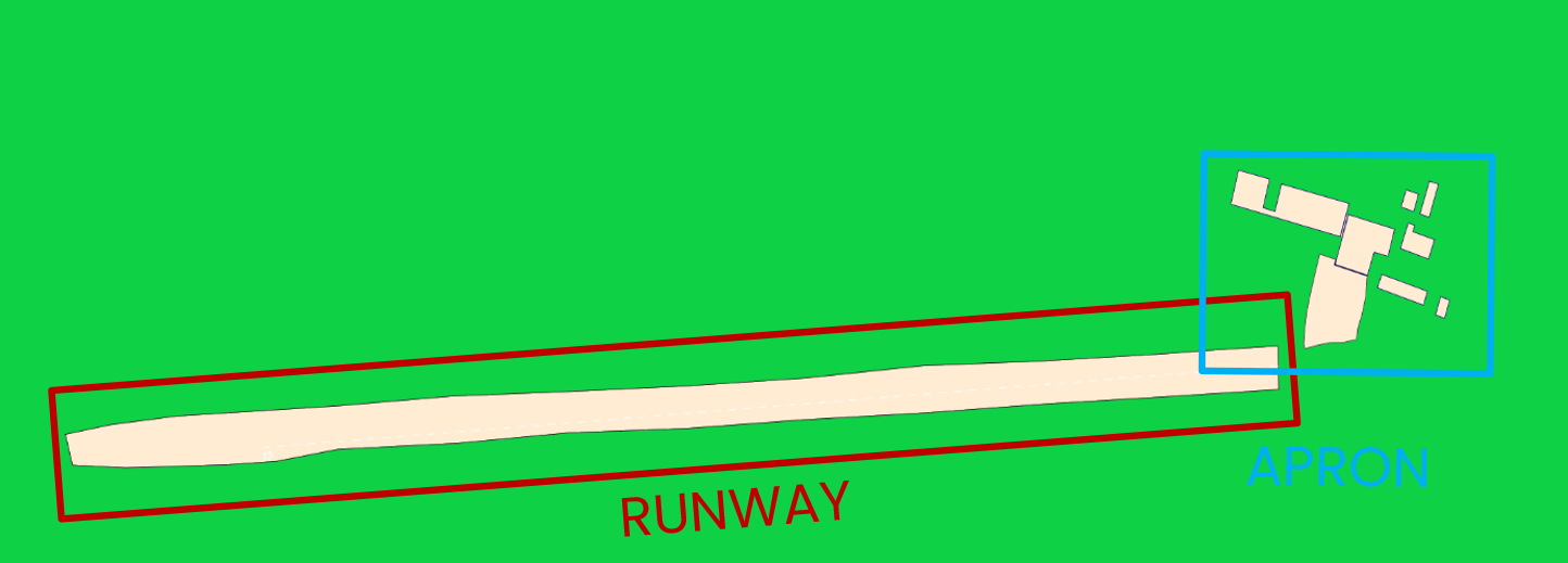
¶ Introduction
This OPMAN (OPeration MANual) presents all the air procedures and rules applicable in the airspace of Mauritius (FIMM FIR).
In addition, the airports of Sir Seewoosagur Ramgoolam International Airport (FIMP) and Plaine Corail Airport (FIMR) are detailed (IFR and VFR procedures). Some country airfields are also presented (not exhaustive).
This document is the responsibility of the HQ ATC department. For any questions/comments, you can contact them via the following e-mail address : a-srdep@ivao.aero
Link to the national eAIP : https://civil-aviation.govmu.org/Pages/AIPublication.aspx
¶ History of modifications
| Version | Modifications | VID | Validation month |
|---|---|---|---|
| FIMM_01 | Document creation | 610609 | 14/2022 |
| FIMM_02 | AIRAC 2203 : New SID/STAR/FNA, CTR and CTA, and VFR PROC | 610609 | 03/2023 |
| FIMM_03 | Update to new format | 610609 | 10/2023 |
¶ Documentary organization
The OPMAN is divided into 3 mains parts:
- General rules and procedures (GEN)
This section will address national regulations and requirements, applicable units of measure, and services.
- En-route (ENR)
This section will cover ATS airspace, ATS routes, navigation aids and systems, and navigation hazards (P, R, D zones, ...).
- Aerodromes (AD)
This section will discuss aerodromes and heliports.
And three annexes :
- ANNEX 1 : Quick Handle Memo of the FIR
This annex will summaries all important information needed while controlling.
- ANNEX 2 : FRA restrictions inside the FIR and laterals limits
This annex while present every different position in the FIR and the FRA associated, and the laterals limits of airspaces
- ANNEX 3 : List all the LoA concerning the FIR
This annex will list all the LoA – if existing – in the FIR.
¶ GENERAL RULES AND PROCEDURES (GEN)
¶ Visual flight rules
Except for special VFR, VFR flights must be operated in conditions of visibility and distance from cloud.
VFR flight shall not be flown :
- over cities at a height of less than 300m (1000ft),
- at a height of less than 150m (500ft) above ground or water.
VFR flights shall not take off, land, and cross any airspace if :
- the ceiling is less than 450 M (1500 ft),
- the visibility is less than 5KM.
VFR flights are not allowed :
- above FL200,
- at transonic and supersonic speeds,
- beyond 20 NM from shoreline.
Unless authorized by ATS, VFR flights will only be conducted below FL200.
Except for operational purposes (take-off, landing), no VFR flights will be conducted below 300m (1000ft) of height from heavily populated areas ; within a radius of 600m.
Except for these areas, the overflight height must be 150m (500ft) above the ground, or ocean.
Unless otherwise authorized, the sending of a flight plan is mandatory. All boxes (1 to 18) must be completed.
¶ Instrument flight rules
An aircraft in IFR flight in the cruise phase within controlled airspace will use a cruise level. See Appendix 3 of ICAO Annex 2.
Aircraft in IFR flight, entering a control area to land, will be cleared to the specified holding point. They will receive instructions from the approach controller (time, level, next position). These instructions must be respected. Otherwise, the waiting procedure will be executed.
IFR departures from an uncontrolled aerodrome must contact the Area Control Center.
The Transition Altitude of Mauritius FIR is 4 000 feet. The first usable flight level is FL060.
An IFR flight plan must be sent and completed.
Position report are mandatory within the Mauritius FIR, pilots shall report position as specified in 3.6.3 Of ICAO Annex 2 for controlled flight.
Find more about IFR separation without radar here : IFR_Separation_without_radar
¶ ATS airspace classification
ATS airspaces are classified and designated as detailed in ICAO Annex 11, Chapter 2.6. No specific rules are complementary.
IVAO Documentation about this : Airspace_classification
¶ Rules of the air
It is forbidden to fly over the cities of Port-Louis at less than 3500 ft, except for take-off and landing.
SSR equipment does not exist on the Mauritius facilities, only ADS (Automatic Dependent Surveillance). The special measures for this equipment are not taken into account.
Primary radars are unable to detect the altitude and speed of an aircraft.
The information given by the AURORA software is only a complementary tool to know the exact position of the aircraft. ATC manages the flow of traffic thanks to the pilots' position report (procedural control).
There is no published Minimum (Radar) Vectoring Altitude allowing air traffic management by "radar vectors". No heading can be provided to ensure safe obstacle clearance.
In the Terminal Control Area (TMA), in the Control Zone (CTR) position reports are mandatory for VFR flights.
Position report shall contain :
a) Aircraft identification
b) Position
c) Time
d) Flight level or altitude
e) Next position and time over
f) Ensuing significant point
¶ Units used inside the FIR
| For measurement of | Unit used |
|---|---|
| Distance used in navigation, position reporting, etc - generally in excess of 2 NM | Nautical miles and tenths |
| Relatively short distances such as those relating to aerodromes (e.g., runway lengths) | Meters |
| Altitudes, elevations and heights | Feet (meters) |
| Horizontal speed including wind speed | Knots |
| Vertical speed | Feet per minute (meters per second) |
| Wind direction for landing and taking off | Degrees Magnetic |
| Wind direction except for landing and taking off | Degrees True |
| Visibility, incl. runway visual range | Kilometers or meters |
| Altimeter setting | Hectopasca |
| Temperature | Degrees Celsius |
| Weight | Meter tones or Kilograms |
| Time | Hours and minutes, beginning at midnight UTC |
¶ EN-ROUTE (ENR)
¶ ATS airspaces
¶ Horizontal sectorizations, CTR, CTA and TMA
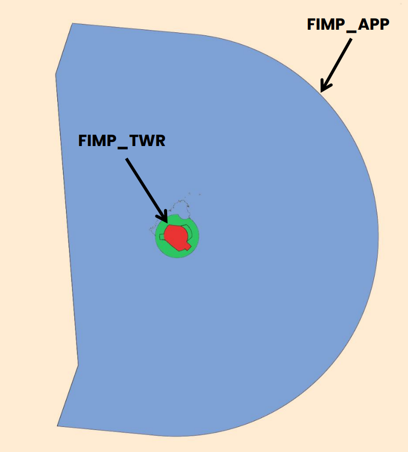
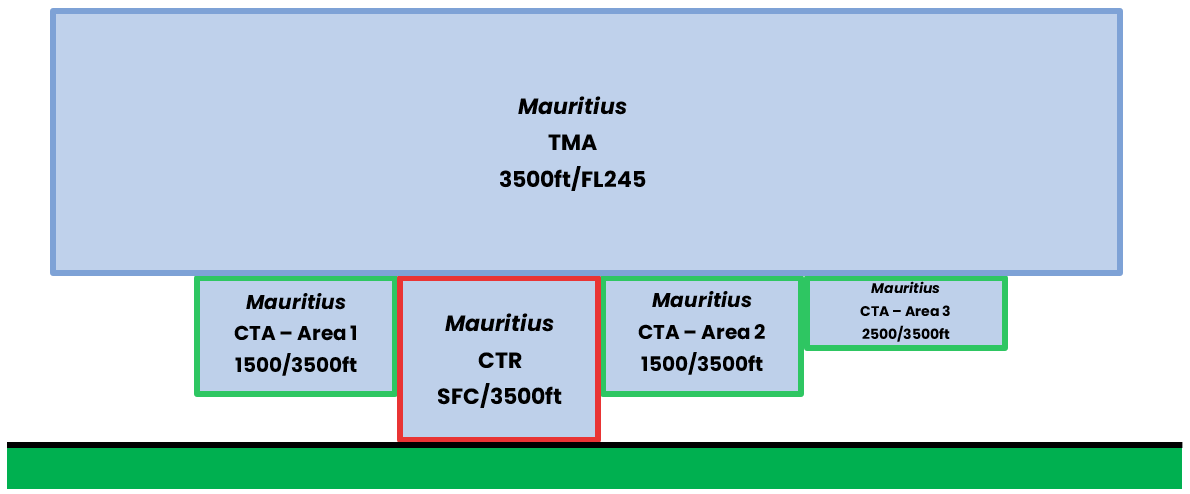
See below the ATC frequencies and the different airspace classes.
¶ Vertical sectorizations, CTR, CTA and TMA
| Name (Languages) |
Laterals limits | Verticals limits | Areas and conditions | Callsign and Frequencies |
|---|---|---|---|---|
| Mauritius TMA (English, French) |
See Annex 2 | 3 500ft / FL245 | TMA C Airspace |
Mauritius Approach FIMP_APP 119.100 MHz |
| Mauritius CTA - Area 1 (English, French) |
See Annex 2 | 1 500ft / 3500ft | CTA C Airspace |
Mauritius Approach FIMP_APP 119.100 MHz |
| Mauritius CTA - Area 2 (English, French) |
See Annex 2 | 1500ft / 3500ft | CTA C Airspace |
Mauritius Approach FIMP_APP 119.100 MHz |
| Mauritius CTA - Area 3 (English, French) |
See Annex 2 | 2500ft / 3500ft | CTA C Airspace |
Mauritius Approach FIMP_APP 119.100 MHz |
| Mauritius CTR (English, French) |
See Annex 2 | GND / 3500ft | CTR C Airspace |
Mauritius Tower FIMP_TWR 118.100 MHz |
¶ Horizontal sectorizations, FIR and UIR
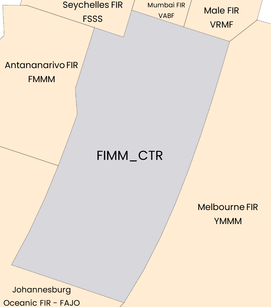
Below, the sectors adjacent to the FIR of Mauritius.
| Name (Languages) | Callsign | Frequencies |
|---|---|---|
| Mauritius FIR (English, French) |
FIMM_CTR (Mauritius Center) | 129.300 MHz |
| Antananarivo FIR (English, French) |
FMMM_CTR (Antananarivo Control) | 128.900 MHz |
| Seychelles FIR (English) |
FSSS_CTR (Seychelles Control) | 120.200 MHz |
| Mumbai FIR (English) |
VABF_OC_CTR (Mumbai Radio) | 132.600 MHz |
| Male FIR (English) |
VRMF_CTR (Male Control) | 123.900 MHz |
| Melbourne FIR (English) |
YMMO_CTR (Melbourne Oceanic) | 120.100 MHz |
| Johannesbourg Oceanic FIR (English) |
FAJO_CTR (Johannesburg Oceanic Center) | 133.060 MHz |
According to the previous table, here is the representation of the FIR airspace of Name.
¶ Vertical sectorizations, FIR and UIR
| Name (Languages) |
Laterals limits | Verticals limits | Areas and conditions | Callsign and Frequencies |
|---|---|---|---|---|
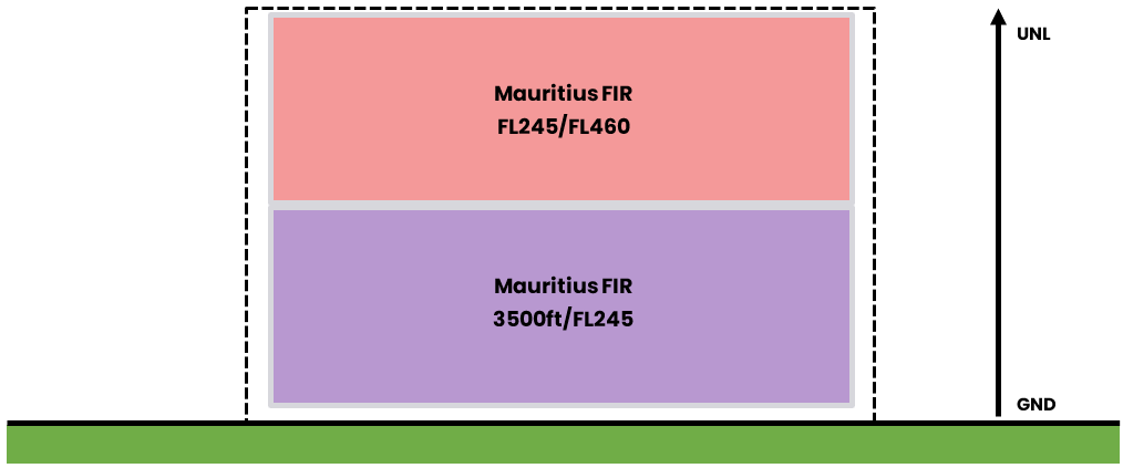
| Mauritius FIR (English, French) |
See Annex 2 | FL245/FL460 | FIR A airspace |
Mauritius Centre FIMM_CTR 129.300 MHz |
| 3 500ft/FL245 | FIR G airspace |
¶ ATS Route
¶ Upper/Lower ATS routes
This section details the routes in the upper and lower airspace.
| Designation of the route | Level | Route designation (FIX)* | Observation |
|---|---|---|---|
| L516 | Odd/Even | BUMMR ⇆ NKW | Class A above FL245 - - - Class C below FL245 |
| Q200 | Odd | OKMIN → PASAR | |
| Q201 | Even | EKBAL → MP204 | |
| Q202 | Odd | MP211 → SOBAT | |
| Q203 | Even | EKBAL → IMPAN | |
| Q204 | Odd | IMPAN → OKMIN | |
| Q205 | Even | PASAR → MP202 | |
| Q207 | Even | PASAR → EKBAL | |
| R329 | Odd/Even | MOMMA ⇆ NKW | |
| R348 | Odd/Even | RUPIG ⇆ LATEP | |
| T602 | Odd/Even | IMPAN ⇆ EPSIT | |
| UM314 | Odd/Even | AMBAN ⇆ NIBIS | |
| UR212 | Odd/Even | PERRY ⇆ GUDUG | |
| UT200 | Even | KADEM → UTROD | |
| UT201 | Odd | OKROS → KADEM | |
| UT330 | Even | NKW → UVARI | |
| UT331 | Odd | TEVOD → NKW | |
| UT400 | Even | ALRAN → DUNRI | |
| UT401 | Odd | DURDA → ALRAN | |
| UT451 | Odd/Even | RAXES ⇆ SUNKI | |
| UT454 | Even | BOBOD → OKBOG | |
| UT457 | Odd | TIKOL → BOBOD | |
| UT475 | Odd | TIDUM → MURUS | |
| UT594 | Even | SOLIT → IMRUL | |
| UT595 | Odd | ATLOP → SOLIT |
¶ Radio navigation aids/systems en-route
| Name of station | ID | Frequency | Coordinates | Remarks |
|---|---|---|---|---|
| Plaisance DVOR/DME - TACAN |
PLS | 113.700 MHz | 20°25’12”S 057°39’44”E |
/ |
| Grand Bay DVOR/DME - TACAN |
GBY | 114.800 MHz | 20°00’53”S 057°36’04”E |
/ |
| Plaisance NDB |
MS | 343 kHz | 20°26’25”S 057°41’26”E |
Coverage 300 NM |
| Flic-en-Flac NDB |
FF | 258 kHz | 20°16’53”S 057°22’18”E |
Coverage 100 NM |
| Rodrigues NDB |
RS | 302 kHz | 19°45’35”S 063°21’37”E |
Coverage 250 NM |
| Agalega NDB |
AGG | 429 kHz | 10°22’00”S 056°36’00”E |
/ |
¶ Navigation warnings
¶ Prohibited areas
| Identification | Lower/Upper limits | Remarks | |
|---|---|---|---|
| FI(P) - 06 (PROHIBITED) |
Ground | 3 500ft AMSL | MBC Transmitter site. |
| FI(P) - 07 (PROHIBITED) |
Ground | 3 500ft AMSL | St. Louis Power Station. |
| FI(P) - 08 (PROHIBITED) |
Ground | 3 500ft AMSL | Fort Victoria Power Station. |
| FI(P) - 09 (PROHIBITED) |
Ground | 3 500ft AMSL | Mauritius Radio Station. |
| FI(P) - 10 (PROHIBITED) |
Ground | 3 500ft AMSL | Shell Depot (Roche Bois). |
| FI(P) - 11 (PROHIBITED) |
Ground | 3 500ft AMSL | Hydroelectric project. |
| FI(P) - 19 (PROHIBITED) |
Ground | 3 500ft AMSL | Gov. House et Treasury. |
| FI(P) - 20 (PROHIBITED) |
Ground | 3 500ft AMSL | GRNW Remand Prison. |
| FI(P) - 21 (PROHIBITED) |
Ground | 3 500ft AMSL | Petit verger Prison. |
| FI(P) - 22 (PROHIBITED) |
Ground | 3 500ft AMSL | Richelieu Open Prison. |
| FI(P) - 23 (PROHIBITED) |
Ground | 3 500ft AMSL | Central Prison. |
| FI(P) - 24 (PROHIBITED) |
Ground | 3 500ft AMSL | Phoenix Prison. |
| FI(P) - 25 (PROHIBITED) |
Ground | 3 500ft AMSL | Phoenix Prison. |
| FI(P) - 26 (PROHIBITED) |
Ground | 3 500ft AMSL | Special Prison. |
| FI(P) - 27 (PROHIBITED) |
Ground | 3 500ft AMSL | Rodrigues Prison. |
¶ Restricted areas
| Identification | Lower/Upper limits | Remarks | |
|---|---|---|---|
| FI(R) – 02 (RESTRICTED) | Ground | 3500 AMSL | No flight within this area except with special permission from the Director of Civil Aviation. |
| FI(R) – 03 (RESTRICTED) |
Ground | 3 500ft AMSL | |
| FI(R) – 04 (RESTRICTED) |
Ground | 3 500ft AMSL | |
| FI(R) – 05 (RESTRICTED) |
Ground | 3 500ft AMSL | |
| FI(R) – 17 (RESTRICTED) |
Ground | 3 500ft AMSL | |
¶ Danger areas
| Identification | Lower/Upper limits | Remarks | |
|---|---|---|---|
| FI(D) - 02 (DANGER) |
Ground | 3 500ft AMSL | Firing. |
| FI(D) - 03 (DANGER) |
Sea | 10 500ft AMSL | |
| FI(D) - 04 (DANGER) |
Ground | 6 000ft AMSL | |
| FI(D) - 05 (DANGER) |
Sea | 40 000ft AMSL | |
| FI(D) - 17 (DANGER) |
Sea | 40 000ft AMSL | |
| FI(D) - 18 (DANGER) |
Sea | 40 000ft AMSL | |
| FI(D) - 28 (DANGER) |
Ground | 3 000ft AMSL | |
¶ Specials areas
| Identification | Lower/Upper limits | Remarks | |
|---|---|---|---|
| Mon Loisir (TSA) | Ground | FL150 | From sunrise to sunset. Skydiving activities. |
¶ AERODROMES (AD)
¶ Sir Seewoosagur Ramgoolam International Airport – FIMP
¶ Airport Information
| Informations | |
|---|---|
| ICAO Code | FIMP |
| IATA Code | MRU |
| Airport name | Sir Seewoosagur Ramgoolam Intl. Airport (Mauritius) |
| Time zone conversion | UTC + 4 |
| Coordinates of the reference point and location of the airfield | 20° 25’ 48"S 057° 40’ 50"E |
| Direction and distance from (city) | 328° / 48km of Port Louis |
| Altitude / temperature reference | 56m (183 feet) / 29.7°C |
| Magnetic declination | 19° W |
| Permitted traffic types | IFR / VFR |
| Runway | 14 / 32 |
¶ Characteristic of the runway
The runway 14 - 32 has the following features :
| Description of the runway | Runway 14 | Runway 32 |
|---|---|---|
| Dimensions of runway (m) | 3 370 x 45 | 3 370 x 45 |
| True and Mag Brg | 117° True / 136° Mag | 297° True / 316° Mag |
| Strength (PCN) and surface of runway | 98/F/B/W/T - asphalt | 98/F/B/W/T - asphalt |
| Threshold coordinates | 20°25’28"S 057°40’19"E |
20°26’13"S 057°41’52"E |
| Threshold elevation | Threshold 56m (183ft) | Threshold 0m (98ft) |
| TORA (m) | 3 370 | 3 040 |
| TODA (m) | 3 670 | 3 190 |
| ASDA (m) | 3 370 | 3 040 |
| LDA (m) | 3 040 | 3 040 |
¶ ATS Communication facilities
| Designation service | Callsign | Frequency |
|---|---|---|
| Center | Mauritius Centre (FIMM_CTR) |
129.300 MHz |
| Approach | Mauritius Approach (FIMP_APP) |
119.100 MHz |
| Tower | Mauritius Tower (FIMP_TWR) |
118.100 MHz |
¶ Radio navigation and landing aids
| Type of aid | ID | Frequency | Informations |
|---|---|---|---|
| Plaisance DVOR/DME |
PLS | 113.700 MHz | 20°25’12"S 057°39’44"E |
| Grand Bay DVOR/DME |
GBY | 114.800 MHz | 20°00’53”S 057°36’04”E |
| Plaisance NDB |
MS | 343 kHz | 20°26’25”S 057°41’26”E |
| Flic-En-Flac NDB |
FF | 258 kHz | 20°16’53”S 057°22’18”E |
| Sir Seewoosagur Ramgoolam intl. ILS/DME |
IPL | 109.900 MHz | 20°25’29"S 057°40’30"E |
¶ Local airport regulation
¶ Automatic Terminal Information Service
The ATIS must be completed in English.
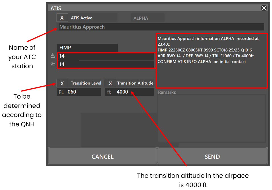
At the beginning of the session, please fill out the ATIS correctly. The transition altitude (TA) is 4 000ft. The transition level (TL) is to be determined according to the QNH. The first usable level is FL060.
There is no preferential runway, however an ILS procedure is available on runway 14. Any special information can be marked in the "remarks" box.
| ATIS station | Frequency |
|---|---|
| Sir Seewoosagur Ramgoolam Intl. Airport | 126.200 MHz |
¶ Traffic areas
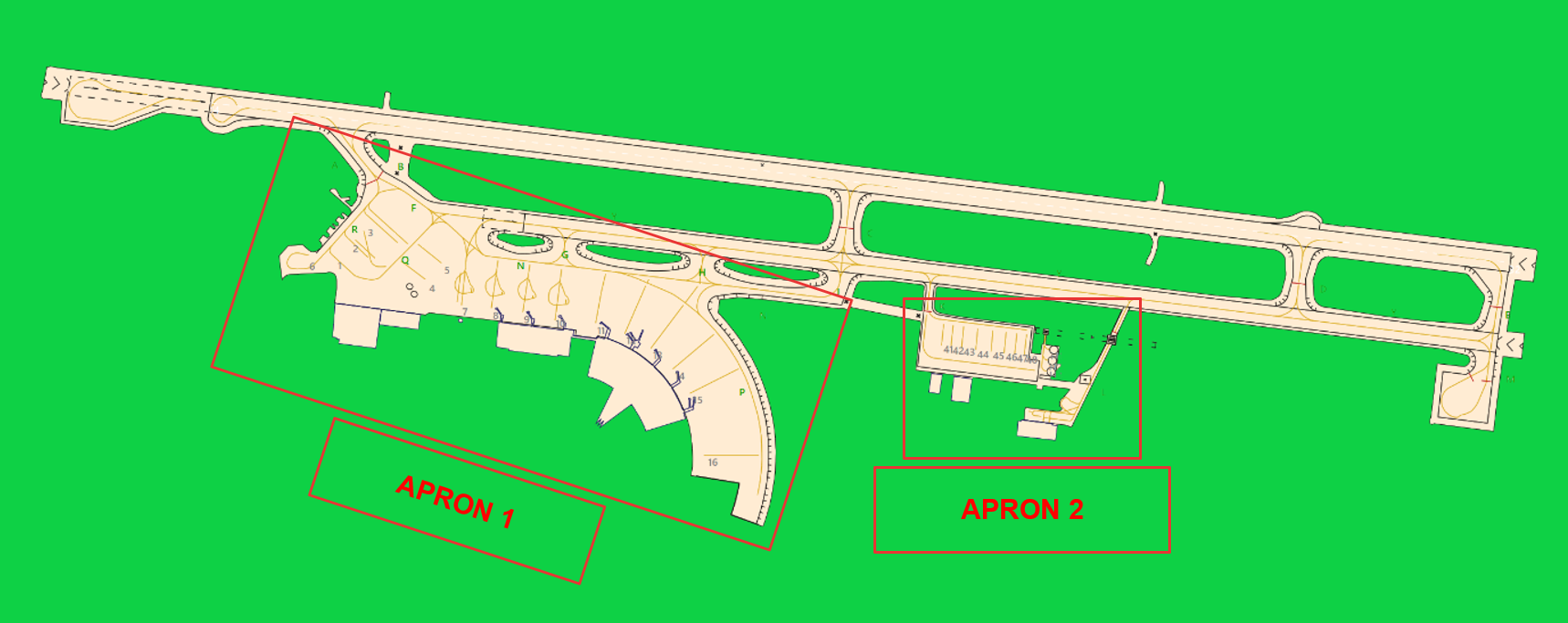
The Tower will assign a bay number to arriving aircraft. General aviation aircraft will be required to use their designated apron area.
¶ Aircraft gate management
Located in front of the terminal (Apron 1), the commercial aviation parking lot has 16 bay spaces for the different categories (see below).
| Stand | Airlines | Aircraft types |
|---|---|---|
| 1 - 5 and 7 | Air Mauritius | AT75 |
| 8 - 11 | All | BCS3 – A359 - B77W |
| 12 | All - Emirates | BCS3 – B77W – A388 |
| 13 - 16 | All | BCS3 – A359 - B77W |
| 41 - 48 | GA - Private | C680 |
| H1 - H3 | Air Mauritius – Corail hélicoptère | B06 - EC30 |
| APN L | National Coast Guard | D228 – AS50 |
¶ Squawk code
For better traffic management in the Mauritius airspace, here are the squawk codes to assign to traffic according to their destination.
There is no radar installation inside the Mauritius FIR, all ATCs services are done procedurally, and squawk can stay on 2000 during the flight.
Position report are mandatory for IFR and VFR within the Mauritius FIR, pilots shall report their position as specified in 3.6.3 of ICAO Annex 2 for controlled flight.
| Flight | Code |
|---|---|
| Domestic IFR | 0500 - 0577 and 0600 - 0677 and 0700 - 0777 |
| Transit | 4400 - 4477 |
| VFR | 1200 |
¶ Characteristics of the taxiways
Please find bellow the different taxiway :
| Taxiways description | Traffic taxiways | ||
|---|---|---|---|
| Taxiway width (m) | Geographical coordinates of the appropriate axial points of the taxiways | ||
| A | 31 | 20°25’38"S 057°40’29"E |
|
| B | CLOSED | CLOSED | |
| R | 29 | 20°25’39"S - 057°40’29"E | |
| Q | 30 | 20°25’43"S - 057°40’32"E | |
| F | 23 | 20°25’39"S - 057°40’31"E | |
| G | 57 | 20°25’48"S - 057°40’51"E | |
| N | 23 | 20°25’46"S - 057°40’35"E | |
| Y | 45 | 20°25’44"S - 057°40’37"E | |
| P | 30 | 20°25’56"S - 057°40’50"E | |
| H | 57 | 20°25’53"S - 057°40’51"E | |
| J | 51 | 20°25’57"S - 057°41’01"E | |
| C | 23 | 20°25’54"S - 057°41’03"E | |
| K | 18.7 | 20°26’00"S - 057°41’08"E | |
| D | 30 | 20°26’09"S - 057°41’36"E | |
| E | 27 | 20°26’16"S - 057°41’50"E | |
| M | None (storage) | 20°26’20"S - 057°41’48 E | |
| L | 15 | 20°26’06"S - 057°41’22"E | |
¶ CTR description
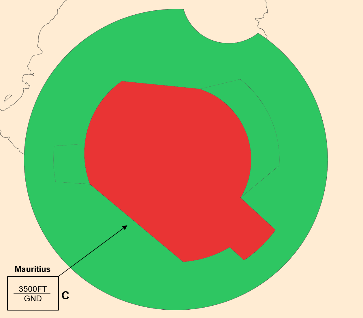
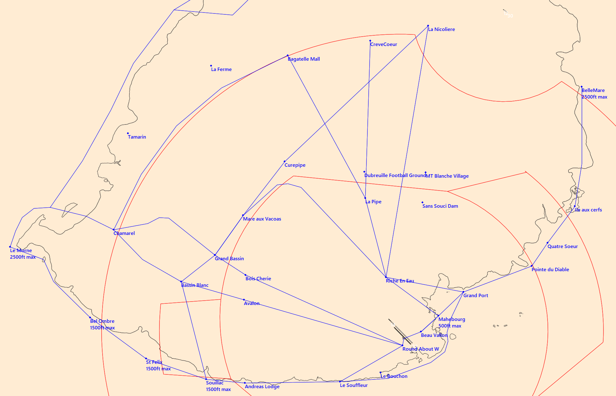
Sir Seewoosagur Ramgoolam airport has a class C CTR, starting from the surface, and going up to 3 500ft AMSL. One P area is located inside the CTR, and the aerodrome traffic circuit is not published.
¶ VFR entries, exits, transits in CTR
CTR entries and exits are normally made from the North and from the East after coordination with the approach controller. VFR transits will pass vertically from the airport at least 500ft above the presume aerodrome traffic patterns altitude (1 000ft AGL).
¶ TMA area description
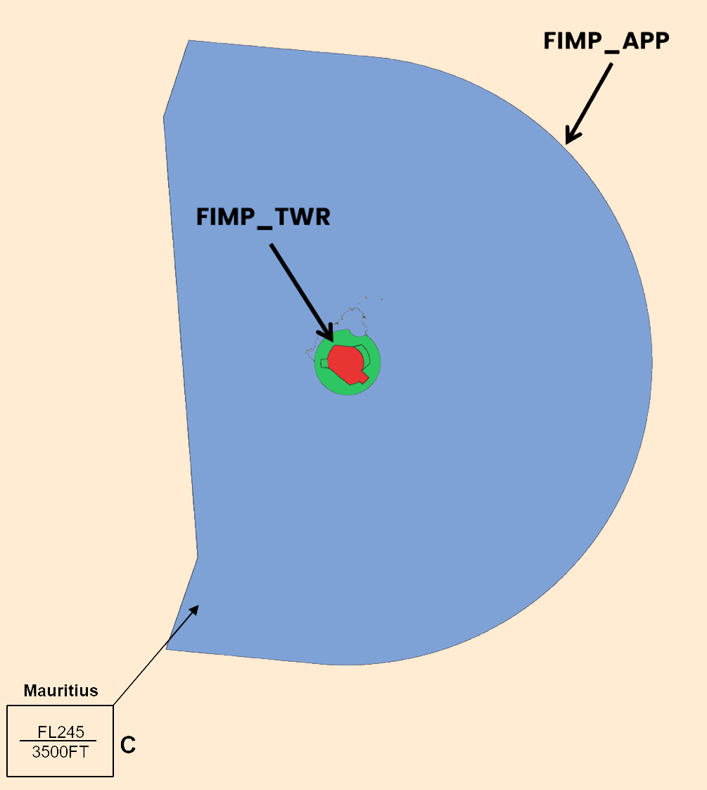
The control sector of Mauritius represents one TMA. The responsible ATC station is the Mauritius approach.
¶ Prohibited areas
| Identification | Lower/Upper limits | Remarks | |
|---|---|---|---|
| FI(P) - 06 (PROHIBITED) |
Ground | 3 500ft AMSL | MBC Transmitter site. |
| FI(P) - 07 (PROHIBITED) |
Ground | 3 500ft AMSL | St. Louis Power Station. |
| FI(P) - 08 (PROHIBITED) |
Ground | 3 500ft AMSL | Fort Victoria Power Station. |
| FI(P) - 09 (PROHIBITED) |
Ground | 3 500ft AMSL | Mauritius Radio Station. |
| FI(P) - 10 (PROHIBITED) |
Ground | 3 500ft AMSL | Shell Depot (Roche Bois). |
| FI(P) - 11 (PROHIBITED) |
Ground | 3 500ft AMSL | Hydroelectric project. |
| FI(P) - 19 (PROHIBITED) |
Ground | 3 500ft AMSL | Gov. House et Treasury. |
| FI(P) - 20 (PROHIBITED) |
Ground | 3 500ft AMSL | GRNW Remand Prison. |
| FI(P) - 21 (PROHIBITED) |
Ground | 3 500ft AMSL | Petit verger Prison. |
| FI(P) - 22 (PROHIBITED) |
Ground | 3 500ft AMSL | Richelieu Open Prison. |
| FI(P) - 23 (PROHIBITED) |
Ground | 3 500ft AMSL | Central Prison. |
| FI(P) - 24 (PROHIBITED) |
Ground | 3 500ft AMSL | Phoenix Prison. |
| FI(P) - 25 (PROHIBITED) |
Ground | 3 500ft AMSL | Phoenix Prison. |
| FI(P) - 26 (PROHIBITED) |
Ground | 3 500ft AMSL | Special Prison. |
¶ Restricted areas
| Identification | Lower/Upper limits | Remarks | |
|---|---|---|---|
| FI(R) – 02 (RESTRICTED) | Ground | 3500 AMSL | No flight within this area except with special permission from the Director of Civil Aviation. |
| FI(R) – 03 (RESTRICTED) |
Ground | 3 500ft AMSL | |
| FI(R) – 04 (RESTRICTED) |
Ground | 3 500ft AMSL | |
| FI(R) – 05 (RESTRICTED) |
Ground | 3 500ft AMSL | |
| FI(R) – 17 (RESTRICTED) |
Ground | 3 500ft AMSL | |
¶ Danger areas
| Identification | Lower/Upper limits | Remarks | |
|---|---|---|---|
| FI(D) - 02 (DANGER) |
Ground | 3 500ft AMSL | Firing. |
| FI(D) - 03 (DANGER) |
Sea | 10 500ft AMSL | |
| FI(D) - 04 (DANGER) |
Ground | 6 000ft AMSL | |
| FI(D) - 05 (DANGER) |
Sea | 40 000ft AMSL | |
| FI(D) - 17 (DANGER) |
Sea | 40 000ft AMSL | |
| FI(D) - 18 (DANGER) |
Sea | 40 000ft AMSL | |
| FI(D) - 28 (DANGER) |
Ground | 3 000ft AMSL | |
¶ Specials areas
| Identification | Lower/Upper limits | Remarks | |
|---|---|---|---|
| Mon Loisir (TSA) | Ground | FL150 | From sunrise to sunset. Skydiving activities. |
¶ Standard instrument departure (SID)
| Runway | Departure ID | Transition | Altitude or FL |
|---|---|---|---|
| RWY 14 (RNAV) |
EVANA 1 | / | To be determinated by ATC. |
| ETGOR 1 | |||
| IBSIS 1 | |||
| SOBAT 1 | |||
| OSKAR 1 | |||
| UDMED 1 | |||
| GABKI 1 | |||
| UTIVA 1 | |||
| OKMAR 1 | |||
| TIBAG 1 | |||
| NIBIS 1 | |||
| RASMA 1 | |||
| RWY 14 (RNP 1)* |
ATLOP 2A | / | To be determinated by ATC. |
| DUPNA 1A | TIDUM 1A DURDA 1A OKMAR 2A |
||
| ETGOR 1A | / | ||
| IMPAN 1A | |||
| NIBIS 2A | |||
| OKROS 1A | |||
| PASAR 2A | |||
| RASMA 2A | |||
| SOBAT 2A | |||
| URTUP 1A | EXIPU 1A TEVOD 1A TIKOL 1A TIDUM 1C DURDA 1C OKMAR 2C |
||
| RWY 32 (RNAV) |
SOBAT 1B | / | To be determinated by ATC |
| IBSIS 1B | |||
| ETGOR 1B | |||
| ESROL 1B | |||
| KINIX 1B | |||
| ATLOP 1B | |||
| GERUS 1B | |||
| UTIVA 1B | |||
| UDMED 1B | |||
| TAPER 1B | |||
| DUDIP 1B | |||
| GUTKO 1B | |||
| ARIGO 1B | |||
| OVTIS 1B | |||
| IXABI 1B | |||
| OKMAR 1B | |||
| RASMA 1B | |||
| NIBIS 1B | |||
| TIBAG 1B | |||
| RWY 32 (RNP 1)* |
ATLOP 2B | / | To be determinated by ATC. |
| IKMOV 1B | OKMAR 1B DURDA 1B |
||
| IMPAN 1B | / | ||
| IMPAN 1D | |||
| OKROS 1B | |||
| OKROS 1D | |||
| PASAR 2B | |||
| RASMA 2B | |||
| SOBAT 2B | |||
| TEVOD 1B | |||
| TIDUM 1B | |||
| UVDAG 1B | TIKOL 1B TEVOD 1B EXIPU 1B |
||
| UVDAG 1D | TIKOL 1D TEVOD 1D EXIPU 1D |
¶ Standard instrument terminal arrival (STAR)
| Runway/STAR | Transition | Remarks |
|---|---|---|
| RWY 14 FFLAC 1 (RNAV) |
ETKIS TRANS IBSIS TRANS ETGOR TRANS |
250kt maximum on FF (IAF) 4 000ft at FF or above |
| RWY 14 GABKI 1 (RNAV) |
GERIS TRANS ETSOL TRANS OKMAR TRANS UTIVA TRANS UDMED TRANS TAPER TRANS DUDIP TRANS GUTKO TRANS ARIGO TRANS OVTIS TRANS ARIGO TRANS OVTIS TRANS IXABI TRANS KINIX TRANS ATLOP TRANS |
250kt maximum on GABKI (IAF) 4 000ft at FF or above |
| RWY 32 GEVEV 1 (RNAV) |
ATLOP TRANS KINIX TRANS |
250kt maximum on GEVEV (IAF) 4 000ft at GEVEV or above |
| RWY 32 EPREX 1 (RNAV) |
UTIVA TRANS UDMED TRANS TAPER TRANS DUDIP TRANS GUTKO TRANS ARIGO TRANS OVTIS TRANS IXABI TRANS |
250kt maximum on EPREX (IAF) 4 000ft at EPREX or above |
| RWY 32 EVOTU 1 (RNAV) |
OKMAR TRANS UDMED TRANS TAPER TRANS DUDIP TRANS GUTKO TRANS ARIGO TRANS OVTIS TRANS IXABI TRANS |
250kt maximum on EVOTU (IAF) 4 000ft at EVOTU or above |
| RWY 14 (RNP 1)* |
DUNRI 1E RASMA 2E TIBAG 2E UNPUG 1E |
250kt maximum on IMKOV (IAF) FL060 at IMKOV or above |
| EPTEK 2E IMRUL 1E PASAR 2E |
250kt maximum on EKBAL (IAF) FL060 at EKBAL or above |
|
| IMPAN 1E OKBOG 1E UTROD 1E UVARI 1E |
210kt maximum on MP143 (IAF) FL060 at MP143 or above |
|
| RWY 32 (RNP 1)* |
IMPAN 1F IMRUL 1F OKBOG 1F UNPUG 1F UTROD 1F UVARI 1F |
250kt maximum on ESTEK (IAF) 3 600ft at ESTEK or above |
| DUNRI 1F EPTEK 2F PASAR 2F RASMA 2F TIBAG 2F |
250kt maximum on ESTEK (IAF) 3 600ft at ESTEK or above |
¶ Final Approach (FNA)
| Runway | Approach | IAF | FAF | Beacon |
|---|---|---|---|---|
| RWY 14 |
ILS DME Y | FFLAC / PLS | CPEPT 3200ft |
IPL 109.9 MHz |
| ILS Z* | EKBAL / IMKOV / MP143 | CPEPT 3 200ft |
IPL 109.9 MHz |
|
| LLZ DME Y | FFLAC / PLS | CPEPT 3 200ft |
IPL 109.9 MHz |
|
| LLZ DME IPL Z* | EKBAL / IMKOV / MP143 | CPEPT 3 200ft |
IPL 109.9 MHz |
|
| VOR PLS DME IPL Y | FFLAC / PLS | CPEPT 3 400ft |
PLS 113.7 MHz |
|
| VOR PLS DME IPL Z* | EKBAL / IMKOV / MP143 | CPEPT 3 200ft |
PLS 113.7 MHz |
|
| RNP Z | EKBAL / IMKOV / MP143 | CPEPT 3 200ft |
/ | |
| RWY 32 |
VORDME PLS Z* | MP500 / GEVEV / EVOTU / PLS) | DME 6.8 RAD 136° OUT PLS 1 740ft |
PLS 113.7 MHz |
| RNP Z* | ESTEK | EPNUK 740ft |
/ |
¶ Plaine Corail Airport – FIMR
¶ Airport Information
| Informations | |
|---|---|
| ICAO Code | FIMR |
| IATA Code | RRG |
| Airport name | Plaine Corail National Airport (Mauritius) |
| Time zone conversion | UTC + 4 |
| Coordinates of the reference point and location of the airfield | 19° 45’ 28"S 063° 21’ 41"E |
| Direction and distance from (city) | 039° / 20km of Port Mathurin |
| Altitude / temperature reference | 28m (93 feet) / 29.9°C |
| Magnetic declination | 18° W |
| Permitted traffic types | IFR / VFR |
| Runway | 12 / 30 |
¶ Characteristic of the runway
The runway 12 - 30 has the following features :
| Description of the runway | Runway 12 | Runway 30 |
|---|---|---|
| Dimensions of runway (m) | 1287 x 30 | 1287 x 30 |
| True and Mag Brg | 117° True / 136° Mag | 297° True / 316° Mag |
| Strength (PCN) and surface of runway | 15/F/A/X/T - asphalt | 15/F/A/X/T - asphalt |
| Threshold coordinates | 19°45’23"S 063°21’22"E |
19°45’32"S 063°21’58"E |
| Threshold elevation | Threshold 21m (69ft) | Threshold 25m (82ft) |
| TORA (m) | 1 217 | 1 197 |
| TODA (m) | 1 517 | 1 497 |
| ASDA (m) | 1 217 | 1 197 |
| LDA (m) | 1 087 | 1 127 |
¶ ATS Communication facilities
| Designation service | Callsign | Frequency |
|---|---|---|
| Center | Mauritius Center (FIMM_CTR) |
129.300 MHz |
| Tower (Information) | Corail Information (FIMR_I_TWR) |
122.100 MHz |
¶ Radio navigation and landing aids
| Type of aid | ID | Frequency | Informations |
|---|---|---|---|
| Rodrigues NDB |
RS | 302 kHz | 19°45’35"S 063°21’37"E |
¶ Local airport regulation
¶ Automatic Terminal Information Service
The ATIS must be completed in English.
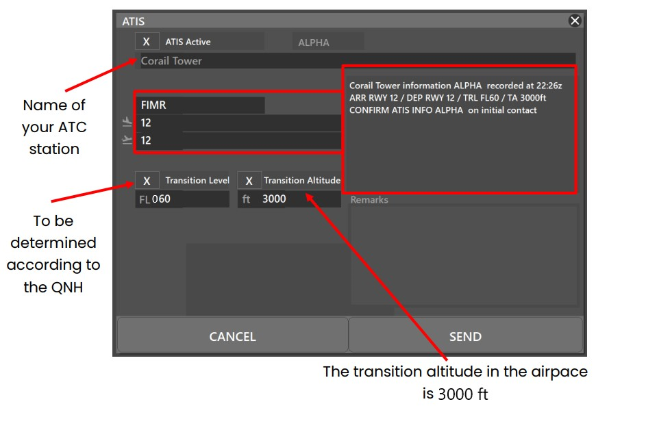
At the beginning of the session, please fill out the ATIS correctly. The transition altitude (TA) is 3 000ft. The transition level (TL) is to be determined according to the QNH. The first usable level is FL060.
There is no preferential runway, and both runways have the same type of approaches.
¶ Traffic areas
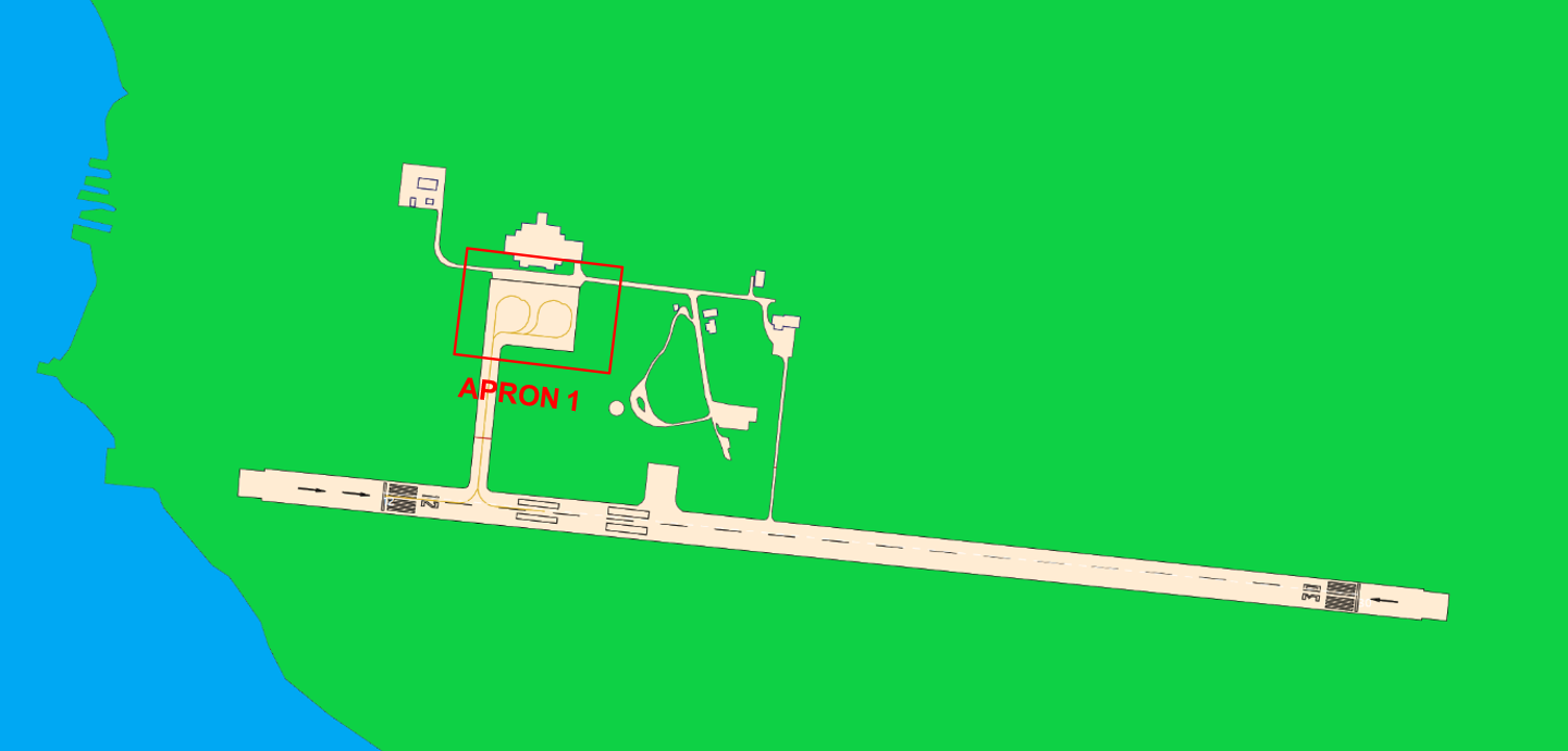
The Tower will assign a gate number to arriving aircraft.
¶ Aircraft gate management
Located in front of the terminal the commercial aviation parking lot has 2 parking spaces for the different categories (see below).
| Stand | Airlines | Aircraft types |
|---|---|---|
| 1 - 2 | Air Mauritius - Ewa Air | AT75 - AT76 |
¶ Squawk code
For better traffic management in the Mauritius airspace, here are the squawk codes to assign to traffic according to their destination.
There is no radar installation inside the Mauritius FIR, all ATCs services are done procedurally, and squawk can stay on 2000 during the flight.
Position report are mandatory for IFR and VFR within the Mauritius FIR, pilots shall report their position as specified in 3.6.3 of ICAO Annex 2 for controlled flight.
| Flight | Code |
|---|---|
| Domestic IFR | 0500 - 0577 and 0600 - 0677 and 0700 - 0777 |
| Transit | 4400 - 4477 |
| VFR | 1200 |
¶ Characteristics of the taxiways
Please find bellow the different taxiway :
| Taxiways description | Traffic taxiways | ||
|---|---|---|---|
| Taxiway width (m) | Geographical coordinates of the appropriate axial points of the taxiways | ||
| Main taxiway | 15 | 19°45’18"S 063°21’27"E |
|
¶ CTR description
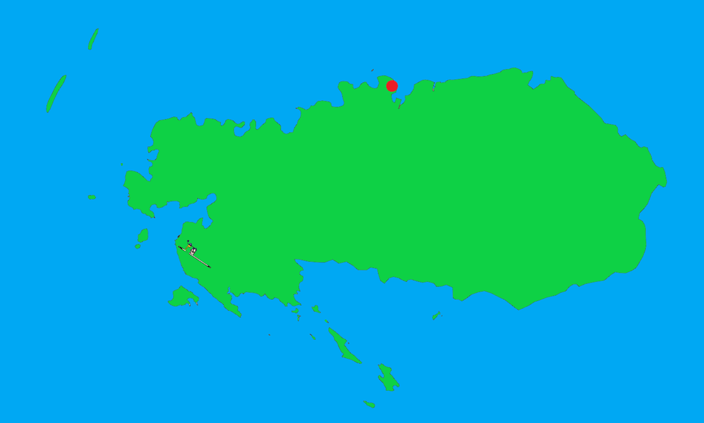
Plaine Corail airport has no CTR, with only one P area, and the aerodrome traffic circuit is not published.
¶ Prohibited areas (TMA area)
| Identification | Lower/Upper limits | Remarks | |
|---|---|---|---|
| FI(P) - 27 (PROHIBITED) |
Ground | 3 500ft AMSL | Rodrigues Prison. |
¶ Final Approach (FNA)
| Runway | Approach | IAF | FNA | Beacon |
|---|---|---|---|---|
| RWY 12 |
RNAV (GNSS) | EPSIT / IMR01 / IMR02 | IMR04 1 711ft |
/ |
| NDB | RS | DME 4.5 BRG 306° OUT RS 1 500ft |
RS 302 kHz |
|
| RWY 30 |
RNAV (GNSS) | IMR06 / IMR07 / IMR08 | IMR10 1 723ft |
/ |
| NDB | RS | DME 5.6 BRG 122° OUT RS 1 900ft |
RS 302 kHz |
¶ Mon Loisir Airstrip (Private) – FIML
¶ Airport Information
| Informations | |
|---|---|
| ICAO Code | FIML |
| IATA Code | / |
| Airport name | Mon Loisir Airstrip (Mauritius) |
| Time zone conversion | UTC + 4 |
| Coordinates of the reference point and location of the airfield | 20° 07’ 26"S 057° 40’ 54"E |
| Direction and distance from (city) | 258° / 19km of Port Louis |
| Altitude / temperature reference | 79m (258 feet) / 29.7°C |
| Magnetic declination | 18.1° W |
| Permitted traffic types | VFR |
| Runway | 12 / 30 |
¶ Characteristic of the runway
The runway 12 - 30 has the following features :
| Description of the runway | Runway 12 | Runway 30 |
|---|---|---|
| Dimensions of runway (m) | 340 x 18 | 340 x 18 |
| True and Mag Brg | 106° True / 120° Mag | 286° True / 300° Mag |
| Strength (PCN) and surface of runway | grass | grass |
| Threshold coordinates | 20°07’23"S 057°40’46"E |
20°07’27"S 057°40’57"E |
| Threshold elevation | Threshold 78m (256ft) | Threshold 79m (259ft) |
| TORA (m) | 340 | 340 |
| TODA (m) | 548 | 600 |
| ASDA (m) | 548 | 441 |
| LDA (m) | 441 | 340 |
¶ ATS Communication facilities
| Designation service | Callsign | Frequency |
|---|---|---|
| Approach | Mauritius Approach (FIMP_APP) |
119.100 MHz |
| Tower | Mauritius Tower (FIMP_TWR) |
118.100 MHz |
| Traffic Information | Mon Loisir Information | 122.800 MHz |
¶ Radio navigation and landing aids
| Type of aid | ID | Frequency | Informations |
|---|---|---|---|
| Plaisance DVOR/DME |
PLS | 113.700 MHz | 20°25’12"S 057°39’44"E |
| Grand Bay DVOR/DME |
GBY | 114.800 MHz | 20°00’53”S 057°36’04”E |
| Plaisance NDB |
MS | 343 kHz | 20°26’25”S 057°41’26”E |
| Flic-En-Flac NDB |
FF | 258 kHz | 20°16’53”S 057°22’18”E |
¶ Traffic areas
The apron does not have assigned jetway, aircraft will parked as wished according to potentially other aircraft.
