¶ Introduction
This OPMAN (Operation Manual) presents all the air procedures and rules applicable in the Sal Oceanic airspace (GVSC FIR).
In addition, the airports of Sal (GVAC) and Rabil (GVBA) are detailed (IFR and VFR procedures). Some country airfields are also presented (not exhaustive).
This document is the responsibility of the HQ ATC department. For any questions or comments, you can contact them via the following e-mail address: atcops@ivao.aero
Link of the national eAIP : here
¶ History of modifications
| Version | Modifications | Validation month |
|---|---|---|
| 1/2022 | 2212 : Documentation creation | 12/2022 |
¶ Documentary organization
The OPMAN is divided into 4 parts:
- General rules and procedures (GEN),
This section will address national regulations and requirements, applicable
units of measure, and services. - En-route (ENR),
This section will cover ATS airspace, ATS routes, navigation aids and
systems, and navigation hazards (P, R, D zones, ...). - Aerodromes (AD).
This section will discuss aerodromes and heliports. - Annex 1 (separate document) details the lateral boundaries of the FIR, TMA and CTR airspaces.
¶ General rules and procedures (GEN)
¶ Visual flight rules
-Not available-
¶ Instrument flight rules
-Not available-
¶ ATS airspace classification
ATS airspaces are classified and designated as detailed in ICAO Annex 11, Chapter 2.6. No specific rules are complementary.
¶ Rules of the air
-Not available-
¶ En-route (ENR)
¶ ATS airspaces
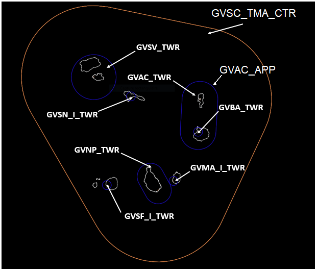
¶ Horizontal sectorizations, TMA and CTR
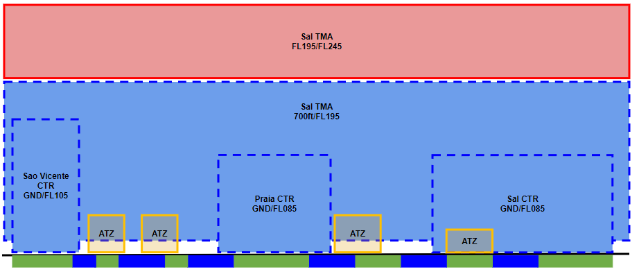
¶ Vertical sectorizations, TMA and CTR
| Name (Languages) |
Lateral limits | Vertical limits | Aeras and conditions | Callsigns Frequencies |
|---|---|---|---|---|
| Amilcabral ATZ (English, Portuguese) |
See Annex 1 | GND/1500ft | ATZ C airspace |
Amilcabral Tower GVAC_TWR 119.700 MHZ |
| Sal TMA (English, Portuguese) |
700ft/FL195 | TMA C airspace |
Sal Approach GVSC_TMA_CTR 127.100 MHZ |
|
| FL195/FL245 | TMA A airspace |
|||
| Boavista ATZ (English, Portuguese) |
GND/1500ft | CTR C airspace |
Boavista Tower GVBA_CTR 118.900 MHZ |
|
| Maio ATZ (English, Portuguese) |
GND/2000ft | ATZ G airspace |
Maio Information GVMA_I_TWR 118.500 MHZ |
|
| Sal CTR (English, Portuguese) |
GND/FL085 | CTR C airspace |
Sal Approach GVAC_APP 126.400 MHZ |
|
| Praia CTR (English, Portuguese) |
GND/FL085 | CTR C airspace |
Praia Tower GVNP_TWR 118.200 MHZ |
|
| SanFilipe ATZ (English, Portuguese) |
GND/2000ft | ATZ G airspace |
SanFilipe Information GVSF_I_TWR 118.600 MHZ |
|
| Sanicolau ATZ (English, Portuguese) |
GND/2000ft | ATZ G airspace |
Sanicolau Information GVSN_I_TWR 118.700 MHZ |
|
| Sao Vicente CTR (English, Portuguese) |
GND/FL105 | CTR C airspace |
Sao Vicente Tower GVSV_TWR 118.400 MHZ |
¶ Horizontal sectorizations, FIR, CTA, UIR
Below, the sectors adjacent to the Sal Oceanic FIR.
| Name (languages) | Callsign | Frequencies |
|---|---|---|
| Dakar Oceanic FIR (English, French) |
GOOO-CTR (Dakar Oceanic) |
128.900 MHZ |
| Santa Maria Oceanic FIR (English, Portuguese) |
LPPO_OCC_CTR (Santa Maria Oceanic) |
133.550 MHZ |
| Canarias FIR (English, Spanish) |
GCCC_OCE_CTR (Canarias Control) | 133.000 MHZ |
| Dakar FIR (English, French) |
GOOT_CTR (Dakar Control) |
129.500 MHZ |
According to the previous table, here is the representation of the Sal Oceanic FIR airspace.
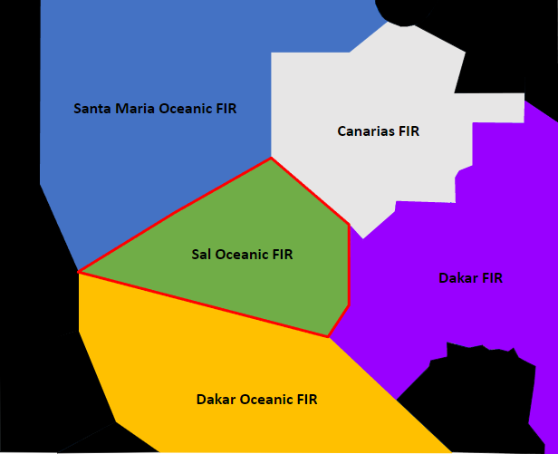
Without validated unbundling, only the GVSC_CTR sector is open on the 128.300 MHZ frequency. The en-route sector (GVSC_CTR) is fully responsible for the Sal Oceanic FIR.
Please note that specific skills are required to open the Sal Control. The particularities of the EUR/SAM corridors are detailed at this link.
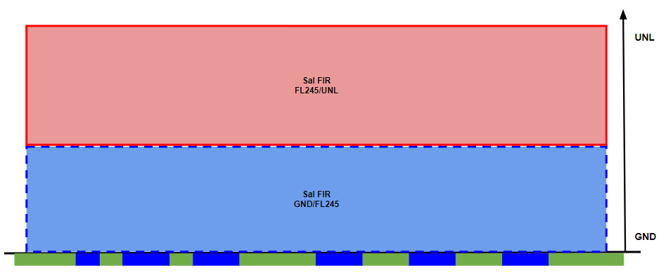
¶ Vertical sectorizations, FIR, CTA, UIR
| Name (Language) |
Lateral limits |
Vertical limits |
Areas and conditions | Callsigns and Frequencies |
|---|---|---|---|---|
| Sal Oceanic FIR (English, Portuguese) |
See Annex 1 | FL245/UNL | FIR A airspace |
Sal Control GVSC_CTR 128.300 MHZ |
| GND/FL245 | FIR C airspace |
|||
| FL195/UNL | ATS Route A airspace |
|||
| GND/FL195 | ATS Route C airspace |
¶ ATS routes
¶ Lower ATS routes
This section details only the routes in the lower airspace.
| Designation of the route | Level | Route designation (FIX)* | Observation |
|---|---|---|---|
| A602 | "The levels and parities of the routes are not available" | CVS ⇆ MOGSA | C and A airspaces FL245/MEA |
| B623 | Detailed information in the "EUR/SAM Corridor" section | IPERA ⇆ ONOBI | |
| R976 | "The levels and parities of the routes are not available" | SAL ⇆ LUMPO | |
| W11 | SAL ⇆ PINPO | ||
| W12 | SNT ⇆ CVS | ||
| W13 | BULVA ⇆ SVT | ||
| W14 | SVT ⇆ SAL | ||
| W15 | KESIK ⇆ SAL | ||
| W21 | BVT ⇆ PISPU | ||
| W22 | BVT ⇆ PINPO | ||
| W23 | SNT ⇆ BVT | ||
| W31 | SNT ⇆ MOGSA | ||
| W32 | SNT ⇆ BORTA | ||
| W33 | AGTIL ⇆ SNT | ||
| W34 | BULVA ⇆ SNT | ||
| W35 | SVT ⇆ SNT | ||
| W41 | LININ → SVT | ||
| W42 | SVT → MOPAC | ||
| W43 | NOMDO ⇆ SVT | ||
| W45 | DENER → SVT | ||
| W46 | SVT → EDIPA | ||
| W47 | EVKAS ⇆ SVT |
The airways sections W41, W42, W45 and W46 are only used in one direction.
*This column informs only the two points at the ends of the route.
¶ Upper ATS routes
This section details only the routes in the upper airspace.
| Designation of the route | Level | Route designation (FIX)* | Observation |
|---|---|---|---|
| UA602 | "The levels and parities of the routes are not available" | CVS ⇆ MOGSA | A airspace UNL/FL245 |
| UB623 | Detailed information in the "EUR/SAM Corridor" section | ||
| UN741 | Detailed information in the "EUR/SAM Corridor" section | ||
| UN857 | Detailed information in the "EUR/SAM Corridor" section | ||
| UN866 | Detailed information in the "EUR/SAM Corridor" section | ||
| UN873 | Detailed information in the "EUR/SAM Corridor" section | ||
| UR976 | "The levels and parities of the routes are not available" | ULTEM ⇆ LUMPO | |
| UW11 | CVS ⇆ PINPO | ||
| UW21 | BVT ⇆ PISPU | ||
| UW22 | BVT ⇆ PINPO | ||
| UW23 | SNT ⇆ BVT | ||
| UW31 | SNT ⇆ MOGSA | ||
| UW32 | SNT ⇆ BORTA | ||
| UW33 | AGTIL ⇆ SNT | ||
| UW34 | BULVO ⇆ SNT | ||
| UW35 | SVT ⇆ SNT | ||
| UW41 | EDUMO → SVT | ||
| UW42 | SVT → MOPAC | ||
| UW43 | SVT ⇆ IPERA | ||
| UW45 | DENER → SVT | ||
| UW46 | SVT → KENOX | ||
| UW47 | ULTEM ⇆ SVT | ||
The airways sections UW41, UW42, UW45 and UW46 are only used in one direction.
*This column informs only the two points at the ends of the route.
All specific procedures for the management of navigation in the EUR/SAM corridors are detailed in this link
¶ EUR/SAM Corridor
For information, here is a schematic representation of the EUR/SAM corridors.
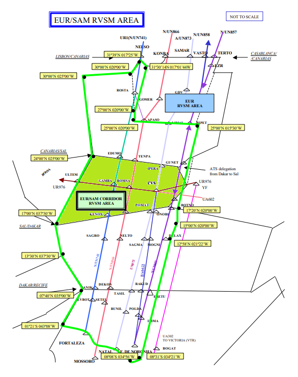
The airways concerned and used are (in the airspace of Sal Oceanic FIR):
| Airways | Level | FIX | Remarks |
|---|---|---|---|
| UN741 | All flight levels (even and odd) between FL245 and UNL are used by southbound traffic | EDUMO GAMBA KENOX |
Unidirectional north-south ATS route |
| UN866 | All flight levels (even and odd) between FL245 and UNL are used by northbound traffic | AMDOL IREDO TENPA |
Unidirectional south-north ATS route |
| UN873 | All flight levels between FL245 and UNL are used in accordance with the semi-circular rule | IPERA CVS POMAT |
Two way ATS route |
| UB623 | All flight levels between FL245 and FL280 are used in accordance with the semi-circular rule | CVS ONOBI |
Conventional airway Two way ATS route |
| UN857 | All flight levels between FL245 and UNL are used in accordance with the semi-circular rule | GUNET ORABI BOTNO |
Two way ATS route |
| B623 | All flight levels between 3000ft and FL245 are used in accordance with the semi-circular rule | IPERA PISPU CVS AGTIL ONOBI |
Conventional airway Two way ATS route |
All management procedures and coordination between adjacent airspaces are detailed in this link.
¶ Radio navigation aids/systems en-route
| Name of station | ID | Frequencies | Coordinates | Elevation |
|---|---|---|---|---|
| Sal VOR/DME |
CVS | 115.300 MHZ | 16°44'12.0"N 022°57'3.7"W | 196ft |
| Boa Vista NDB |
BVT | 341.000 KHZ | 16°8'3.4"N 022°53'17.0"W | / |
| Sao Vicente NDB |
SVT | 333.000 KHZ | 16°49'45.0"N 025°3'52.6"W | / |
| Praia VOR/DME |
SNT | 116.600 MHZ | 14°56'20.7"N 023°28'55.6"W | 333ft |
¶ Navigation warnings
¶ Prohibited areas
-Not available-
¶ Restricted areas
-Not available-
¶ Danger areas
-Not available-
¶ Aerodromes (AD)
¶ Sal Amilcar Cabral Airport - GVAC
¶ Airport Information
| Informations | |
|---|---|
| ICAO Code | GVAC |
| IATA Code | SID |
| Airport name | Sal Amilcar Cabral International Airport |
| Time zone conversion | UTC -1 |
| Coordinates of the reference point and location of the airfield |
16°44'15.32 N 022°57'00.06 W |
| Direction and distance from (city) | South 3km from Espargos city |
| Altitude / temperature reference | 56m (184feet) / 27.4°C |
| Magnetic declination | 10° W |
| Permitted traffic types | IFR / VFR |
| Runway | 01 / 19 |
¶ Characteristic of the runway
The runway 01-19 has the following features:
| Description of the runway | Runway 01 | Runway 19 |
|---|---|---|
| Dimensions of runway (m) | 3000 x 45 | 3000 x 45 |
| True and Mag Brg | 359° True | 179° True |
| Strength (PCN) and surface of runway | 58/F/A/W/U Asphalt | |
| Threshold coordinates | 16°43'26.23 N 022°56'55.92 W | 16°45'03.83 N 022°56'56.60 W |
| Threshold elevation | Threshold 56.19m (184.34ft) | Threshold 53.50m (175.51ft) |
| TORA (m) | 3000 | 3000 |
| TODA (m) | 3300 | 3300 |
| ASDA (m) | 3000 | 3000 |
| LDA (m) | 3000 | 3000 |
¶ ATS Communication facilities
| Designation service | Call sign | Frequency |
|---|---|---|
| Approach | Sal Approach (GVAC_APP) |
126.400 MHZ |
| Tower | Amicabral Tower (GVAC_TWR) |
119.700 MHZ |
¶ Radio navigation and landing aids
| Type of aid | ID | Frequency | Informations |
|---|---|---|---|
| VOR/DME | CVS | 115.300 MHZ | 16°44'12.37 N 022°57'03.78 W |
| ILS | SL | 109.900 MHZ | 011° |
¶ Local airport regulation
¶ Automatic Terminal Information Service
The ATIS must be completed in English.
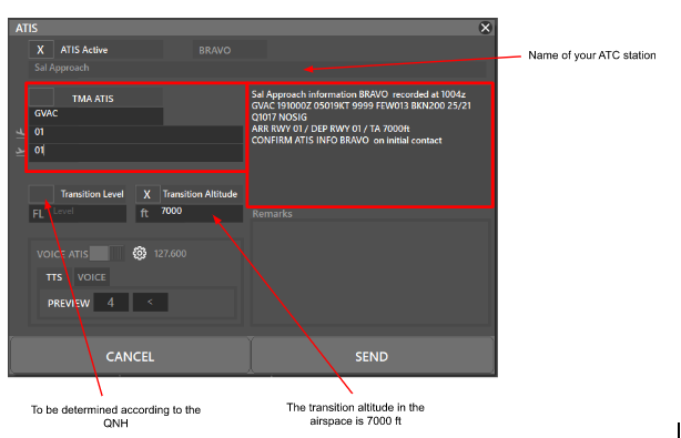
At the beginning of the session, please fill out the ATIS correctly. The transition altitude (TA) is 7000ft. The transition level (TL) is to be determined according to the QNH.
There is no preferential runway, however an ILS procedure is available on runway 01. Any special information can be marked in the "remarks" box.
| ATIS station | Frequency |
|---|---|
| Amilcar Cabral | 127.600 MHZ |
¶ Traffic areas
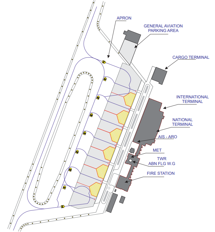
The Tower will assign a gate number to arriving aircraft. General aviation aircraft will be required to use their designated apron area.
¶ Aircraft gate management
Located in front of the terminal, the commercial aviation parking lot has 9 parking spaces for the different categories (see below).
| Gates | Airlines | Aircraft Types |
|---|---|---|
| 1A | Bestfly Cabo Verde | AT72 - E190 |
| 1 | ||
| 2 | ||
| 3 | LATAM Cargo | B767 |
| 4 | Edelweiss Air - Tui-Fly - LATAM Cargo | A320 - B737 - B767 |
| 5 | Tui-Fly - AlbaStar - Luxair | B38M - B737 |
| 6 | Cabo Verde Airlines - Transavia France TAP Air Portugal - Neos - Tui-Fly Enter Air - Smartwings Poland |
B737 - A320 |
| 7 | Sunclass Airlines | A321 - A330 |
| 7A | Bestfly Cabo Verde | AT72 - E190 |
¶ Squawk code
For better traffic management in the Cabo Verde airspace, here are the squawk codes to assign to traffic according to their destination.
| Flight | Code |
|---|---|
| Domestic IFR | 0500 - 0577 / 0600 - 0677 / 0700 - 0777 |
| Transit IFR | 3700 - 3777 |
| VFR | 1200 |
¶ Characteristics of the taxiways
| Taxiways description | Taxiway width (m) | Geographical coordinates of the appropriate axial points of the taxiways |
|---|---|---|
| A | 23 | 16°43'28.20 N - 022°56'48.79 W 16°44'56.90 N - 022°56'49.35 W |
| B | 16°43'50.48 N - 022°56'46.70 W 16°43'50.98 N - 022°56'45.88 W |
|
| C | 16°44'10.01 N - 022°56'48.04 W 16°44'09.91 N - 022°56'46.36 W |
|
| D | 16°44'32.55 N - 022°56'54.42 W 16°44'34.48 N - 022°56'51.21 W |
|
| E | 16°43'52.00 N - 022°56'45.32 W 16°44'08.22 N - 022°56'45.51 W |
|
| F | 43 | 16°43'23.93 N - 022°56'55.84 W 16°43'18.81 N - 022°56'55.84 W |
¶ CTR description
Amilcar Cabral airport has a class C CTR, starting from the surface, and going up to FL085.
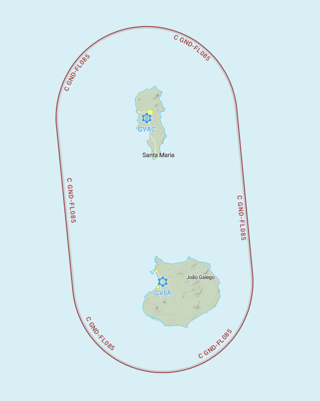
The traffic pattern is not published, however due to the configuration of the facilities, the western sector is preferred at 1200ft AMSL.
It was decided, in consultation with the ATC Operations Department, that the vertical limits of the CTR would be from the surface to 2500ft, within a 10 NM radius centred on the CVS VOR (115.300 MHZ).
¶ VFR entries, exits, transits in CTR
CTR entries and exits are normally made from the North and from the West after coordination with the approach controller. VFR transits will pass vertically from the airport at least 500ft above the aerodrome traffic patterns altitude.
¶ TMA area description
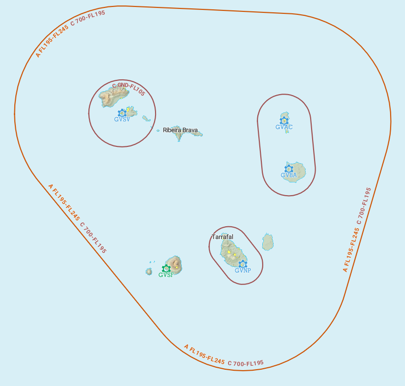
The control sector of Sal approach is divided into 2 TMA. The TMAs overlap (700ft to FL195 - C airspace and FL195 to FL245 - A airspace).
¶ Prohibited zone (TMA area)
-Not available-
¶ Standard instrument departure
| Runway | SID | RNAV or conventional | Altitude or FL |
|---|---|---|---|
| 01 | BULVO 1A | Conventional SID | - |
| BULVO 1K | 2000ft minimum | ||
| BVT 1A | 2500ft minimum at 6NM of CVS | ||
| KESIK 1A | 2000ft minimum | ||
| NCL 1A | |||
| PINPO 1A | 2500ft minimum at 6NM of CVS | ||
| PISPU 1A | |||
| POLMO 1A | |||
| RAMOL 1A | |||
| SNT 1A | 2000ft minimum | ||
| SNT 1K | |||
| SVT 1A | |||
| 19 | BULVO 1B | - | |
| KESIK 1B | - | ||
| NCL 1B | 2000ft minimum | ||
| PINPO 1B | - | ||
| PISPU 1B | - | ||
| POLMO 1B | - | ||
| RAMOL 1B | - | ||
| SNT 1B | - | ||
| SVT 1B | 2000ft minimum |
¶ Standard instrument terminal arrival
| Runway | STAR | Observations |
|---|---|---|
| All Runways | KESIK 1S | 2500ft minimum at CVS (115.3) IAF CVS |
| NINAU 1S | ||
| NCL 1S | ||
| BULVO 1S | ||
| AGTIL 1S | ||
| PISPU 1S | ||
| PINPO 1S | ||
| POLMO 1S | ||
| RAMOL 1S | ||
| SNT 1S |
¶ Instrument approach procedures
| Runway | Approach | IAF | FAF | Beacon |
|---|---|---|---|---|
| 01 | VOR ILS | CVS (115.3) | 9 NM of CVS 1500ft |
CVS 115.3 |
| VOR DME | 8 NM of CVS 1500ft |
CVS 115.3 | ||
| 19 | VOR DME | 8 NM of CVS 2400ft |
CVS 115.3 |
¶ Charts related to the aerodrome
Find the summary of the chart here
Please note that they might not be up-to-date !