Work In Progress
¶ Introduction
This OPMAN (Operation Manual) present all the air procedures and rules applicable in the airspace of Seychelles (FSSS FIR). In addition, the airport of Seychelles (FSIA) and Praslin (FSPP) are detailed (IFR and VFR procedures).
This document is the responsibility of the HQ ATC department. For any questions/comments, you can contact them via the following e-mail address : a-srdep@ivao.aero
National AIP link : https://www.scaa.sc/
¶ History of modifications
| version | Modifications | Validation month |
|---|---|---|
| 1/2022 | 2209 : Document creation | 09/2022 |
¶ Documentary organization
The OPMAN is divided into 4 parts :
- General rules and procedures (GEN),
This section will address national regulations and requirements, applicable units of measure, and services.
- En-route (ENR),
This section will cover ATS airspace, ATS routes, navigation aids and systems, and navigation hazards (P, R, D zones, ...).
- Aerodromes (AD).
This section will discuss aerodromes and heliports.
- Annex 1 (separate document) details the lateral boundaries of the FIR, TMA and CTR airspaces.
¶ General Rules and Procedures (GEN)
¶ Visual flight rules
Except for special VFR, VFR flights must be operated in conditions of visibility and distance from cloud.
VFR flight shall not be flown :
- over cities at a height of less than 300m (1000ft),
- at a height of less than 150m (500ft) above ground or water.
VFR flights shall not take off, land, and cross any airspace if :
- the ceiling is less than 450 M (1500 ft),
- the visibility is less than 5KM.
VFR flights are not allowed :
- above FL 200,
- at transonic and supersonic speeds,
- beyond 20 NM from shoreline.
Except for these areas, the overflight height must be 150m (500ft) above the ground, or ocean.
Unless otherwise authorized, the sending of a flight plan is mandatory. All boxes (1 to 18) must be completed.
¶ Instrument flight rules
An aircraft in IFR flight in the cruise phase within controlled airspace will use a cruise level. See Appendix 3 of ICAO Annex 2.
Aircraft in IFR flight, entering a control area to land, will be cleared to the specified holding point. They will receive instructions from the approach controller (time, level, next position). These instructions must be respected. Otherwise, the waiting procedure will be executed.
IFR departures from an uncontrolled aerodrome must contact the Area Control Center.
The Transition Altitude of Seychelles FIR is 4500 feet within 25 nm from the ARP of Seychelles and 3500ft beyond. The first usable flight level is FL060.
An IFR flight plan must be sent and completed.
Position report are mandatory within the Seychelles FIR, pilots shall report position as specified in 3.6.3 of ICAO Annex 2 for controlled flight.
¶ ATS airspace classification
ATS airspaces are classified and designated as detailed in ICAO Annex 11, Chapter 2.6. No specific rules are complementary
¶ Rules of the air
SSR equipment not existing on the Seychelles facilities, only ADS (Automatic Dependent Surveillance). The special measures
for this equipment are not taken into account.
Primary radars are unable to detect the altitude and speed of an aircraft.
The information given by the AURORA software is only a complementary tool to know the exact position of the aircraft. ATC manages the flow of traffic thanks to the pilots' position report (procedural control).
There is no published Minimum (Radar) Vectoring Altitude allowing air traffic management by "vectors". No heading can be provided to ensure safe obstacle clearance.
In the Terminal Control Area (TMA), in the Control Zone (CTR) position reports are mandatory for VFR flights.
¶ EN-ROUTE (ENR)
¶ ATS airspaces
¶ Horizontal sectorizations, TMA and CTR
See below the ATC frequencies and the different airspace classes.
¶ Vertical sectorizations, TMA and CTR
| Name (Languages) | Laterals limits | Verticals limits | Areas and conditions | Callsign and Frequencies |
|---|---|---|---|---|
| Seychelles CTA (English) | See Annex 1 | FL105 / FL145 | TMA A&D Airspace | Seychelles Approach FSIA_APP 119.700 MHz |
| Seychelles TMA - A (English) | See Annex 1 | 2000ft / FL075 | TMA D Airspace | Seychelles Approach FSIA_APP 119.700 MHz |
| Seychelles TMA - B (English) | See Annex 1 | 3500ft / FL075 | TMA D Airspace | Seychelles Approach FSIA_APP 119.700 MHz |
| Seychelles TMA - C (English) | See Annex 1 | FL075/ FL105 | TMA D Airspace | Seychelles Approach FSIA_APP 119.700 MHz |
| Seychelles CTR (English) | See Annex 1 | GND / 3500ft | CTR D Airspace | Seychelles Tower FSIA_TWR 118.300 MHz |
| Praslin CTR (English) | See Annex 1 | GND / 3500ft | CTR D Airspace | Praslin Tower FSPP_TWR 122.300 MHz |
¶ Horizontal sectorizations, FIR, CTA, UIR
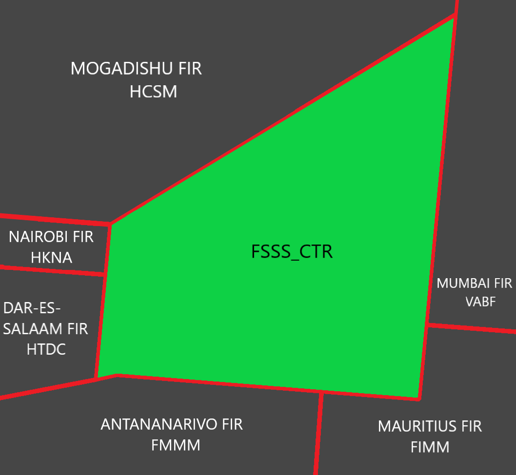
Below the sectors adjacent to the FIR of Mauritius
| Name (Languages) | Callsign | Frequencies |
|---|---|---|
| Seychelles FIR (English) | FSSS_CTR (Seychelles Control) | 120.100 MHz |
| Mogadishu FIR (English) | HCSM_FSS (Mogadishu Information) | 126.900 MHz |
| Nairobi FIR (English) | HKNA_CTR (Nairobi Center) | 121.300 MHz |
| Dar-Es-Salaam FIR (English) | HTDC_CTR (Dar Control) | 123.300 MHz |
| Antananarivo FIR (French, English) | FMMM_CTR (Antananarivo Control) | 128.900 MHz |
| Mauritius FIR (English) | FIMM_CTR (Mauritius Center) | 129.300 MHz |
| Mumbai FIR (English) | VABF_OC_CTR (Mumbai Radio) | 132.600 MHz |
¶ Vertical sectorizations, FIR, CTA, UIR
| Name (Languages) | Laterals limits | Verticals limits | Areas and conditions | Callsign and Frequencies |
|---|---|---|---|---|
| Seychelles FIR (English) | See Annex 1 | SFC / UNL | FIR A Airspace above FL145 |
Mauritius Center FSSS_CTR 120.200 MHz |
¶ ATS airspaces
¶ Lower ATS routes
This section details the routes in the upper and lower airspace.
| Designation of the route | Level | Route designation (FIX)° | Observation |
|---|---|---|---|
| N628 | Odd/Even | BUSUX ⇆ PRA | FL245 - - - FL065 |
| B459 | MIROV ⇆ CLAVA | ||
| G424 | ANVET ⇆ VUTAS | ||
| G465 | NESAM ⇆ OTKIR | ||
| L433 | KISAK ⇆ ATOLA | ||
| L434 | XABON ⇆ PRA | ||
| M311 | NETAR ⇆ PRA | ||
| M651 | ESTOK ⇆ PRA | ||
| M655 | ITLOX ⇆ ANKOR | ||
| R212 | PERRY ⇆ PRA | ||
| R400 | EGLOM ⇆ PRA | ||
| R400 | Even/Odd | PRA ⇆ ALRAN | |
| R401 | AXINA ⇆ AMBAN | ||
| R775 | Odd/Even | UNPAR ⇆ BERIL | |
| R780 | APKAK ⇆ DENLI | ||
| R782 | BERIL ⇆ PRA | ||
| W735 | AVIMO ⇆ PRA |
° this column informs only the two points at the ends of the route.
¶ Upper ATS routes
This section details the routes in the upper and lower airspace.
| Designation of the route | Level | Route designation (FIX)° | Observation |
|---|---|---|---|
| N628 | Odd/Even | BUSUX ⇆ PRA | UNL - - - FL245 |
| UB459 | MIROV ⇆ CLAVA | ||
| UG424 | ANVET ⇆ VUTAS | ||
| UG465 | NESAM ⇆ OTKIR | ||
| UL433 | KISAK ⇆ ATOLA | ||
| UL434 | XABON ⇆ PRA | ||
| UM311 | NETAR ⇆ PRA | ||
| UM651 | ESTOK ⇆ PRA | ||
| UM655 | ITLOX ⇆ ANKOR | ||
| UR212 | PERRY ⇆ PRA | ||
| UR400 | EGLOM ⇆ PRA | ||
| UR400 | Even/Odd | PRA ⇆ ALRAN | |
| UR401 | AXINA ⇆ AMBAN | ||
| UR775 | Odd/Even | UNPAR ⇆ BERIL | |
| UR780 | APKAK ⇆ DENLI | ||
| UR782 | BERIL ⇆ PRA | ||
| UW735 | AVIMO ⇆ PRA |
° this column informs only the two points at the ends of the route.
¶ Radio navigation aids/systems en-route
| Name of the station | ID | Frequency | Coordinates | Remarks |
|---|---|---|---|---|
| Praslin VOR/DME |
PRA | 115.700 MHZ | 04°18’26”S 055°42’25”E | / |
¶ Navigation warnings
¶ Prohibited areas
| Identification | Lower/Upper limits | Remarks | ||
|---|---|---|---|---|
| FS(P) – MONTAGNE POSEE PRISON (PROHIBITED) |
Ground | 3000ft AMSL | Prison | |
¶ Restricted areas
| Identification | Lower/Upper limits | Remarks | ||
|---|---|---|---|---|
| FS(R) – FREGATE ISLAND (RESTRICTED) |
Ground | 2000ft AMSL | No flight within this area except with special permission from the Director of Civil Aviation |
|
| FS(R) – COUSIN ISLAND (RESTRICTED) |
Ground | 2000ft AMSL | Bird Sanctuary | |
| FS(R) – ARIDE ISLAND (RESTRICTED) |
Ground | 2000ft AMSL | ||
| FS(R) – BIRD ISLAND (RESTRICTED) |
Ground | 2000ft AMSL | ||
| FS(R) – FSIA (RESTRICTED) |
Ground | 2000ft AMSL | National Assembly Building | |
¶ Danger areas
Non-existent
¶ AERODROMES (AD)
¶ Seychelles International Airport – FSIA
¶ Airport Information
| Informations | |
|---|---|
| ICAO Code | FSIA |
| IATA Code | SEZ |
| Airport name | Seychelles Intl. Airport (Seychelles) |
| Time zone conversion | UTC + 4 |
| Coordinates of the reference point and location of the airfield | 04° 40 27.64 S 055° 31 18.67 E |
| Direction and distance from (city) | 308° / 9.8km of Victoria |
| Altitude / temperature reference | 3.65m (12 feet) / 31.4°C |
| Magnetic declination | 5.37° W |
| Permitted traffic types | IFR / VFR |
| Runway | 13 / 31 |
¶ Characteristic of the runway
The runway 13-31 has the following features:
| Description of the runway | Runway 13 | Runway 31 |
|---|---|---|
| Dimensions of runway (m) | 2987 x 46 | 2987 x 46 |
| True and Mag Brg | 125° True / 130° Mag | 305° True / 310° Mag |
| Strength (PCN) and surface of runway | 72/R/B/W/U concrete | 72/R/B/W/U concrete |
| Threshold coordinates | 04°40’05.49 S 055°30’47.03 E | 04°40’49.78 S 055°31’50.30 E |
| Threshold elevation | Threshold 3.05m (10ft) | Threshold 3.05m (10ft) |
| TORA (m) | 2987 | 2987 |
| TODA (m) | 4480 | 3597 |
| ASDA (m) | 2987 | 2987 |
| LDA (m) | 2682 | 2682 |
¶ ATS Communication facilities
| Designation service | Callsign | Frequency |
|---|---|---|
| Center | Seychelles Control (FSSS_CTR) | 120.200 MHz |
| Approach | Seychelles Approach (FSIA_APP) | 119.700 MHZ |
| Tower | Seychelles Tower (FSIA_TWR) | 118.300 MHZ |
¶ Radio navigation and landing aids
| Type of aid | Callsign | Frequency | Informations |
|---|---|---|---|
| VOR/DME | PRA | 115.700 MHz | 04°18’26.52 S 055°42’25.44 E |
| ILS/DME | SIA | 110.300 MHz | 04°39’55.30 S 055°30’32.47 E |
¶ Local airports regulation
¶ Automatic Terminal Information Service
The ATIS must be completed in English
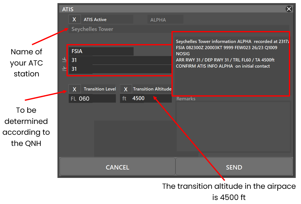
At the beginning of the session, please fill out the ATIS correctly. The transition altitude (TA) is 4500ft. The transition level (TL) is to be determined according to the QNH. The first usable level is FL060.
There is no preferential runway, however an ILS procedure is available on runway 31. Any special information can be marked in the "remarks" box.
| ATIS station | Frequency |
|---|---|
| Seychelles Intl. Airport | 131.600 MHZ |
¶ Traffic areas
The tower will assign a gate number to arriving aircraft. General aviation aircraft will be required to use their designated apron area.
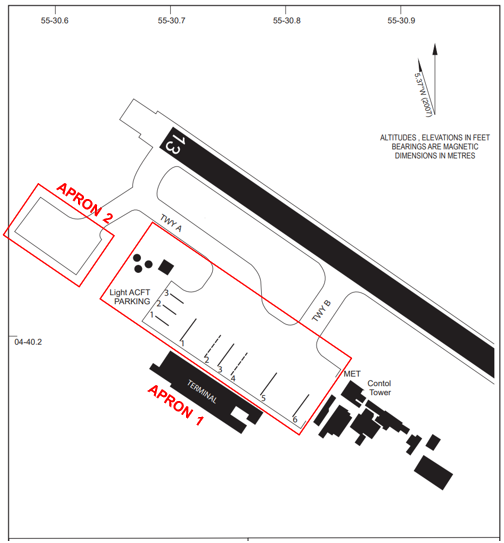
Apron 1 is intended for regular commercial aviation and general aviation, and Apron 2 for storage.
¶ Aircraft gate management
Located in front of the terminal (Apron 1), the commercial aviation parking lot has 6 parking spaces for the different categories (see below).
| Bay | Airlines | Aircraft types |
|---|---|---|
| 1 - 3 (Light) | Air Seychelles | DHC6 |
| 1 | Emirates | B77W |
| 2 | Kenya Airways | B738/E190 |
| 3 | Ethiopian Airlines – Air Austral | B738 – BCS3 |
| 4 | Air Seychelles | A20N |
| 5 | Etihad Airways – Qatar Airways – Turkish Airlines | A320 – B77L – A333 |
| 6 | Air Seychelles | A20N |
| STORAGE | All | All |
¶ Squawk code
For better traffic management in the Seychelles airspace, here are the squawk codes to assign to traffic according to their destination.
There is no radar installation inside the Seychelles FIR, all ATCs services are done procedurally, and squawk can stay on 2000 during the flight.
Position report are mandatory for IFR and VFR within the Seychelles FIR, pilots shall report their position as specified in 3.6.3 of ICAO Annex 2 for controlled flight.
| Flight | Code |
|---|---|
| Domestic IFR | 3000 – 3077 and 5700 – 5777 and 3100 – 3177 and 7001 - 7077 |
| Transit | 1600 - 1677 |
| VFR | 1200 |
¶ Characteristics of the taxiways
Please find bellow the different taxiway :
| Taxiways description | Traffic taxiways | ||
|---|---|---|---|
| Taxiway witdh (m) | Geographical coordinates of the appropriate axial points of the taxiways | ||
| A | 75 | 04°40’10 S - 055°30’43 E 04°40’01 S - 055°30’38 E |
|
| B | 75 | 04°40’08 S - 055°30’49 E 04°40’12 S - 055°30’46 E |
|
¶ CTR description
Seychelles airport has a class D CTR, starting from the surface, and going up to 2000 FT AMSL. There is no P area are located inside the CTR, and the aerodrome traffic circuit is not published.
¶ VFR entries, exits, transits in CTR
ATC Discretion
¶ TMA area description
The control sector of Seychelles represents 3 TMA and 1 CTA. The responsible ATC station is the Seychelles approach.
¶ Prohibited areas
There are no prohibited areas within the TMA of Seychelles
¶ Restricted areas
There are no danger areas within the TMA of Seychelles
¶ Danger areas
There are no restricted areas within the TMA of Seychelles
¶ Standard instrument departure
| Runway | RNAV or conventional SID | Altitude or FL | |
|---|---|---|---|
| 13 (RNAV) | NESID 1B | RNAV | To be determinated by ATC |
| OKLIM 1B | |||
| NEVIN 1B | |||
| TILOM 1B | |||
| UTALI 1B | |||
| LYNDY 1C | 1500 ft MAX | ||
| PAOLO 1C | |||
| PAOLO 1B | |||
| SAVVY 1B | |||
| 31 (RNAV) | ROUTY 1A | RNAV | To be determinated by ATC |
| UTALI 1A | |||
| IMPOX 1A | |||
| UNBED 1A | |||
| LYNDY 1C | 1500 ft MAX | ||
| PAOLO 1B | |||
| PAOLO 1C | |||
| SAVVY 1B | |||
¶ Standard instrument terminal arrival
| Runway | STAR | Observations |
|---|---|---|
| RWY 13 (RNP 1 REQUIRED) (GNSS REQUIRED) |
ROUTY 1D UNBED 1D UTALI 1D |
250kt maximum on MALON (IAF) 4500ft at MALON or above |
| IMPOX 1R | 210kt maximum on LIZZY (IAF) FL120 at FS700 or below |
|
| RWY 31 (RNP 1 REQUIRED) (GNSS REQUIRED) |
NESID 1E OKLIM 1E |
250kt maximum on DAVID (IAF) 4500ft at DAVID or above |
| NEVIN 1E UTALI 1E |
250kt maximum on PETER (IAF) 4500ft at PETER or above |
|
| TILOM 1E | 250kt maximum on SAMES (IAF) 4500ft at SAMES or above |
¶ Instrument approach procedures
| Runway | Approach | IAF | FAF | Beacon |
|---|---|---|---|---|
| 13 | RNP X | LIZZY / FOCKY / MALON | TERRY (2500ft) |
/ |
| RNP (AR) | LIZZY / MALON | FREDY (2200ft) |
/ | |
| 32 | ILS Z | PETER / SAMES / DAVID | DALON (2000ft) |
SIA (110.3) |
| ILS Z | PETER / SAMES / DAVID | DALON (2000ft) |
SIA (110.3) | |
| RNP Y | JERAD / LUWIE / DAVID | JUDDY (2500ft) |
/ | |
| RNP (AR) | PETER / SAMES / DAVID | DALON (2500ft) |
/ |
¶ Praslin Airport – FSPP
¶ Airport Information
| Informations | |
|---|---|
| ICAO Code | FSPP |
| IATA Code | PRI |
| Airport name | Praslin Airport (Seychelles) |
| Time zone conversion | UTC + 4 |
| Coordinates of the reference point and location of the airfield | 04° 19’ 09.27 S 055° 41’ 29.78 E |
| Direction and distance from (city) | 045° / 46km of Victoria |
| Altitude / temperature reference | 3.05m (10 feet) / 31.3°C |
| Magnetic declination | 5° W |
| Permitted traffic types | IFR / VFR |
| Runway | 15 / 33 |
¶ Characteristic of the runway
The runway 15-33 has the following features:
| Description of the runway | Runway 15 | Runway 33 |
|---|---|---|
| Dimensions of runway (m) | 1405 x 30 | 1405 x 30 |
| True and Mag Brg | 149° True / 154° Mag | 329° True / 334° Mag |
| Strength (PCN) and surface of runway | concrete | concrete |
| Threshold coordinates | 04°18’55.40 S 055°41’21.49 E | 04°19’26.65 S 055°41’40.17 E |
| Threshold elevation | Threshold 3.05m (10ft) | Threshold 3.05m (10ft) |
| TORA (m) | 1316 | 1094 |
| TODA (m) | 1316 | 1094 |
| ASDA (m) | 1316 | 1316 |
| LDA (m) | 1110 | 1238 |
¶ ATS Communication facilities
| Designation service | Callsign | Frequency |
|---|---|---|
| Approach | Seychelles Approach (FSIA_APP) | 119.700 MHZ |
| Tower | Praslin Tower (FSPP_TWR) | 122.300 MHZ |
¶ Radio navigation and landing aids
| Type of aid | Callsign | Frequency | Informations | |
|---|---|---|---|---|
| VOR/DME | PRA | 115.700 MHz | 04°18’26.52 S 055°42’25.44 E |  |
¶ Local airports regulation
¶ Automatic Terminal Information Service
The ATIS must be completed in English
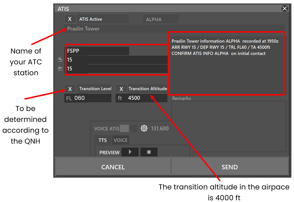
At the beginning of the session, please fill out the ATIS correctly. The transition altitude (TA) is 4500ft. The transition level (TL) is to be determined according to the QNH. The first usable level is FL60.
There is no preferential runway, and both runways have the same type of approaches
| ATIS station | Frequency |
|---|---|
| Seychelles Intl. Airport | 131.600 MHZ |
¶ Traffic areas
The tower will assign a gate number to arriving aircraft. General aviation aircraft will be required to use their designated apron area.
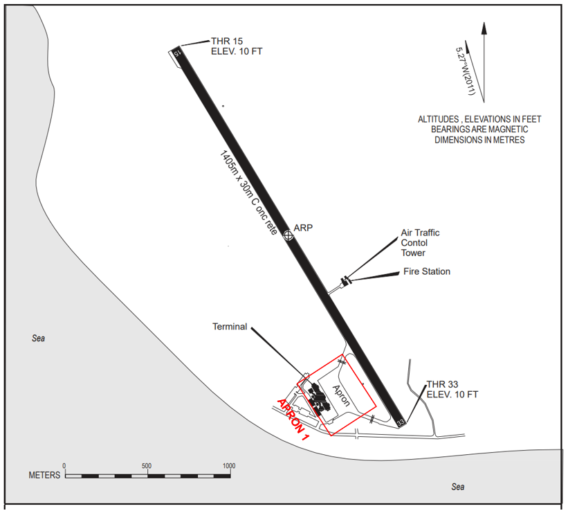
¶ Aircraft gate management
Located in front of the terminal the commercial aviation parking lot has 2 parking spaces for the different categories (see below).
| Bay | Airlines | Aircraft types |
|---|---|---|
| APN | Air Seychelles | DHC6 |
¶ Squawk code
For better traffic management in the Seychelles airspace, here are the squawk codes to assign to traffic according to their destination.
There is no radar installation inside the Seychelles FIR, all ATCs services are done procedurally, and squawk can stay on 2000 during the flight.
Position report are mandatory for IFR and VFR within the Seychelles FIR, pilots shall report their position as specified in 3.6.3 of ICAO Annex 2 for controlled flight.
| Flight | Code |
|---|---|
| Domestic IFR | 3000 – 3077 and 5700 – 5777 and 3100 – 3177 and 7001 - 7077 |
| Transit | 1600 - 1677 |
| VFR | 1200 |
¶ Characteristics of the taxiways
Please find bellow the different taxiway :
| Taxiways description | Traffic taxiways | ||
|---|---|---|---|
| Taxiway witdh (m) | Geographical coordinates of the appropriate axial points of the taxiways | ||
| Taxiway 1 | 10 | 04°19’28 S - 055°39’27 E 04°19’27 S - 055°36’73 E |
|
| Taxiway 2 | 10 | 04°19’20 S - 055°41’35 E 04°19’23 S - 055°41’34 E |
|
¶ CTR description
Praslin airport has a class D CTR, starting from the surface, and going up to 2000 FT AMSL. There one R area are located inside the CTR, and the aerodrome traffic circuit is not published.
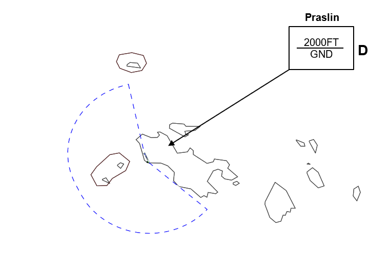
¶ VFR entries, exits, transits in CTR
ATC Discretion
¶ Standard instrument departure
| Runway | RNAV or conventional SID | Altitude or FL | |
|---|---|---|---|
| 15 (RNAV) | MALON 1E | CONV | 2500ft MAX |
| SAVVY 1E | 1500ft MAX | ||
| 33 (RNAV) | PETER 1D | 2500ft MAX | |
| SAVVY 1D | 1500ft MAX | ||
¶ Instrument approach procedures
| Runway | Approach | IAF | FAF | Beacon |
|---|---|---|---|---|
| 15 | RNP | TEDDY / LYNDY | PP407 (1800ft) |
/ |
| 33 | RNP | SAVVY / HENRY | PP404 (1700ft) |
/ |
| 15 / 33 | RNP A | RANDY / PAOLO | PP401 (2000ft) |
/ |
| VOR A | PRA | DME 6.5 BRG 195° OUT PRA 1500ft | PRA (115.7) | |
| VOR B | PRA | DME 6.5 BRG 195° OUT PRA 1500ft | PRA (115.7) | |
| VOR C | PRA | DME 6.5 BRG 195° OUT PRA 1500ft | PRA (115.7) |