¶ HQ Sectorfiles Quality
The following standards are the result of ample experiences creating Sectorfiles across the globe and tailoring them after real sessions. Our main goals are to ease informations acces, efficient use of space and avoiding cluttering.
Some of this guidelines might not be applicable in your case. Do not hesitate to contact us for suggestions or help.
The following criteria are mandatory for HQ airspace SectorFiles contributions.
Should you like to help us improve any SectorFiles accross the globe, please get in touch.
Disclaimer ! These guidelines are no in remplacement of the SectorFile Creation Manual but only the proper way to edit SectorFiles using the manual above for HQ FIR.
If any question or help is needed, contact the AO HQ Departement : a-srdep@ivao.aero
¶ SectorFiles Organisation
Sectorfiles have to be packed as .zip files. As soon as the .zip is opened, at least one .isc file and the Include folder must be visible. Inside Include folder, place a folder name ZZZZ, where ZZZZ match the ICAO of the FIR, containing the subfiles.
The .isc file should make it easy for users to find the SectorFile. Use the following format : ZZZZ - Name FIR.isc (where ZZZZ match the ICAO code of the FIR or an airport).
For HQ SectorFiles, we use this subfolder organisation :

Keep in mind that any changes to Sectorfile organisation should be followed by an update : .upd file that removes files from their old locations.
In order to help you, find an empty .zip file to help you using the HQ wanted format available to download here.
¶ Data importation
donnée geo
donnée airac
¶ Changelog
The ChangeLog.txt is a very important file, as it will help to manage and follow the update of a sector (No SectorFiles for HQ Airspace will be approved without a complete changelog edited !).
To ensure common edit and lecture of this file, please use the following .txt given (also available inside the .zip given above) : Changelog.txt
- The first part will be the identification of the changelog, with the FIR Name, date of update and AIRAC used :
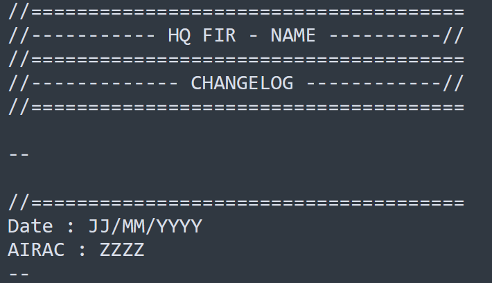
Here, don't forget to change “NAME”, by the name of the FIR you are working on, eg : “ANTANANARIVO”.
Then filed the date of released of your work and the AIRAC number used, eg “Date : 01/01/2024 - AIRAC 2313”.
- The second parts will cover all the added, removed, and updates files :
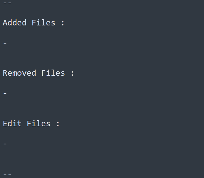
Here, simply short all the files according to the actions done, use the complete file name for that, eg : “Added Files : - FMMM.artcc”.
- The third and last parts, will describe with precision the updated given :
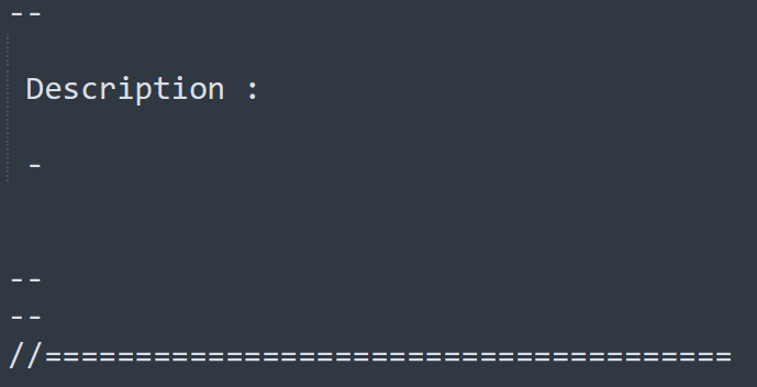
Do not hesitate to use complete sentence, the goal with this part is to have a clear representation of every edit made, even minor. This will help ATC Advisor when checking the update, and for futur edition, to know what has been done in the past, eg : “ - Complete update of the ground at Antananarivo airport, adding gates and taxiways labels.”.
¶ Files Format
¶ GEN
¶ ISC
Find de .isc canva to use here (also available in the .zip given above).
Regarding the canva, it is important to separate your SectorFile into two subfolder (ENR and AD), subfolder to be declared in the .isc.
We highly recommand using the DMS coordinates format : N000.00.00.000;W000.00.00.000;
Once finished, delete all the beacon not used eg : [FILLCOLOR]
¶ ATC
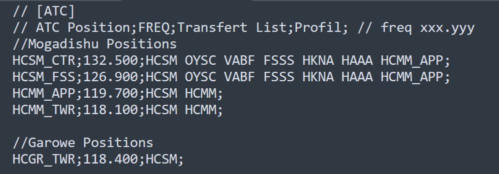
In this file, we will only use the two first parameters, we do not impose the profil, it is up to the user.
Each positions group will be separated and named using "//" eg : //Mogadishu Positions.
Positions will be short with the higher on top, going down to the lower position : _CTR ; _FSS ; _MIL _ ; _APP ; _DEP ; _TWR ; _I_TWR ; _GND ; _DEL
For the transfer list :
- CCR ; FSS and MIL_CTR Positions will have all the adjacents ICAO FIR code + ICAO_APP which the CCR is responsable of + any additionnal ICAO airport managed, not cover by an _APP.
- APP and DEP Positions will have the ICAO FIR code of its own FIR + ICAO of its own airport + ICAO of other managed airports.
- TWR ; _I_TWR ; _GND and _DEL Positions will have the ICAO FIR code of its own FIR + ICAO of its own airport.
Exemple :
¶ ATIS
This file should be present in order to have the stanard ATIS set for all position within the FIR, simply use the one in the .zip given above, and replace the ZZZZ with the ICAO of the FIR, eg : FIMM.atis
¶ ENR
¶ [GEO] Geopgraphic
This file is free for the editor to complete, you can use NGDC Geographic export for this, procedure is explain in the Aurora IVAO Builder.
¶ [APT] Airport
This file should contain both, inside and outside FIR airports, the first section will cover the inside FIR airports, and therefor should be display on Aurora using ;1; as the second section, will use ;2; to display the outside airport on the scope of Aurora, but not inside the AIRPORT menu.
Exemple :

¶ [RWY] Runway
This file should countain only the inside FIR runways, excepted if they are relevant.
Exemple :

¶ [VOR] VHF Omnidirectional Range
This file should countain inside FIR VOR + Outside VOR if their are relevant. Both section will be separated, but only the inside VOR should be shown using ;0; outside VOR will have ;1; (exception can be done if outside VOR are close [within 5nm] to the FIR border).
Exemple :

¶ [NDB] Non Directional Beacon
This file should countain inside FIR NDB + Outside NDB if their are relevant. Both section will be separated, but only the inside NDB should be shown using ;0; outside NDB will have ;1; (exception can be done if outside VOR are close [within 5nm] to the FIR border).

¶ [LAWY] Low Airway
This file should contain the declared lower airways of the eAIP, including tracks, waypoints and labels.
We recommand importing these data via the IAB, using "Lat/Long bounds" and a larger perimeter than the FIR one, to englobe a large portions of the airways, and have a better display on Aurora.
¶ [HAWY] High Airway
This file should contain the declared upper airways of the eAIP, including tracks, waypoints and labels.
We recommand importing these data via the IAB, using "Lat/Long bounds" and a larger perimeter than the FIR one, to englobe a large portions of the airways, and have a better display on Aurora.
¶ [ARTCC] Airspace
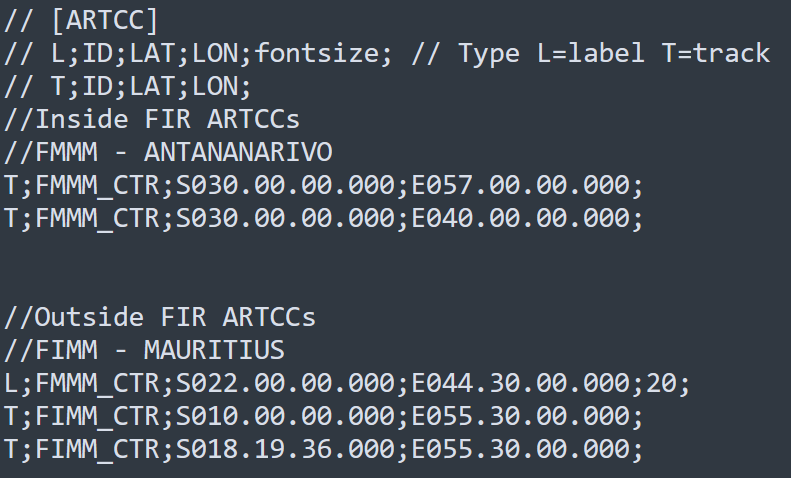
This file should coutain the laterals limits of the main FIR + the adjacents FIR, which will be the only one to have a label size : 20 .
¶ [LOW ARTCC] Low Airspace
This file should coutain all the CTR, RMZ, and/or TMZ of the FIR. Try to organise this file by sorting the different type of airspace from each other, keeping the CTR at the top/begining of the file then RMZ and TMZ.
If their are multiple upper airspace for a same airport, name them in the file according to the eAIP.

¶ [HIGH ARTCC] High Airspace
This file should coutain all the TMA, CTA, and/or FIS. Try to organise this file by sorting the different type of airspace from each other, keeping the TMA at the top/begining of the file then CTA and FIS.
If their are multiple lower airspace for a same airport, name them in the file according to the eAIP.

¶ [PROHIBIT] Prohibited area
This file should contain all the declared prohibited areas in the eAIP. If multiple, organize them increasingly.
Naming will be important, as it will helps ATC to display, or not, areas on Aurora, following the format : XX-P 00, where XX are the two first letter of the ICAO FIR, eg : HC-P 02

¶ [RESTRICT] Restricted area
This file should contain all the declared restricted areas in the eAIP. If multiple, organize them increasingly.
Naming will be important, as it will helps ATC to display, or not, areas on Aurora, following the format : XX-R 00, where XX are the two first letter of the ICAO FIR, eg : HC-R 02

¶ [DANGER] Danger area
This file should contain all the declared danger areas in the eAIP. If multiple, organize them increasingly.
Naming will be important, as it will helps ATC to display, or not, areas on Aurora, following the format : XX-D 00, where XX are the two first letter of the ICAO FIR, eg : HC-D 02

¶ [OTHER AREAS]
Other areas than R, P and D, are not planned to be cover inside Aurora SectorFiles, althouth, if they are relevant, HQ ATC can find a solution to add them on the SectorFiles, as well as in the DataBase to be display on webeye also.
¶ AD
¶ [GND] Ground - Geopgraphic
This file should be use to display ground layer, it can be either done via polygon, or predefine strip of Aurora, eg : ;RUNWAY;
¶ [GTS] Gate
This file should countain all the gates of an airport, coordinates should be set at a place where it is easily readable for the ATC.
¶ [MVA] Minimum Vector Altitude - Minimum Sector Altitude
This file should represent either the MVA if published on the eAIP, but MSA are allowed to be displayed in this section if no MVA exists.
¶ [SID] Standard Instrument Departure
/
¶ [STR] Standard Instrument Arrival
/
¶ [TXI] Taxiway
This file should countain all the taxiways of an airport, coordinates should be set at a place where it is easily readable for the ATC.
¶ [VFI] VFR Fixe
This file should countain all the VFR fixes published of an airport, coordinates should be set at a place where it is easily readable for the ATC.
¶ [VRT] VFR Route
This file should countain all the VFR routes published of a sector, coordinates should be set at a place where it is easily readable for the ATC.