¶ 1. ATS AIRSPACE
| Designation and Lateral Limits | Don Mueang Aerodrome Traffic Zone (ATZ) a circle, radius 5 NM centred on VTBD ARP (135452N 1003620E) |
| Vertical Limits | 2,000 ft / AGL |
| Airspace Classification | C |
| ATS Unit Callsign | Don Mueang Tower |
| Language(s) | English, Thai |
| Transition Altitude | 11,000 ft MSL |
¶ 2. RUNWAY
¶ 2.1. Runway Information
| Runway | True Bearing | Length and Width | Surface Type | TDZ - Elevation | Lighting |
|---|---|---|---|---|---|
| 03L | 029º | 3,700 m x 60 m | Asphalt Concrete | 7 ft | SALS, Centerline, Edge |
| 03R | 028º | 3,500 m x 45 m | Asphalt | 5 ft | SALS, Edge |
| 21L | 208º | 3,500 m x 45 m | Asphalt | 6 ft | CAT I, Edge |
| 21R | 209º | 3,700 m x 60 m | Asphalt Concrete | 7 ft | CAT II, Centerline, Edge, TDZ |
SALS - Short Approach Lighting System
TDZ - Touchdown Zone
Normally, commercial aircraft use 21R for departure and landing. Military and General Aviation use 21L.
In case of high traffic over the aerodrome, commercial aircraft can use 21L for departure via taxiway D or taxiway X
¶ 2.2. Runway Declared Distances
| DECLARED DISTANCES (Meters) | |||||
|---|---|---|---|---|---|
| Runway | TORA | TODA | ASDA | LDA | |
| 03L | 3,700 m | 3,850 m | 3,850 m | 3,700 m | |
| 03R | 3,500 m | 3,650 m | 3,500 m | 3,500 m | |
| 21L | 3,500 m | 3,650 m | 3,600 m | 3,150 m | |
| 21R | 3,700 m | 3,850 m | 3,850 m | 3,700 m | |
TORA - Takeoff Run Available
TODA - Takeoff Distance Available
ASDA - Accelerated Distance Stop Available
LDA - Landing Distance Available
¶ 2.3. Runway Intersection Distances
Departing aircraft will normally be directed by ATC to use the full length of the runway for take-off. Pilots may request or ATC may propose an intersection departure. The final decision whether to make an intersection departure rests with the pilot.
| TAKEOFF RUN AVAILABLE (TORA) RUNWAY 03L (Meters) | |
|---|---|
| C (South) | 3,700 m |
| S | 2,960 m |
| R | 2,540 m |
| TAKEOFF RUN AVAILABLE (TORA) RUNWAY 03R (Meters) | |
|---|---|
| Y | 3,500 m |
| S | 3,350 m |
| W | 2,650 m |
| TAKEOFF RUN AVAILABLE (TORA) RUNWAY 21L (Meters) | |
|---|---|
| X | 3,500 m |
| D | 3,150 m |
| U | 2,520 m |
| TAKEOFF RUN AVAILABLE (TORA) RUNWAY 21R (Meters) | |
|---|---|
| D, B (North) | 3,700 m |
| E | 3,220 m |
| F | 2,490 m |
¶ 3. ATS COMMUNICATION FACILITIES
¶ 3.1. Main ATS Communication Facilities
| Service Designation | Callsign | Frequency | Remarks |
|---|---|---|---|
| VTBD_DEL | Don Mueang Delivery | 127.700 MHz | - |
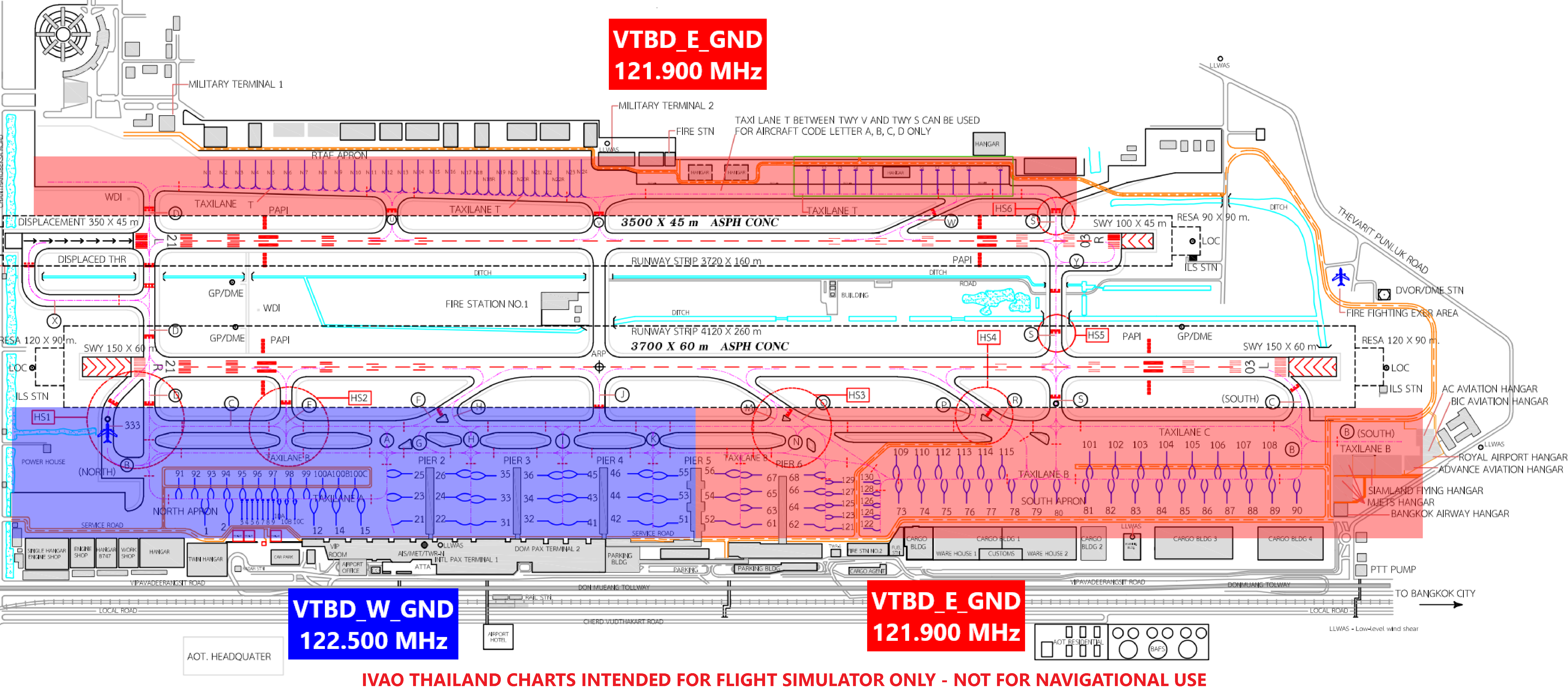
| VTBD_GND | Don Mueang Ground | 121.900 MHz | - |
| VTBD_TWR | Don Mueang Tower | 118.100 MHz | GND – ALT 2,000 ft |
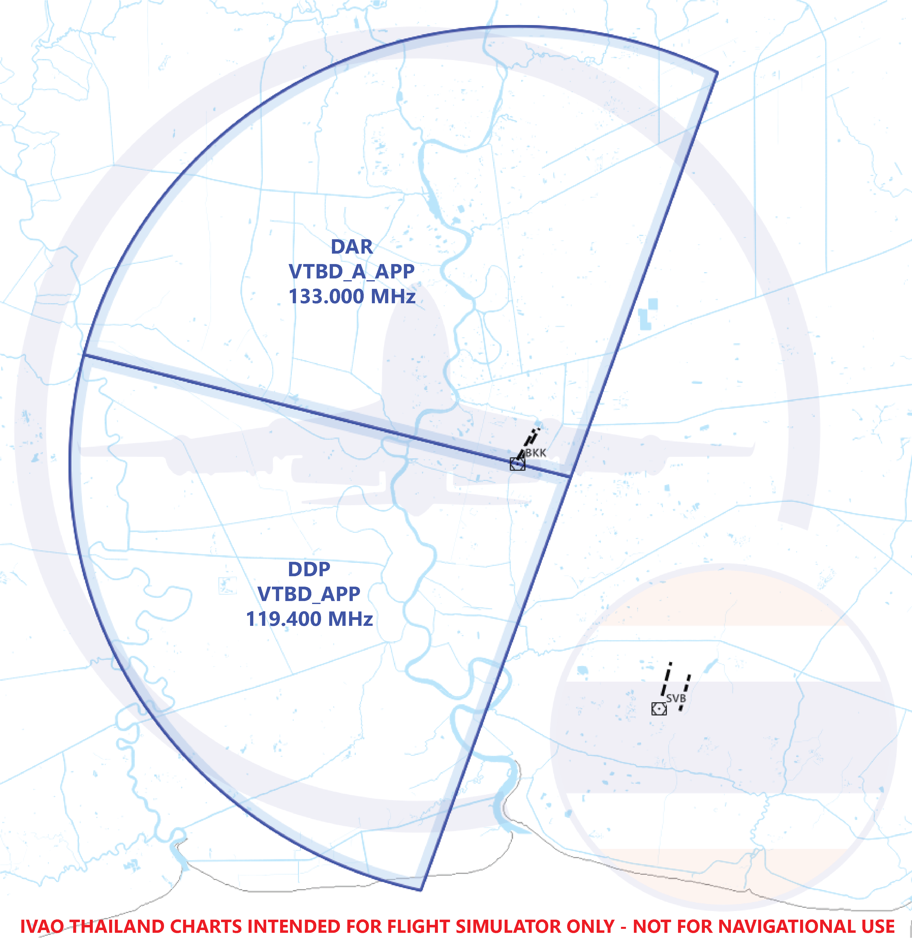
| VTBD_APP | Don Mueang Approach | 119.400 MHz | ALT 3,000 ft – 8,000 ft (In case of no VTBB_APP online upper limit may be increased to FL160) |
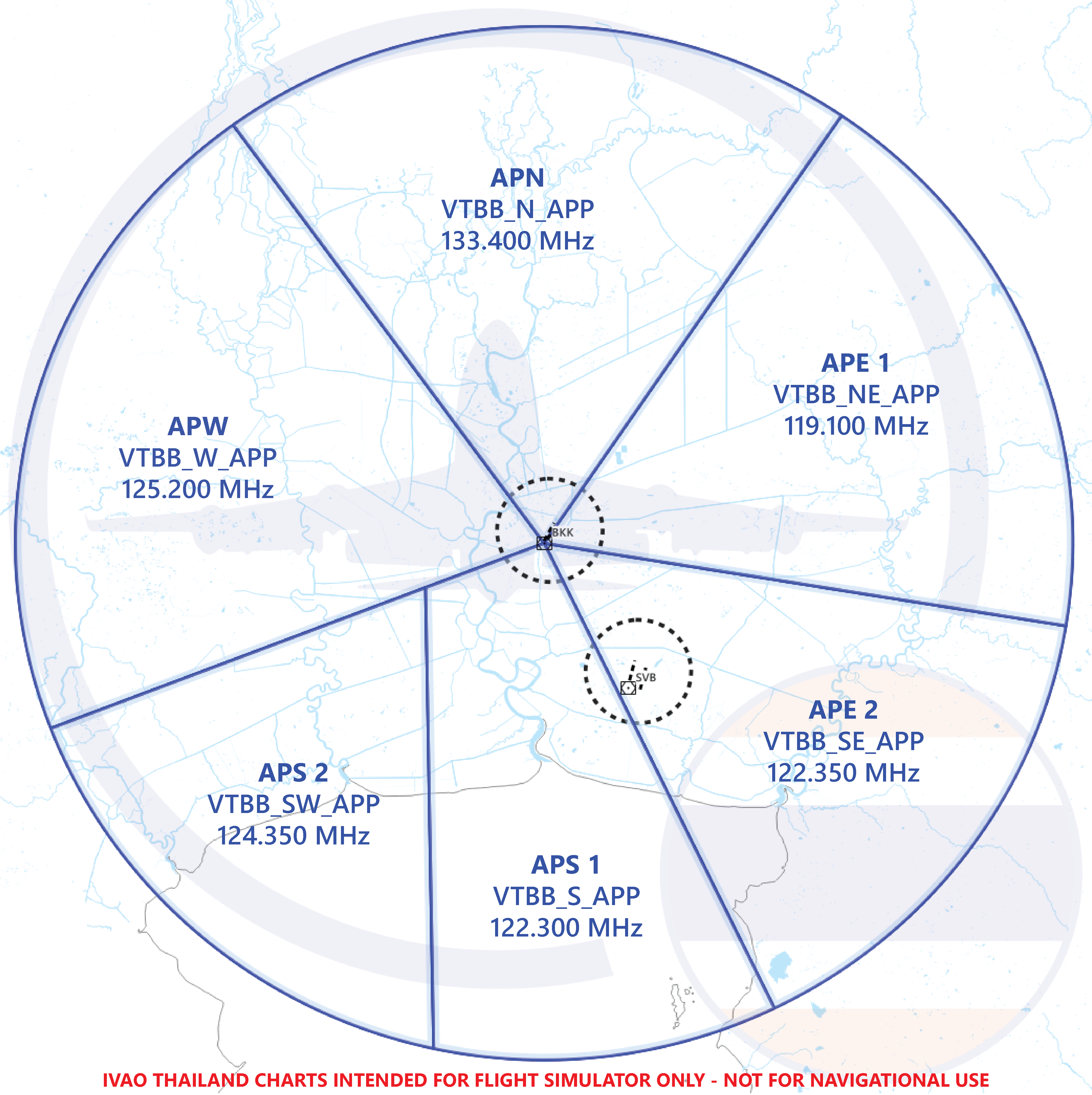
| VTBB_APP | Bangkok Approach | 125.200 MHz | ALT 3,000 ft – FL160 |
¶ 3.2. Full ATS Communication Facilities
| Service Designation | Callsign | Frequency | Remarks |
|---|---|---|---|
| VTBD_DEL | Don Mueang Delivery | 127.700 MHz | - |
| VTBD_E_GND | Don Mueang Ground | 121.900 MHz | East Side, Military Apron |
| VTBD_W_GND | Don Mueang Ground | 122.500 MHz | Civil Side, Include Taxiway K to Bay 51, 53, 55 |
| VTBD_TWR | Don Mueang Tower | 118.100 MHz | GND – ALT 2,000 ft |
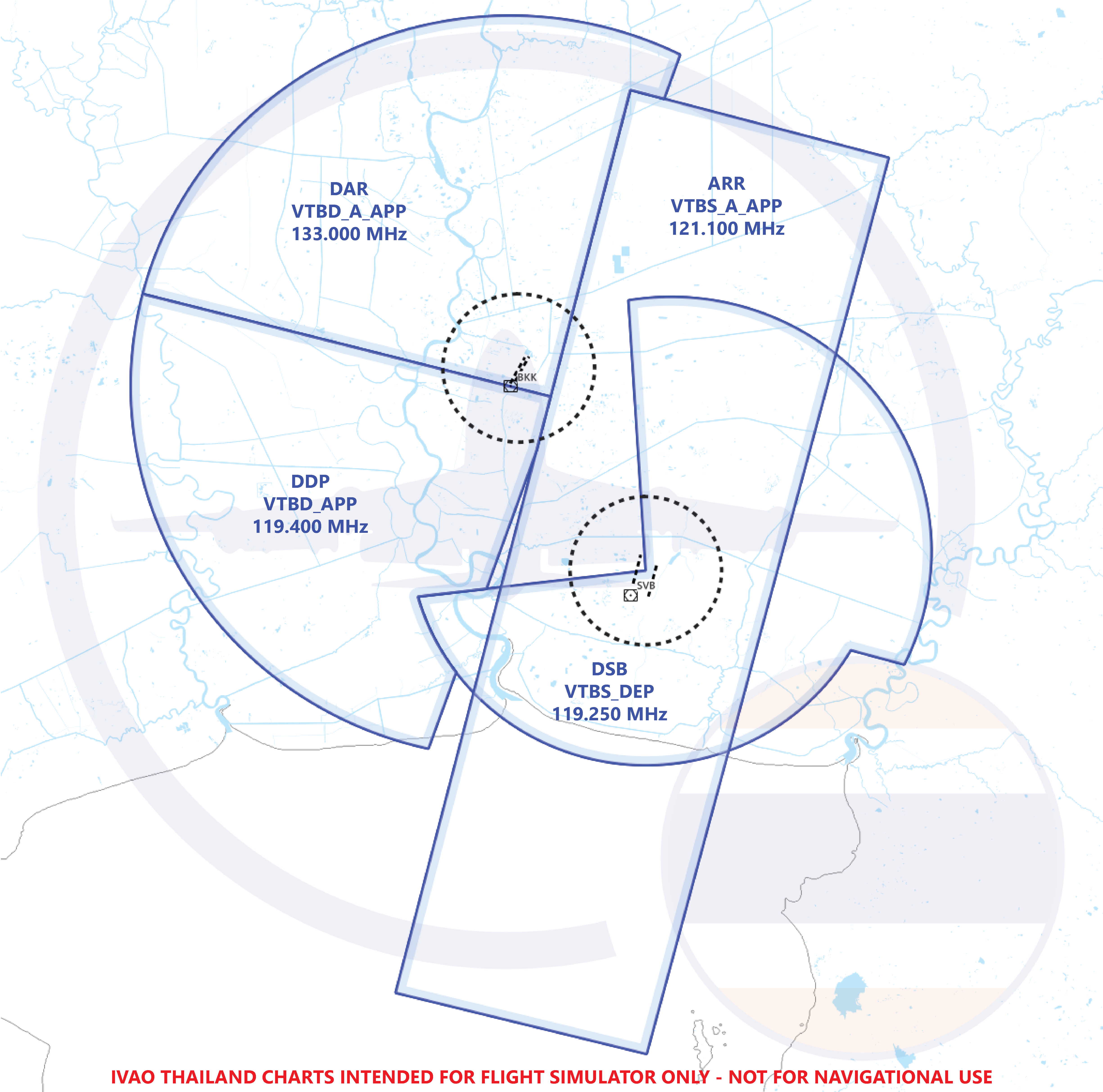
| VTBD_APP | Don Mueang Approach | 119.400 MHz | Departure Aircraft from Don Mueang until 8,000 ft |
| VTBD_A_APP | Don Mueang Arrival | 133.000 MHz | Arrival Aircraft to Don Mueang below 9,000 ft |
| VTBB_N_APP | Bangkok Approach | 133.400 MHz | - |
| VTBB_NE_APP | Bangkok Approach | 119.100 MHz | - |
| VTBB_SE_APP | Bangkok Approach | 122.350 MHz | - |
| VTBB_S_APP | Bangkok Approach | 122.300 MHz | - |
| VTBB_SW_APP | Bangkok Approach | 124.350 MHz | - |
| VTBB_W_APP | Bangkok Approach | 125.200 MHz | - |
Bangkok Approach (VTBB_APP) controls Don Mueang Aerodrome and Suvarnabhumi Aerodrome BUT Don Mueang Approach (VTBD_APP) controls ONLY Don Mueang Aerodrome
¶ 3.3. CONTROLLER CONTROL AREA CHART
¶ 3.3.1. Don Mueang Ground / Tower Chart
¶ 3.3.2. Don Mueang Approach
Don Mueang Approach Sectorisation
Don Mueang Sectorisation
(VTBS_A_APP & VTBS_DEP Online)
¶ 3.3.3. Bangkok Approach
Bangkok Approach Sectorisation
¶ 4. RADIO NAVIGATION AND LANDING AIDS
| Type of NAVAID | ID | Frequency | Coordinate |
|---|---|---|---|
| DVOR / DME | BKK | 117.700 MHz CH 124X |
135336.8N 1003546.3E |
| ILS CAT I LOC RWY 03L | I-BKD | 109.700 MHz | 134222.3N 1004437.8E |
| DME (RWY 03L) | I-BKD | CH34X | 135544.88N 1003647.53E |
| GP (RWY 03L) | I-BKD | 333.200 MHz | 135356.48N 1003554.02E |
| ILS CAT I LOC RWY 21L | I-DMG | 110.300 MHz | 135351.83N 1003601.85E |
| GP / DME (RWY 21L) | I-DMG | 335.000 MHz CH 40X |
135521.25N 1003647.45E |
| ILS CAT II LOC RWY 21R | I-BKK | 109.300 MHz | 135340.6N 1003540.6E |
| GP / DME (RWY 21R) | I-SEN | 332.000 MHz CH 30X |
135523.5N 1003642.8E |
¶ 5. ATC POSITION PROCEDURE
Controllers are required to complete the ATIS information and tune to the correct frequency before connecting to the server.
-
In the event that there are no further upper ATC facilities available, controllers shall instruct pilots to switch to UNICOM on the frequency 122.800 MHz.
-
This procedure is applicable to the Main ATS Communication Facilities. However, in the event that Don Mueang Airport receives Full ATS Communication Facilities, the controller must ensure to verify the next controller's frequency accurately before transferring instructions to the pilot.
¶ 5.1. Don Mueang Delivery
- After a Pilot has requested ATC Clearance to destination, Controller shall check, if following information in flight plan are filled correctly:
a. Flight rules
b. Equipment
c. SID and Route
d. Requested Flight Level
e. Destination Aerodrome
f. EET and Endurance - Controller shall give appropriate ATC clearance with following information:
a. Callsign
b. Destination Aerodrome
c. Flight Level
d. SID and Route
e. Initial Climb (Runway 21 - 8,000 ft / Runway 03 - 6,000 ft)
f. Transponder Code
g. NOTAMs (If Required) - Controller shall transfer Pilot to Don Mueang Ground frequency on 121.900 MHz. for further instruction.
NOTAMs: NOtice To AirMens.
SIDs: Standard Instrument Departures.
STARs: STandard Arrival Routes.
Delivery Phraseology Example:
- AIQ3021 ✈️ : Don Mueang Delivery, AIQ3021, Sawasdee krub.
- VTBD_DEL📡 : AIQ3021, Don Mueang Delivery, Sawasdee krub.
- AIQ3021 ✈️ : AIQ3021 stand 33, information B recieved, request ATC clearance to Phuket, FL340.
- VTBD_DEL📡 : AIQ3021, information B is correct, standby for ATC clearance.
- VTBD_DEL📡 : (Check Flight Plan)
- VTBD_DEL📡 : AIQ3021, report when ready to copy ATC clearance.
- AIQ3021 ✈️ : Ready to copy, AIQ3021
- VTBD_DEL📡 : AIQ3021, FL340 on request, cleared to Phuket via SABIS3A departure, Y8, flight plan route, climb 8,000 ft, squawk 4201.
- AIQ3021 ✈️ : Cleared AIQ3021 to Phuket via SABIS3A departure, Y8, flight plan route, climb 8,000 ft, squawk 4201, AIQ3021.
- VTBD_DEL📡 : AIQ3021, read back is correct, contact Ground 121.900 for push back and start up, Sawasdee krub.
- AIQ3021 ✈️ : 121.900, AIQ3021, Sawasdee krub.
¶ 5.2. Don Mueang Ground
- If the aircraft is departing:
a. When a Pilot is ready for push back and start up Controller shall give the clearance with the Facing (North, South, East, West depends on parking stand) to the Pilot. In case of requesting aircraft is located at Civil Terminal (Terminal 1 and Terminal 2), push back into taxiway B shall be given.
b. After Pilot ready to taxi Controller shall give the following information/clearance to the pilot:
i. QNH
ii. Taxi route depends on runways in use and NOTAMs.
c. Transfer Pilot to Tower frequency on 118.100 MHz - If the aircraft just arrived:
a. Controller shall Issue taxi clearance to Gate, If Pilot doesn’t request any specific Gate Controller could select the random Gate for the aircraft
b. After Parking completed Controller shall release Pilot to switch to UNICOM on 122.800 MHz
The ground controller has the capability to refer to the aerodrome chart to identify and provide the appropriate taxi route for aircraft movements on the ground.
Ground Phraseology Example:
[Departure]
- AIQ3021 ✈️ : Don Mueang Ground, AIQ3021, Sawasdee krub, stand 33, request push back and start up.
- VTBD_GND📡 : AIQ3021, Don Mueang Ground, Sawasdee krub, push back and start up approved facing north on B, QNH1012.
- AIQ3021 ✈️ : Push back and start up approved facing north on B, AIQ3021, QNH1012.
- AIQ3021 ✈️ : (Push back and start up complete)
- AIQ3021 ✈️ : AIQ3021, request taxi.
- VTBD_GND📡 : AIQ3021, taxi to holding point runway 21R via taxiway H, C and D.
- AIQ3021 ✈️ : Taxi to holding point runway 21R via H, C and D, AIQ3021.
- AIQ3021 ✈️ : (Passing taxiway E)
- VTBD_GND📡 : AIQ3021, contact Tower, 118.100, Sawasdee krub.
- AIQ3021 ✈️ : 118.100, AIQ3021, Sawasdee krub.
[Arrival]
- AIQ3022 ✈️ : Don Mueang Ground, AIQ3022, Sawasdee krub.
- VTBD_GND📡 : AIQ3022, Don Mueang Ground, Sawasdee krub, taxi to stand 33 via taxiway C and H.
- AIQ3022 ✈️ : Taxi to stand 33 via taxiway C and H, AIQ3022.
Real life always pushback face North or South on Taxiway B for pier 2-6. Some pilot in IVAO may not able to pushback like this.
¶ 5.3. Don Mueang Tower
The controller must ensure that the runway is not occupied by any aircraft or vehicles before issuing any clearance.
Controller would give take-off/landing clearance with the following information:
a. Wind direction and speed
b. Approach frequency
c. Any NOTAMs (if required)
d. Runway that cleared for take-off / to land
In case of runway is occupied and another aircraft is on short final approach. Controller may tell the pilot to do go around procedure.
Tower Phraseology Example:
[Departure]
- AIQ3021 ✈️ : Don Mueang Tower, AIQ3021, Sawasdee krub.
- VTBD_TWR📡 : AIQ3021, Don Mueang Tower, Sawasdee krub, after departure contact Don Mueang Approach 119.400, wind 090 degrees, 4 knots, runway 21R cleared for take-off.
- AIQ3021 ✈️ : After departure contact 119.400, runway 21R cleared for takeoff, AIQ3021, Sawasdee krub.
[In case of another traffic on final approach]
- AIQ3021 ✈️ : Don Mueang Tower, AIQ3021, Sawasdee krub.
- VTBD_TWR📡 : AIQ3021, Don Mueang Tower, Sawasdee krub, behind landing traffic B737 on short final, line up and wait runway 21R behind.
- AIQ3021 ✈️ : Behind landing traffic B737 on short final, line up and wait runway 21R behind, AIQ3021.
- VTBD_TWR📡 : (When landing traffic vacated runway)
- VTBD_TWR📡 : AIQ3021, wind 090 degrees, 4 knots, runway 21R cleared for take-off.
- AIQ3021 ✈️ : Runway 21R ckeared for takeoff, AIQ3021.
- VTBD_TWR📡 : (When AIQ3021 airborne and clear of local traffic)
- VTBD_TWR📡 : AIQ3021, contact Don Mueang Approach 119.400, Sawasdee krub.
- AIQ3021 ✈️ : 119.400, Sawasdee krub. AIQ3021.
[Arrival]
- AIQ3022 ✈️ : Don Mueang Tower, AIQ3022, Sawasdee krub, ILS Z runway 21R.
- VTBD_TWR📡 : AIQ3022, Don Mueang Tower, Sawasdee krub, wind 090 degrees, 4 knots, runway 21R, cleared to land.
- AIQ3022 ✈️ : Runway 21R, cleared to land, AIQ3022.
- AIQ3022 ✈️ : (Landed)
- VTBD_TWR📡 : AIQ3022, vacate right O, M, C.
- AIQ3022 ✈️ : Vacate right O, M, C, AIQ3022.
- AIQ3022 ✈️ : (Runway Vacated)
- VTBD_TWR📡 : AIQ3022, contact Ground 121.900, Sawasdee krub.
- AIQ3022 ✈️ : Contact Ground 121.900, AIQ3022, Sawasdee krub.
[In case of another traffic on final approach]
- AIQ3022 ✈️ : Don Mueang Tower, AIQ3022, Sawasdee krub, ILS Z runway 21R.
- VTBD_TWR📡 : AIQ3022, Don Mueang Tower, Sawasdee krub, continue approach runway 21R.
- AIQ3022 ✈️ : Continue approach runway 21R, AIQ3022.
- VTBD_TWR📡 : AIQ3022, wind 090 degrees, 4 knots, runway 21R, cleared to land.
- AIQ3022 ✈️ : Runway 21R, cleared to land, AIQ3022.
- AIQ3022 ✈️ : (Landed)
- VTBD_TWR📡 : AIQ3022, vacate right O, M, C.
- AIQ3022 ✈️ : Vacate right O, M, C, AIQ3022.
- AIQ3022 ✈️ : (Runway Vacated)
- VTBD_TWR📡 : AIQ3022, contact Ground 121.900, Sawasdee krub.
- AIQ3022 ✈️ : Contact Ground 121.900, AIQ3022, Sawasdee krub.
¶ 5.4. Don Mueang Approach
At this ATC position Controller will get most traffic volume in Don Mueang aerodrome. Controller need to think carefully before issue any clearance.
- If the aircraft just taken off:
a. Controller may issue clearance to climb via SID to 8,000 ft.
b. If there is Bangkok Control online, approach may coordinate with Bangkok Control for departing aircraft to climb FL260 within your 50 nm TMA before transfer to Bangkok Control. This procedure is being made to improve traffic flow in Bangkok TMA.
c. After aircraft is passing or approaching FL160 Controller shall transfer Pilot to Bangkok Control frequency on 128.100 MHz If available.
d. If there is Bangkok Approach online as VTBB_APP, the upper limit of VTBD_APP will be reduced to 8,000 ft. for departure traffic and will receive traffic from VTBB_APP at 9,000 ft.
e. Do not clear aircraft above 8,000 ft for SIDs that contain the waypoint INTOS when there is arriving traffic to pass DUGIX at 9,000 ft. - If the aircraft is arriving:
a. Controller may issue clearance to descend via STARs to appropriate altitude with following information:
i. Type of Approach (ILS/RNAV/VOR/DME/VISUAL)
ii. Runway for arrival
iii. QNH
iv. Transponder Code (If the pilot hasn’t received one)
b. When Pilot is approaching Intermediate Fix Controller shall clear “Type of approach” to the Pilot.
c. As soon as Pilot is over Intermediate Fix or Establish Localizer, Controller shall transfer Pilot to Tower frequency on 118.100 MHz.
Approach Phraseology Example:
[Departure]
- AIQ3021 ✈️ : Don Mueang Approach, AIQ3021, Sawasdee krub, passing 2,000 ft for 8,000 ft, SABIS3A departure.
- VTBD_APP📡 : AIQ3021, Don Mueang Approach, Sawasdee krub, radar contact, climb via SID to 8,000 ft, report passing 6,000 ft.
- AIQ3021 ✈️ : Climb via SID to 8,000 ft, report passing 6,000 ft, AIQ3021.
- AIQ3021 ✈️ : (Passing 6,000ft)
- AIQ3021 ✈️ : Passing 6,000 ft, AIQ3021.
- VTBD_APP📡 : AIQ3021, Contact Bangkok Approach on 125.200, Sawasdee krub.
- AIQ3021 ✈️ : 125.200, AIQ3021, Sawasdee krub.
[Arrival aircraft on SABAI3A Arrival]
- AIQ3022 ✈️ : Don Mueang Approach, AIQ3022, Sawasdee krub, information B receive, descend passing FL190 for FL170, SABAI3A arrival.
- VTBD_APP📡 : AIQ3022, Don Mueang Approach, Sawasdee krub, descend via STAR to 9,000 ft, QNH1012. Expect ILS Z runway 21R.
- AIQ3022 ✈️ : Descend via STAR to 9,000 ft, QNH1012. Expect ILS Z runway 21R , AIQ3022.
- AIQ3022 ✈️ : (Passing DUGIX)
- VTBD_APP📡 : AIQ3022, Descend and maintain 2,600 ft, clear ILS Z runway 21R, report establish localizer.
- AIQ3022 ✈️ : Descend to 2,600 ft, clear ILS Z runway 21R, report establish localizer, AIQ3022.
- AIQ3022 ✈️ : (Establish Localizer)
- AIQ3022 ✈️ : Establish localizer runway 21R, AIQ3022.
- VTBD_APP📡 : AIQ3022, Contact Don Mueang Tower on 118.100, Sawasdee krub.
- AIQ3022 ✈️ : 118.100, AIQ3022, Sawasdee krub.
¶ 6. FLIGHT PROCEDURE
¶ 6.1. Standard Instrument Departure (SID)
| RNAV SIDs | ||||
|---|---|---|---|---|
| Outbound Routes | Runway 21R | Runway 03L | Runway 21L | Runway 03R |
| A1 | ROBKA 3A | ROBKA 1B | ROBKA 3C | ROBKA 1D |
| A464 (North) | SEMBO 3A | SEMBO 1B | SEMBO 3C | SEMBO 1D |
| A464 (South), M751, W19 | REGOS 3A | REGOS 1B | REGOS 3C | REGOS 1D |
| B346, W21 | NOBER 3A | NOBER 1B | NOBER 3C | NOBER 1D |
| G458 | UKERA 3A | UKERA 1B | UKERA 3C | UKERA 1D |
| G463, P646 | TARED 3A | TARED 1B | TARED 3C | TARED 1D |
| G474, L880 | DOSBU 3A | DOSBU 1B | DOSBU 3C | DOSBU 1D |
| L301 | PASTO 3A | PASTO 1B | PASTO 3C | PASTO 1D |
| L507 | NUNLI 3A | NUNLI 1B | NUNLI 3C | NUNLI 1D |
| M502 | BONVO 3A | BONVO 1B | BONVO 3C | BONVO 1D |
| M757 | KASNI 3A | KASNI 1B | KASNI 3C | KASNI 1D |
| M904, R201, Y11 | KIGOB 3A | KIGOB 1B | KIGOB 3C | KIGOB 1D |
| N506, R468 | GORSI 3A | GORSI 1B | GORSI 3C | GORSI 1D |
| N891 | RYN 3A | RYN 1B | RYN 3C | RYN 1D |
| R474 | ALBOS 3A | ALBOS 1B | ALBOS 3C | ALBOS 1D |
| W9 | TL 3A | TL 1B | TL 3C | TL 1D |
| W31 | HHN 3A | HHN 1B | HHN 3C | HHN 1D |
| Y6 | TANGO 3A | TANGO 1B | TANGO 3C | TANGO 1D |
| Y8 | SABIS 3A | SABIS 2B | SABIS 3C | SABIS 2D |
| Y16 | UPKUP 3A | UPKUP 1B | UPKUP 3C | UPKUP 1D |
¶ 6.2. Standard Terminal Arrival Route (STAR)
| RNAV STARs | |||
|---|---|---|---|
| Inbound Routes | Transitions | Runway 21L/R | Runway 03L/R |
| W1, Y1, Y2, Y20 | UBLOD | ENDUU 3A | ENDUU 1B |
| A464 (North) | SEMBO | NAKON 3A | NAKON 1B |
| B346, W21 | NOBER | NAKON 3A | NAKON 1B |
| R474 | ALBOS | NAKON 3A | NAKON 1B |
| W9, Y7 | TL | NAKON 3A | NAKON 1B |
| A464 (South), M751, W19 | GUTSO | SABAI 3A | SABAI 1B |
| G458, W31, Y99 | HOTEL | SABAI 3A | SABAI 1B |
| M769, W42, Y5, Y98 | SURMA | SABAI 3A | SABAI 1B |
| M904, R201, Y11 | BUT | SABAI 3A | SABAI 1B |
| G474, L880 | ANREN | SEHNA 3A | SEHNA 1B |
| M633 | DULEM | SEHNA 3A | SEHNA 1B |
| N506, R468 | GOMES | SEHNA 3A | SEHNA 1B |
| N891 | RYN | SEHNA 3A | SEHNA 1B |
| P629 | NUGPA | SEHNA 3A | SEHNA 1B |
| Y12 | ALEMI | SEHNA 3A | SEHNA 1B |
| G463, P646 | TARED | WEHHA 3A | WEHHA 1B |
| L301 | PASTO | WEHHA 3A | WEHHA 1B |
| L507 | IGONI | WEHHA 3A | WEHHA 1B |
| L524 | IBETO | WEHHA 3A | WEHHA 1B |
| M502 | BONVO | WEHHA 3A | WEHHA 1B |
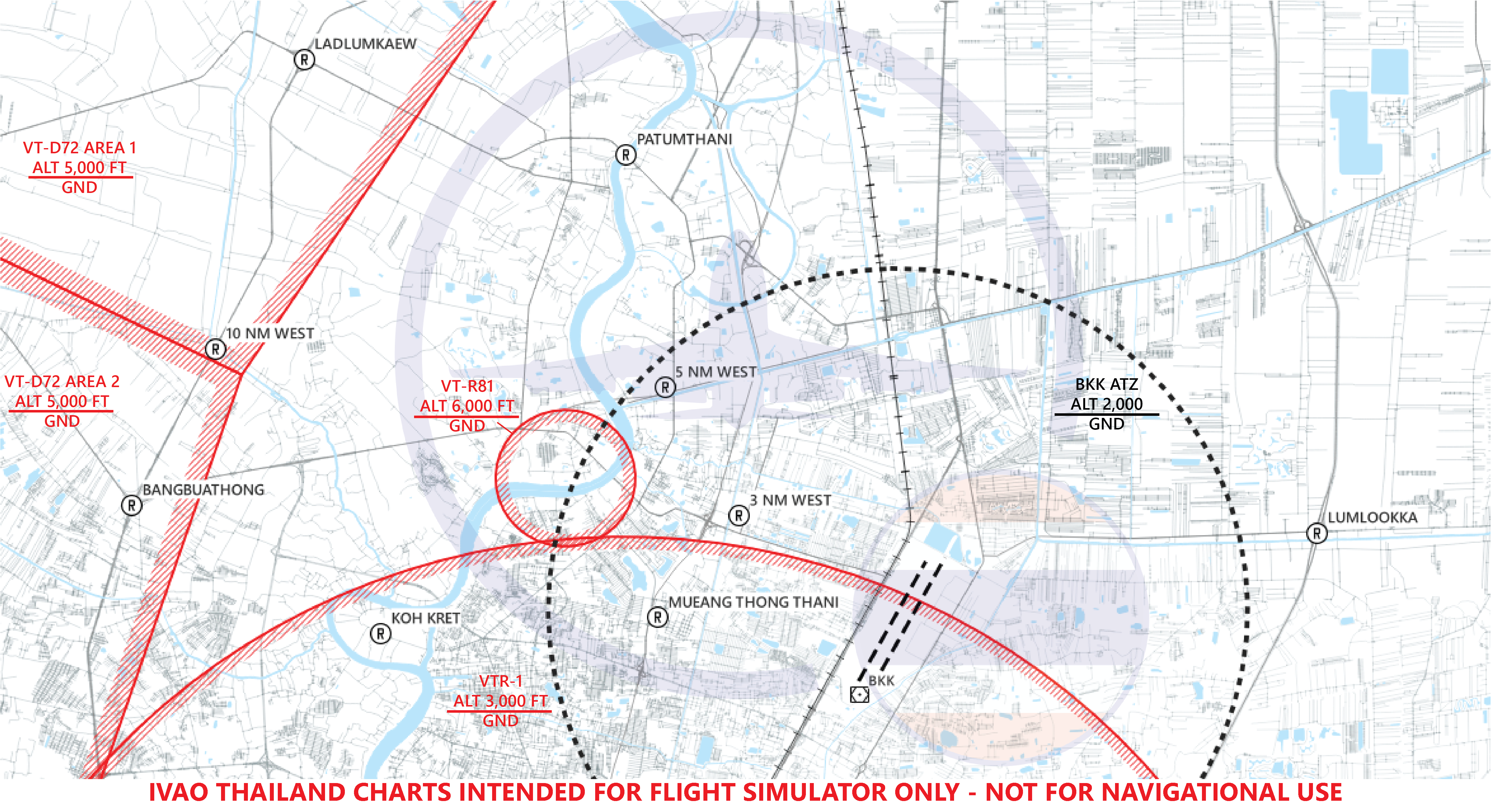
¶ 6.3. VFR Procedure for Light Aircraft
¶ Reporting Point
| Reporting Point | Pronounciation | Landmark | Radial/DME from BKK VOR | Lat/Long |
|---|---|---|---|---|
| 3 NM WEST | 3 - MILE - WEST | Armed Forces Development Command (Dome shape) | R317/3.14D | 135556N 1003295E |
| 5 NM WEST | 5 - MILE - WEST | Government Housing Complex Tiwanon (Ban Uea Athon Tiwanon) | R331/5.5D | 135815N 1003254E |
| 10 NM WEST | 10 - MILE - WEST | Bangkok Western Outer Ring Rd. crossing Pra-u-dom canal | R298/10.5D | 135843N 1002618E |
| AYUTTHAYA | A - YUT - THA - YA | Preedee Panomyong Bridge (Ayutthaya Downtown) | R356/28.32D | 142200N 1003400E |
| BANGBUATHONG | BANG - BUA - THONG | Bangkok Western Outer Ring Rd. crossing the Highway 345 (Bang Bua Thong Interchange) | R284/10.15D | 135610N 1002540E |
| BANGLOOKSUA | BANG - LOOK - SUA | Pradhana Vanalai Studio | R070/29.0D | 140310N 1010404E |
| BANG NAM PREAW | BANG - NAM - PRIAO | Bang Nam Priao District Office | R097/26.4D | 135014N 1010210E |
| BANGPAKONG | BANG - PA - KONG | Bang Pa Kong River Delta | R137/34.3D | 132809N 1005945E |
| HINKONG | HIN - KONG | Racetrack Ring Highway Interchange (Hin Kong Interchange) | R028/34.86D | 142430N 1005240E |
| KOH LAN | KOH - LAN | Koh Lan Island | R169/59D | 125453N 1004649E |
| KOHSRICHANG | KOH - SI - CHANG | Koh Sichang Island | R167/45.00D | 130745N 1004840E |
| LADBUALUANG | LAD - BUA - LUANG | Lat Bua Luang District Office | R314/23.5D | 140957N 1001814E |
| LADLUMKAEW | LAD - LUM - KAEW | Bangkok Western Outer Ring Rd. crossing the Highway 346 | R319/12D | 140245N 1002746E |
| LUMLOOKKA | LUM - LOOK - KA | Bangkok Eastern Outer Ring Rd. crossing Lumlookka Rd. (Lam Luk Ka Interchange) | R070/7.42D | 135609N 1004257E |
| KOH KRET | KOH - KRET | Koh Kret Island | R289/6D | 135529N 1002953E |
| MUEANG THONG THANI | MUEANG - THONG - THA - NI | IMPACT Exhibition Center | R239/6.9D | 134958N 1002943E |
| PATUMTHANI | PA - TUM - THA - NI | Patumthani Bridge 1 (Crossing Chaopraya River) (Not to be confused with Patumthani Bridge 2) | R341/8.74D | 140156N 1003255E |
| SAMUTSAKORN | SA - MUT - SA - KORN | Tha Chin River Delta (Not to be mistaken with Mae Klong River Delta) | R221/27.48D | 133300N 1001700E |
VFR reporting point near Don Mueang International Airport.
VFR reporting point inside Bangkok TMA.
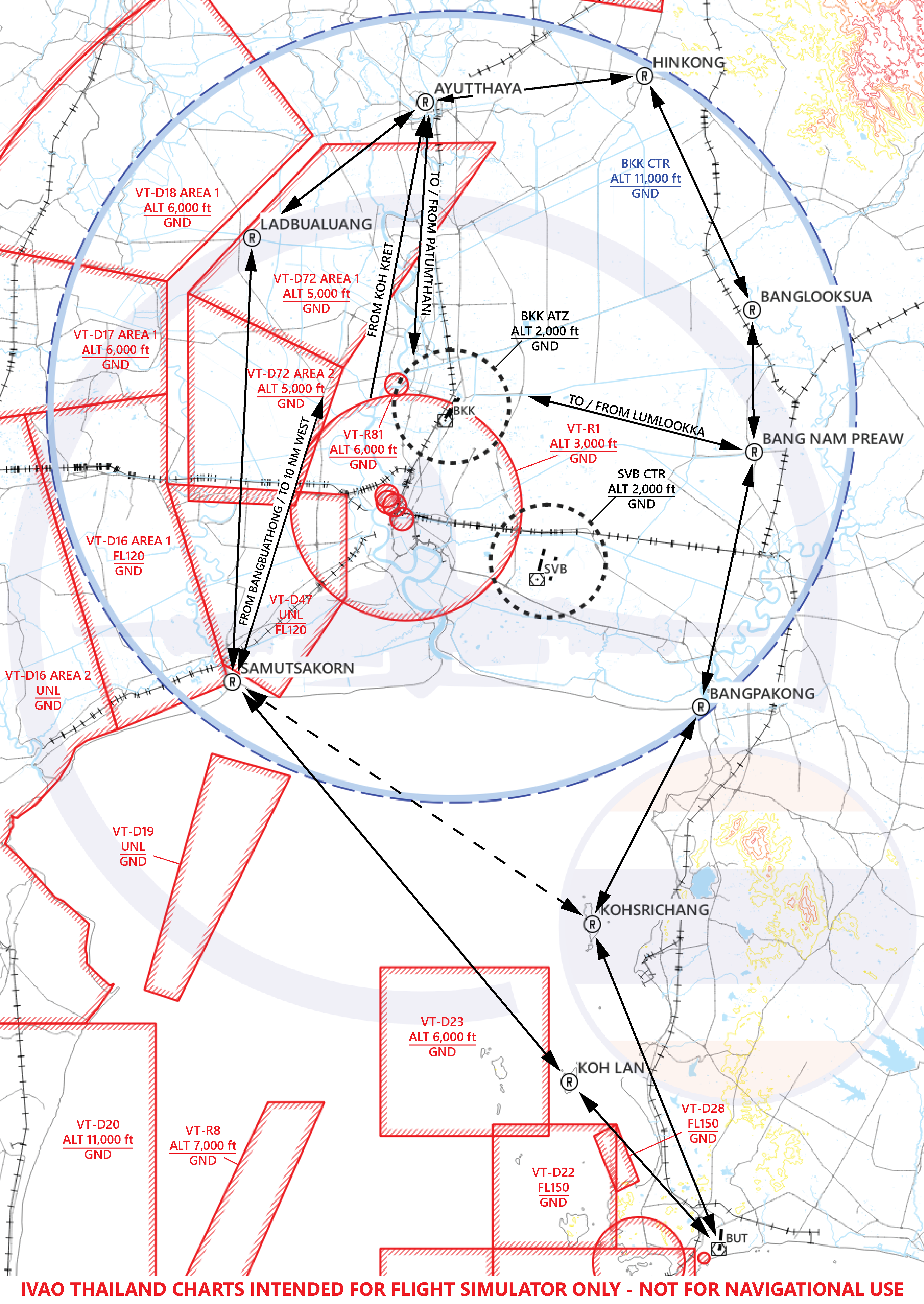
¶ Entry Procedure
| Entry Point | Reporting Point for Entry / Altitude | |||
|---|---|---|---|---|
| AYUTTHAYA (North) BELOW 2,000 ft |
PATUMTHANI BELOW 1,000 ft |
5 NM WEST BELOW 1,000 ft |
3 NM WEST BELOW 1,000 ft |
- |
| HINKONG (Northeast) ABOVE 4,500 ft |
AYUTTHAYA BELOW 2,000 ft |
PATUMTHANI BELOW 1,000 ft |
5 NM WEST BELOW 1,000 ft |
3 NM WEST BELOW 1,000 ft |
| BANGLOOKSUA (East) BELOW 1,500 ft |
BANG NAM PREAW BELOW 1,000 ft |
LUMLOOKKA BELOW 1,000 ft |
- | - |
| BANG NAM PREAW (East) BELOW 1,000 ft |
LUMLOOKKA BELOW 1,000 ft |
- | - | - |
| BANGPAKONG (Southeast) BELOW 1,500 ft |
BANG NAM PREAW BELOW 1,000 ft |
LUMLOOKKA BELOW 1,000 ft |
- | - |
| KOH LAN (Southeast) BELOW 2,000 ft |
SAMUTSAKORN BELOW 2,000 ft |
10 NM WEST 1,500 ft |
5 NM WEST BELOW 1,000 ft |
3 NM WEST BELOW 1,000 ft |
| KOHSRICHANG(*) (Southeast) 2,000 ft |
SAMUTSAKORN BELOW 2,000 ft |
10 NM WEST 1,500 ft |
5 NM WEST BELOW 1,000 ft |
3 NM WEST BELOW 1,000 ft |
| SAMUTSAKORN (Southwest) BELOW 2,000 ft |
10 NM WEST 1,500 ft |
5 NM WEST BELOW 1,000 ft |
3 NM WEST BELOW 1,000 ft |
- |
| LADBUALUANG (West) | LADLUMKAEW BELOW 1,000 ft |
PATUMTHANI BELOW 1,000 ft |
5 NM WEST BELOW 1,000 ft |
3 NM WEST BELOW 1,000 ft |
Note: (*) When VTD 22 or VTD 23 active, U-TAPAO Approach will assign the aircraft to report over KOH SRICHANG reporting point.
At 5 NM WEST / LUMLOOKKA arriving aircraft will be instructed to contact Don Mueang Tower on 118.100.
After 3 NM WEST / LUMLOOKKA arriving aircraft will be instructed to join circuit pattern for runway 03/21.
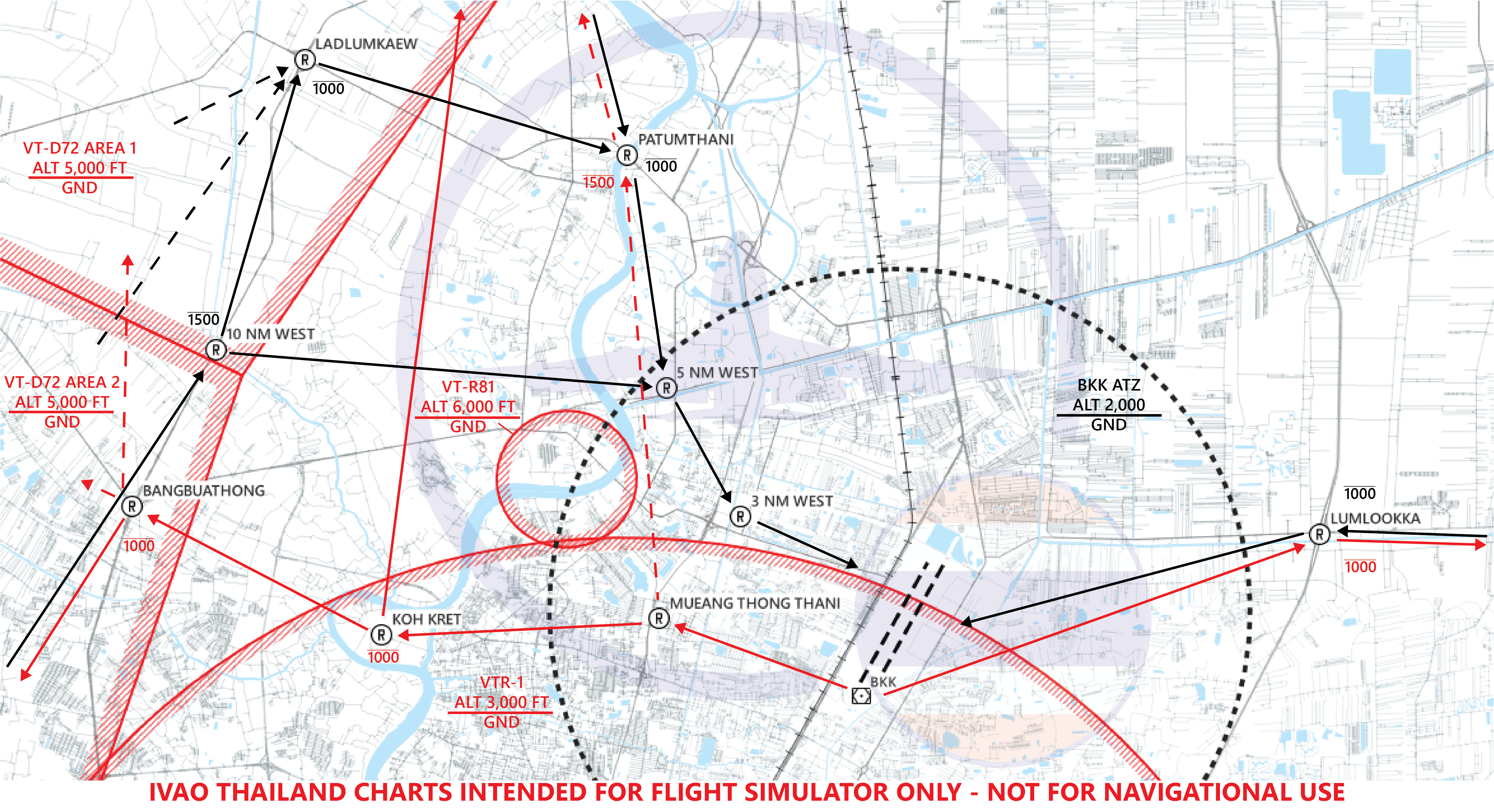
¶ Exit Procedure
¶ Runway 21L/R
| Direction of Flight | Reporting Point for Exit / Altitude | ||||
|---|---|---|---|---|---|
| North | MUEANG THONG THANI | KOH KRET BELOW 1,000 ft |
AYUTTHAYA BELOW 2,500 ft |
- | - |
| North* | MUEANG THONG THANI | PATUMTHANI BELOW 1,500 ft |
AYUTTHAYA BELOW 2,500 ft |
- | - |
| Northeast | MUEANG THONG THANI | KOH KRET BELOW 1,000 ft |
AYUTTHAYA BELOW 2,500 ft |
HINKONG BELOW 3,500 ft |
- |
| Northeast* | MUEANG THONG THANI | PATUMTHANI BELOW 1,500 ft |
AYUTTHAYA BELOW 2,500 ft |
HINKONG BELOW 3,500 ft |
- |
| East | LUMLOOKKA BELOW 1,000 ft |
BANG NAM PREAW BELOW 1,000 ft |
- | - | - |
| Southeast (1) | LUMLOOKKA BELOW 1,000 ft |
BANG NAM PREAW BELOW 1,000 ft |
BANGPAKONG BELOW 1,500 ft |
- | - |
| Southeast (2)** | MUEANG THONG THANI | KOH KRET BELOW 1,000 ft |
BANGBUATHONG BELOW 1,000 ft |
SAMUTSAKORN BELOW 2,500 ft |
KOHSRICHANG ABOVE 3,500 ft |
| Southeast (3) | MUEANG THONG THANI | KOH KRET BELOW 1,000 ft |
BANGBUATHONG BELOW 1,000 ft |
SAMUTSAKORN BELOW 2,500 ft |
KOH LAN ABOVE 2,500 ft |
| Southwest | MUEANG THONG THANI | KOH KRET BELOW 1,000 ft |
BANGBUATHONG BELOW 1,000 ft |
SAMUTSAKORN BELOW 2,500 ft |
- |
| West | MUEANG THONG THANI | KOH KRET BELOW 1,000 ft |
BANGBUATHONG BELOW 1,000 ft |
- | - |
Note: (*) Optimal route for exit, can only be use when there is no traffic inbound.
Note: (**) When VT-D22 or VT-D23 active, U-TAPAO Approach will assign the aircraft to report over KOH SRICHANG reporting point.
At MUEANG THONG THANI / LUMLOOKKA departing aircraft will be instructed to contact Approach Controller.
¶ Runway 03L/R
| Direction of Flight | Reporting Point for Exit / Altitude | |||
|---|---|---|---|---|
| North | PATUMTHANI BELOW 1,500 ft |
AYUTTHAYA BELOW 2,500 ft |
- | - |
| Northeast | PATUMTHANI BELOW 1,500 ft |
AYUTTHAYA BELOW 2,500 ft |
HINKONG BELOW 3,500 ft |
- |
| East | LUMLOOKKA BELOW 1,000 ft |
BANG NAM PREAW BELOW 1,000 ft |
- | - |
| Southeast (1) | LUMLOOKKA BELOW 1,000 ft |
BANG NAM PREAW BELOW 1,000 ft |
BANGPAKONG BELOW 1,500 ft |
- |
| Southeast (2)* | PATUMTHANI BELOW 1,500 ft |
LADLUMKAEW BELOW 1,500 ft |
SAMUTSAKORN BELOW 2,500 ft |
KOHSRICHANG ABOVE 3,500 ft |
| Southeast (3) | PATUMTHANI BELOW 1,500 ft |
LADLUMKAEW BELOW 1,500 ft |
SAMUTSAKORN BELOW 2,500 ft |
KOH LAN ABOVE 2,500 ft |
| Southwest | PATUMTHANI BELOW 1,500 ft |
LADLUMKAEW BELOW 1,500 ft |
SAMUTSAKORN BELOW 2,500 ft |
- |
| West | PATUMTHANI BELOW 1,500 ft |
LADLUMKAEW BELOW 1,500 ft |
- | - |
Note: (*) When VT-D22 or VT-D23 active, U-TAPAO Approach will assign the aircraft to report over KOH SRICHANG reporting point.
At PATUMTHANI / LUMLOOKKA departing aircraft will be instructed to contact Approach Controller.
¶ 7. LOCAL AERODROME REGULATIONS
For more information: https://aip.caat.or.th, On Part 3, AD 2 Aerodromes, VTBD
¶ 7.1. Use of Runway 03R/21L
- The use of Runway 03R/21L at Don Mueang International Airport is normally restricted to military traffic. But they may be made available to civil traffic. The hours of operation is 24 hours daily, all traffic is controlled by Don Mueang Tower.
- The traffic circuit pattern for these runways is as follows:
2.1. Outbound - after take-off, turn to east and leave circuit pattern at an angle of 45° to the cross-wind leg.
2.2. Inbound - join circuit pattern at 45° in the middle of the down - wind leg east of the runway, at the following heights:
a. 1,500 FT for jet aircraft,
b. 1,000 FT for conventional aircraft,
c. 1,000 FT for light aircraft,
d. 500 FT for helicopter.
2.3. No straight in approaches are permitted without prior approval from Don Mueang Tower.
In case of heavy traffic e.g. IVAO official events RWY 03R/21L shall be use for departure and RWY 03L/21R for arrival to increase traffic flow
¶ 7.2. Runway Operation
- If traffic on final more than 8 nm, departing traffic can line up and take off on runway 21R.
- If traffic on final is between 4 - 8 nm, departing traffic can be instructed to cross runway 21R to depart from runway 21L.
- If traffic on final is less than 4 nm, departing traffic must hold short of runway 21R to allow arriving traffic to land first.
¶ 7.3. Training in Danger Area
VT-D47
-
Jet / Conventional Aircraft departing from Don Mueang International Airport must contact Don Mueang Approach on frequency 119.4 MHZ
-
Before leaving VT-D47 the pilot must report his position, distance and heading to Don Mueang Approach.
-
Test Flights: If the pilot desires to fly outside the area of VT-D47, he must maintain two-way radio communications with, and follow instruction from Bangkok Approach/Don Mueang Approach.
VT-D72
- Light Aircraft departing form Don Mueang International Airport must contact Don Mueang Approach, the controller will instruct the pilot over Bangbuathong at altitude not above 1,000 ft before entering VT-D72.
- Before leaving VT-D72 the pilot must report his position, distance and heading to Don Mueang Approach. The controller will instruct the pilot to report over Ladlumkaew at altitude not above 1,000 ft, report Patumtani, 5 NM West and then report entering downwind for landing RWY 21L/R or RWY 03R/L.
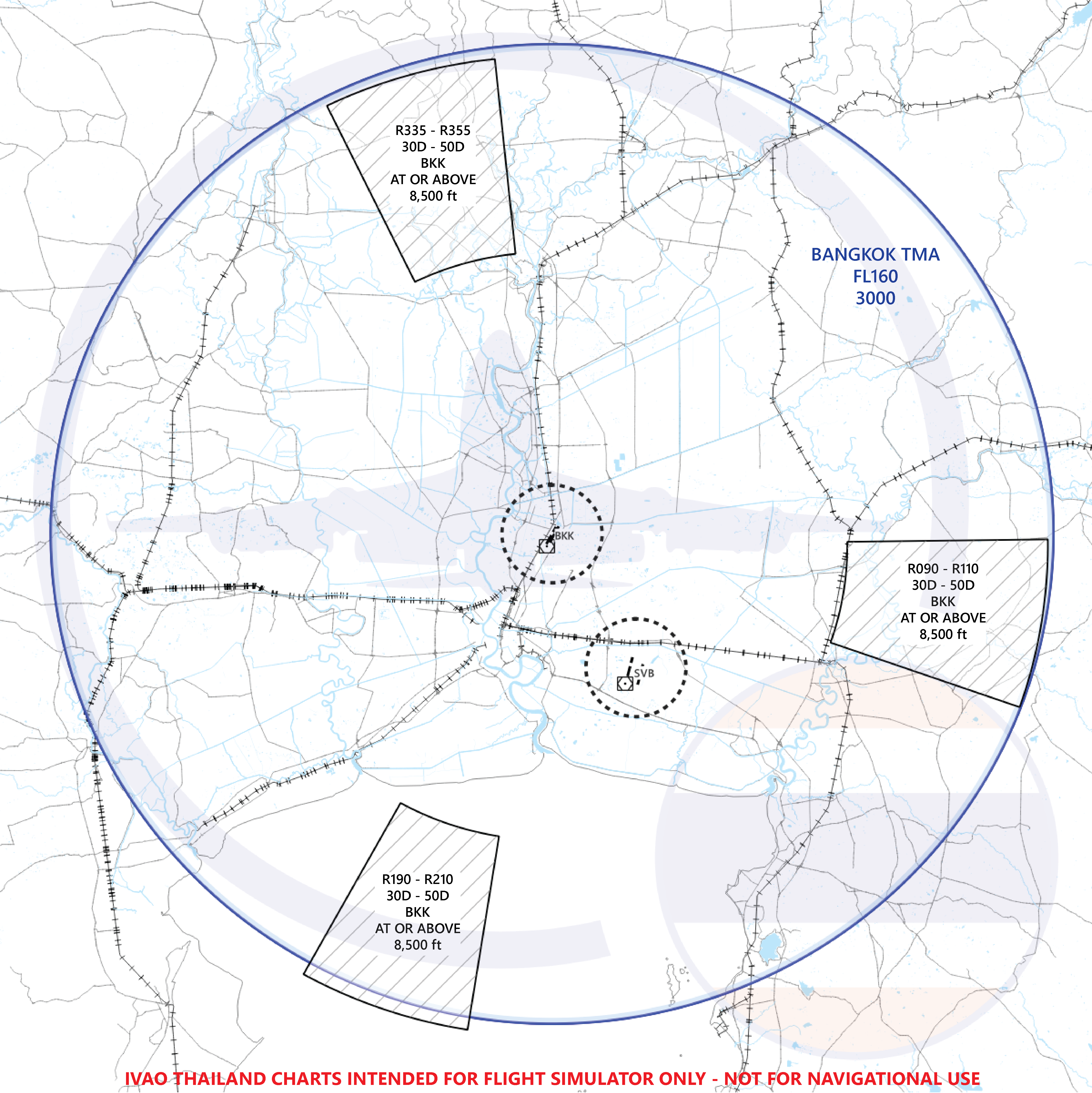
¶ 7.4. Fuel Jettison Area
Fuel jettison area has been establish in the Bangkok TMA to facilitate emergency aircraft in the following area.
- North fuel dumping area: between R-335 and R-355, distance of 30 to 50 NM from BKK VOR, altitude at or above 8,500 ft.
- East fuel dumping area: between R-090 and R-110, distance of 30 to 50 NM from BKK VOR, altitude at or above 8,500 ft.
- South fuel dumping area: between R-190 and R-210, distance of 30 to 50 NM from BKK VOR, altitude at or above 8,500 ft.
¶ 8. ADDITIONAL INFORMATION
¶ Ground Movement Control Procedure
- Departing aircraft for Runway 21R shall remain on Ground frequency 121.900 MHz until approaching taxiway E, and maintain a listening watch on Tower frequency 118.100 MHz while on Taxiway C to assist with sequencing of aircraft onto the active runway.
- Arriving aircraft shall remain on Ground frequency 121.900 MHz until entering the apron area or until a frequency change is instructed.
¶ Airbus A380 and Boeing 747-8 operations (Wingspan limitations)
- ONLY Runway 03L/21R shall be used for arrivals and departures.
- The primary parking position is stand 80 and the alternate parking positions are stand 90 and Taxiway B North.
- While the A380 and B747-8 is operating on Taxiway C. Traffic on Taxiway B shall be limited not to exceed the aircraft code C. (aircraft with a maximum wingspan of 118' or 36 meters)
¶ Special Procedures
At NAKON, WEHHA, OPERA and NODEG, pilots are expected to cross these waypoints 2 minutes after preceding. Time constraints will be issued by Bangkok Control. Pilots shall adjust their speed to meet the criteria. If pilot unable to cross these waypoints at the specified time, pilots shall advise ATC as soon as possible, and expect to hold as published on chart at these positions.
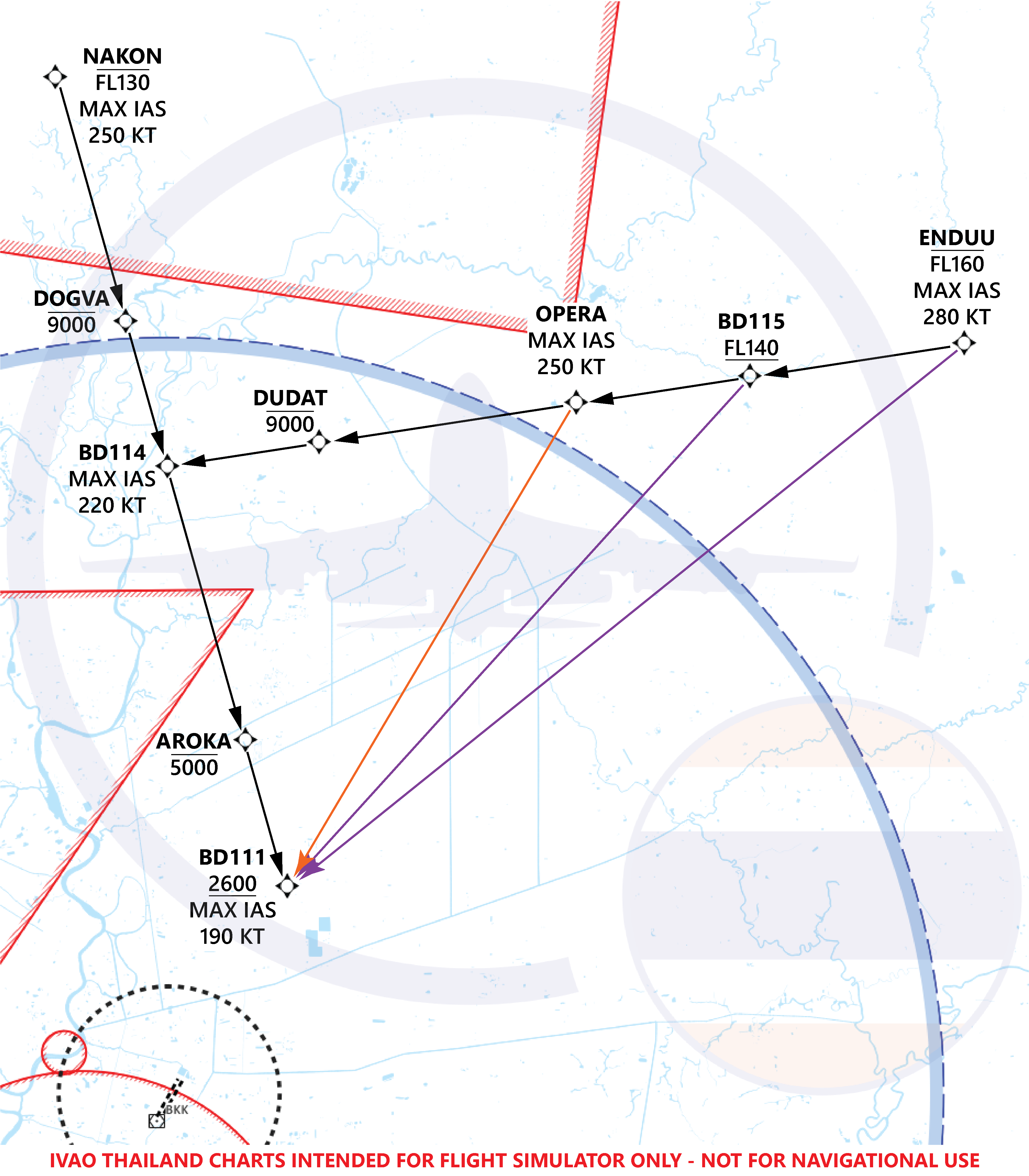
If traffic permits, the pilot can expect a shortcut after VASGO direct to NODEG or DUGIX (marked in red color). If ATC provides clearance for the shortcut, while en route to AROKA (marked in green color), the pilot should maintain a speed of 220 KIAS. When the altitude is below 4,000 ft, the pilot will receive another right turn to BD111 (marked in blue color). If traffic permits, pilot can expect a shortcut after BD112 to direct BD111 (marked in blue color).
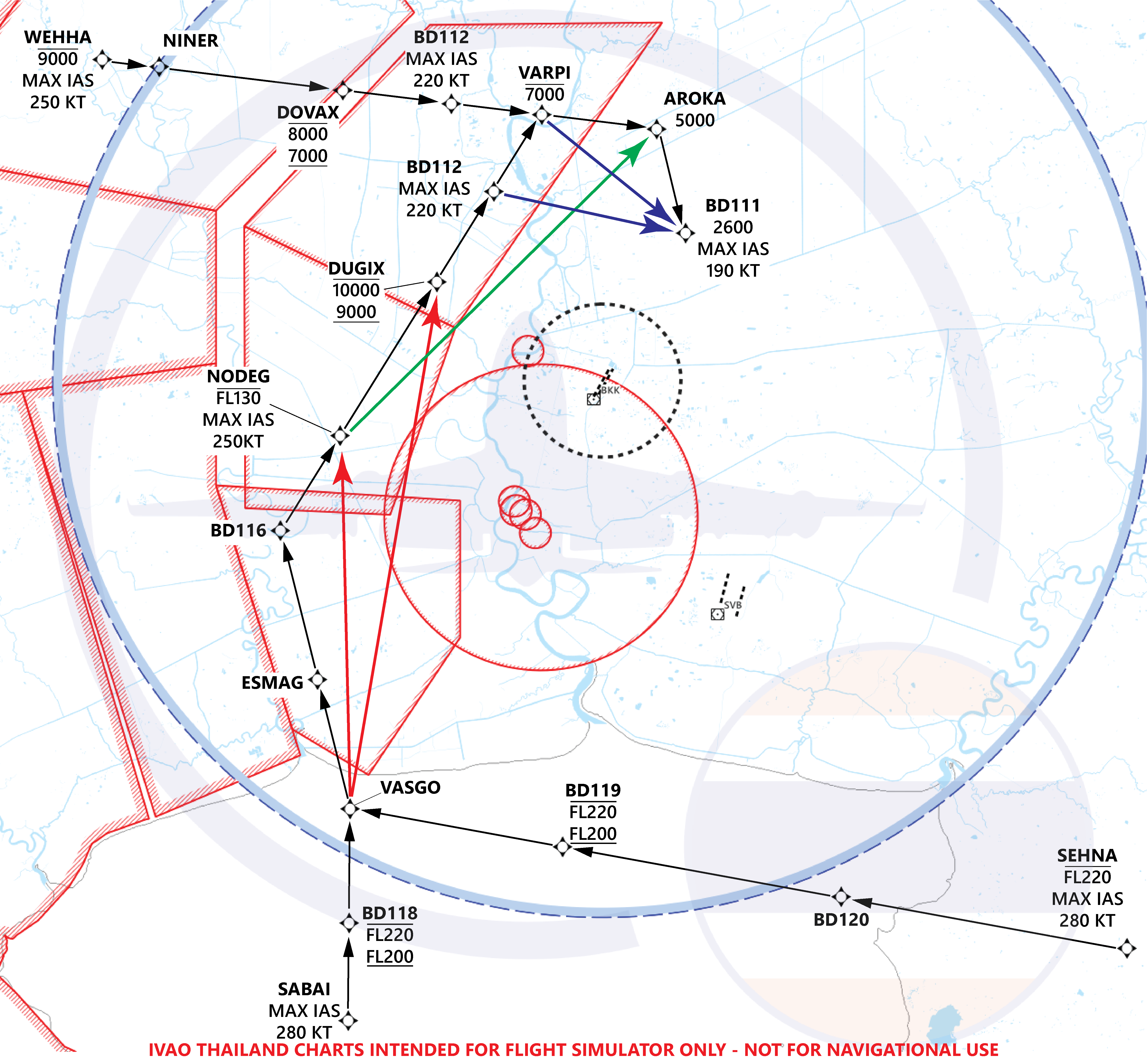
If traffic permits, the pilot can expect a shortcut after ENDUU or BD115 direct to BD111 (marked in purple color). If there is arrival traffic for VTBS, ATC will provide clearance for the shortcut from OPERA to BD111 (marked in orange color).
Warning For Taxiing Aircraft Landing on Runway 21L
Aircraft landing Runway 21L, when vacating the Runway to the right on Taxiway S, must hold short of Runway 21R at the holding point and remain on Tower frequency 118.100 MHz for permission to cross the Runway. Changing of frequency shall not be done unless advised.
¶ Reference
- ENR 2.1 FIR, UIR, TMA
- ENR 1.6 ENR 2.2 OTHER REGULATED AIRSPACE
- AD 2 Aerodromes, VTBD
¶ AUTHOR
- VID 480952 - Creation
¶ COPYRIGHT
- This documentation is copyrighted as part of the intellectual property of the International Virtual Aviation Organisation.
¶ DISCLAIMER
- The content of this documentation is intended for aviation simulation only and must not be used for real aviation operations.