¶ DON MUEANG INTERNATIONAL AIRPORT

© 357522 Chayanin Boonyawairote
¶ General
Don Mueang International Airport is one of two international airports serving the Bangkok Metropolitan Region, the other one being Suvarnabhumi Airport (BKK). Before Suvarnabhumi opened in 2006, Don Mueang was previously known as Bangkok International Airport.
¶ Airspace
¶ MAIN ATC FACILITIES
| Position | Callsign | Frequency | Minimum FRA Rating | Remarks |
|---|---|---|---|---|
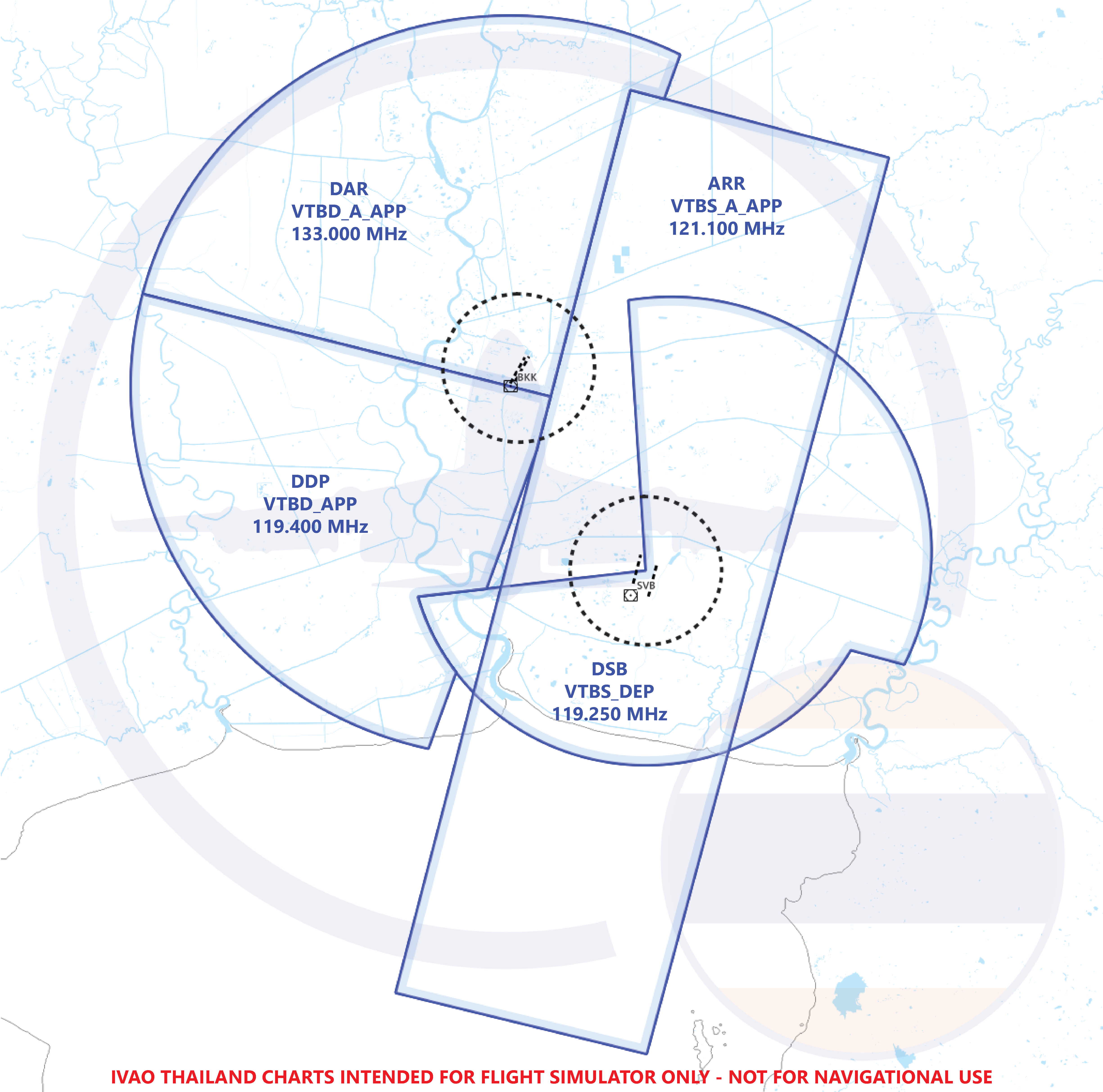
| VTBB_APP | Bangkok Approach | 125.200 MHz |  |
- |
| VTBD_APP | Don Mueang Approach | 119.400 MHz |  |
- |
| VTBD_TWR | Don Mueang Tower | 118.100 MHz |  |
- |
| VTBD_GND | Don Mueang Ground | 121.900 MHz | |
- |
| VTBD_DEL | Don Mueang Delivery | 127.700 MHz | |
- |
¶ FULL ATC FACILITIES
| Position | Callsign | Frequency | Minimum FRA Rating | Remarks |
|---|---|---|---|---|
| VTBB_APP Full ATC Facilities please see Bangkok Apporach Control | ||||
| VTBD_APP | Don Mueang Approach | 119.400 MHz | |
- |
| VTBD_A_APP | Don Mueang Approach | 133.000 MHz | |
- |
| VTBD_TWR | Don Mueang Tower | 118.100 MHz | |
- |
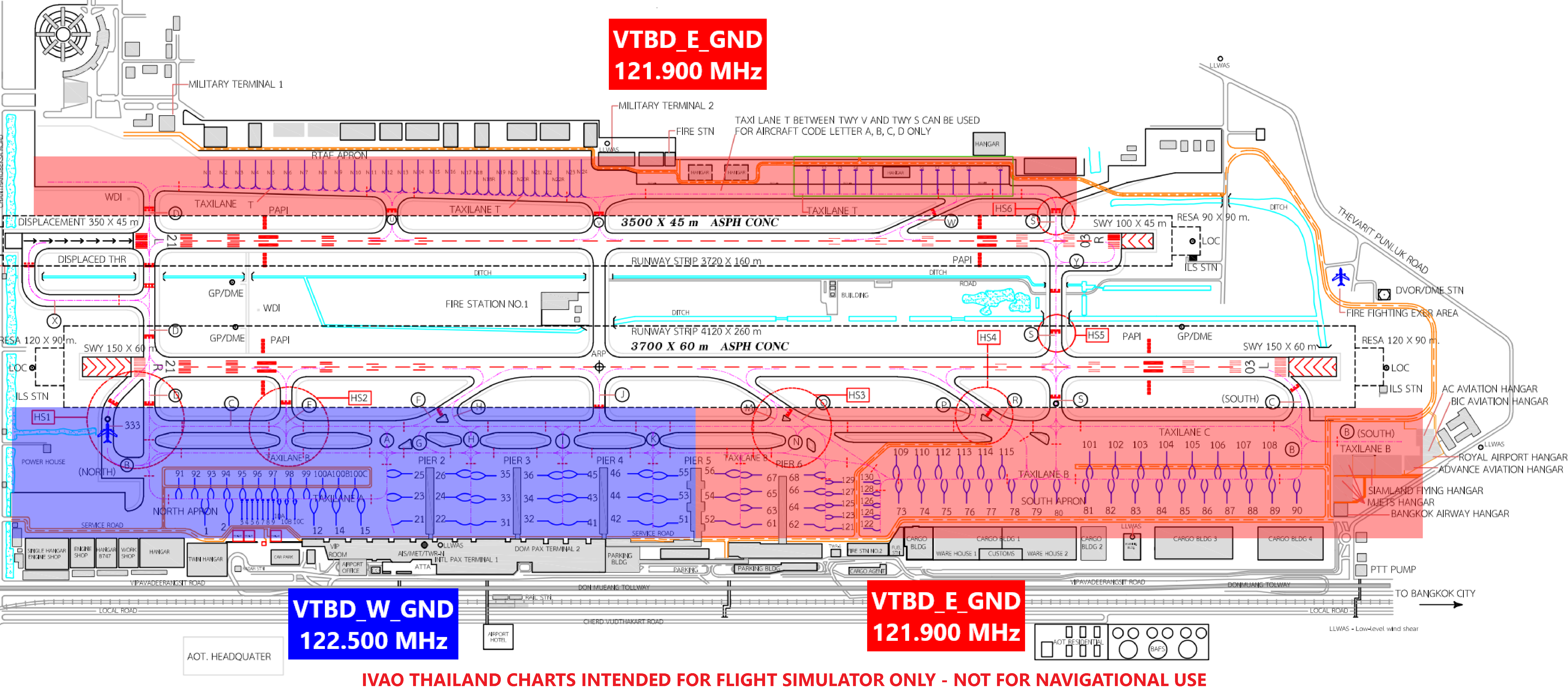
| VTBD_E_GND | Don Mueang Ground | 121.900 MHz | |
East / South Apron |
| VTBD_W_GND | Don Mueang Ground | 122.500 MHz | |
West Apron |
| VTBD_DEL | Don Mueang Delivery | 127.700 MHz | |
- |
¶ ATS AIRSPACE
| Designation and Lateral Limits | A circle of 5 NM radius centre on VTBD ARP (135452N 1003620E) |
| Vertical Limits | 2,000 ft / AGL |
| Airspace Classification | C |
| ATS Unit Callsign | Don Mueang Tower |
| Language(s) | English, Thai |
| Transition Altitude | 11,000 ft MSL |
¶ RUNWAY INFORMATION
| Runway | True Bearing | Length and Width | Surface Type | TDZ - Elevation | Lighting |
|---|---|---|---|---|---|
| 03L | 029º | 3,700 m x 60 m | Asphalt Concrete | 7 ft | SALS, Centerline, Edge |
| 03R | 028º | 3,500 m x 45 m | Asphalt | 5 ft | SALS, Edge |
| 21L | 208º | 3,500 m x 45 m | Asphalt | 6 ft | CAT I, Edge |
| 21R | 209º | 3,700 m x 60 m | Asphalt Concrete | 7 ft | CAT II, Centerline, Edge, TDZ |
SALS - Short Approach Lighting System
¶ RUNWAY DECLARED DISTANCES
| DECLARED DISTANCES (Meters) | |||||
|---|---|---|---|---|---|
| Runway | TORA | TODA | ASDA | LDA | |
| 03L | 3,700 m | 3,850 m | 3,850 m | 3,700 m | |
| 03R | 3,500 m | 3,650 m | 3,500 m | 3,500 m | |
| 21L | 3,500 m | 3,650 m | 3,600 m | 3,150 m | |
| 21R | 3,700 m | 3,850 m | 3,850 m | 3,700 m | |
TORA - Takeoff Run Available
TODA - Takeoff Distance Available
ASDA - Accelerated Distance Stop Available
LDA - Landing Distance Available
¶ RUNWAY INTERSECTION DISTANCES
Departing aircraft will normally be directed by ATC to use the full length of the runway for take-off. Pilots may request or ATC may propose an intersection departure. The final decision whether to make an intersection departure rests with the pilot.
| TAKEOFF RUN AVAILABLE (TORA) RUNWAY 03L (Meters) | |
|---|---|
| C (South) | 3,700 m |
| S | 2,960 m |
| R | 2,540 m |
| TAKEOFF RUN AVAILABLE (TORA) RUNWAY 03R (Meters) | |
|---|---|
| Y | 3,500 m |
| S | 3,350 m |
| W | 2,650 m |
| TAKEOFF RUN AVAILABLE (TORA) RUNWAY 21L (Meters) | |
|---|---|
| X | 3,500 m |
| D | 3,150 m |
| U | 2,520 m |
| TAKEOFF RUN AVAILABLE (TORA) RUNWAY 21R (Meters) | |
|---|---|
| D, B (North) | 3,700 m |
| E | 3,220 m |
| F | 2,490 m |
¶ RADIO NAVIGATION AND LANDING AIDS
| Type of NAVAID | ID | Frequency | Coordinate |
|---|---|---|---|
| DVOR / DME | BKK | 117.700 MHz CH 124X |
135336.8N 1003546.3E |
| ILS CAT I LOC RWY 03L | I-BKD | 109.700 MHz | 134222.3N 1004437.8E |
| DME (RWY 03L) | I-BKD | CH34X | 135544.88N 1003647.53E |
| GP (RWY 03L) | I-BKD | 333.200 MHz | 135356.48N 1003554.02E |
| ILS CAT I LOC RWY 21L | I-DMG | 110.300 MHz | 135351.83N 1003601.85E |
| GP / DME (RWY 21L) | I-DMG | 335.000 MHz CH 40X |
135521.25N 1003647.45E |
| ILS CAT II LOC RWY 21R | I-BKK | 109.300 MHz | 135340.6N 1003540.6E |
| GP / DME (RWY 21R) | I-SEN | 332.000 MHz CH 30X |
135523.5N 1003642.8E |
¶ Overview
The purpose of the clearance delivery position is to provide air traffic control services related to the initial clearance of an aircraft for departure. Clearance delivery is one of the key positions within the air traffic control system.
- Issues departure clearances, including route, altitude, and instructions.
- The position ensures a smooth and efficient flow of departing aircraft.
¶ ATC Facilities
| Position | Callsign | Frequency | Minimum FRA Rating | Remarks |
|---|---|---|---|---|
| VTBD_DEL | Don Mueang Delivery | 127.700 MHz | |
- |
¶ SID Assignment
SID assignment in Bangkok FIR is fairly simple. Depending on the route the aircraft is taking, the SID will be chosen to align the aircraft with that route.
There are two types of SIDs at Don Mueang: RNAV and conventional SIDs.
| RNAV SIDs | ||||
|---|---|---|---|---|
| Waypoint | Runway 03L | Runway 03R | Runway 21L | Runway 21R |
| ALBOS | 1B | 1D | 3C | 3A |
| BONVO | 1B | 1D | 3C | 3A |
| DOSBU | 1B | 1D | 3C | 3A |
| GORSI | 1B | 1D | 3C | 3A |
| HHN (Hua Hin VOR) | 1B | 1D | 3C | 3A |
| KASNI | 1B | 1D | 3C | 3A |
| KIGOB | 1B | 1D | 3C | 3A |
| NOBER | 1B | 1D | 3C | 3A |
| NUNLI | 1B | 1D | 3C | 3A |
| PASTO | 1B | 1D | 3C | 3A |
| REGOS | 1B | 1D | 3C | 3A |
| ROBKA | 1B | 1D | 3C | 3A |
| RYN (Rayong VOR) | 1B | 1D | 3C | 3A |
| SABIS | 2B | 2D | 3C | 3A |
| SEMBO | 1B | 1D | 3C | 3A |
| TANGO | 1B | 1D | 3C | 3A |
| TARED | 1B | 1D | 3C | 3A |
| TL (Takhli NDB) | 1B | 1D | 3C | 3A |
| UKERA | 1B | 1D | 3C | 3A |
| UPKUP | 1B | 1D | 3C | 3A |
Initial Climb for Runway 03 L / R is 6,000 ft.
Initial Climb for Runway 21 L / R is 8,000 ft.
¶ Squawk Code
The squawk code for Bangkok FIR are as follows:
| Flight Status | SSR Code |
|---|---|
| International | 0700-0777, 6100-6177 |
| Domestic | 1260-1277, 3301-3377, 4200-4277, 4400-4477, 4500-4577, 7200-7277 |
It is recommended to use the squawk request system in Aurora to prevent duplication of squawk codes.
¶ Overview
The purpose of the ground controller position is to provide air traffic control services related to aircraft movements on the ground. The ground controller is one of the key positions within the air traffic control system responsible for coordinating and guiding aircraft on the airport surface.
- Giving taxi instructions to departing and arriving aircraft.
- Giving departure instructions to VFR aircraft if necessary.
¶ ATC Facilities
| Position | Callsign | Frequency | Minimum FRA Rating | Remarks |
|---|---|---|---|---|
| VTBD_GND | Don Mueang Ground | 121.900 MHz | |
- |
| VTBD_E_GND | Don Mueang Ground | 121.900 MHz | |
East / South Apron |
| VTBD_W_GND | Don Mueang Ground | 122.500 MHz | |
West Apron |
¶ Parking Area

There are a total of 4 apron areas at Don Mueang, as seen in the map above. For each parking stand's coordinates and aircraft capacity, please refer to the AIP THAILAND.
¶ Special Procedure
The ground controller and tower controller coordinate for the transfer of aircraft control. Ideally, the transfer occurs before the aircraft reaches the holding point for the runway. This promotes smoother traffic flow.
¶ Overview
The purpose of the tower controller position is to provide air traffic control services related to the management of aircraft within the airport's air traffic zone. The tower controller is one of the key positions within the air traffic control system responsible for ensuring the safe and efficient movement of aircraft in the vicinity of the airport.
- Giving take-off and landing clearance to departing and arriving aircraft.
- Giving departure instruction for aircraft.
- Giving traffic information to aircraft to look for traffic.
- Handle VFR aircraft in the airport circuit pattern.
¶ ATC Facilities
| Position | Callsign | Frequency | Minimum FRA Rating | Remarks |
|---|---|---|---|---|
| VTBD_TWR | Don Mueang Tower | 118.100 MHz | |
- |
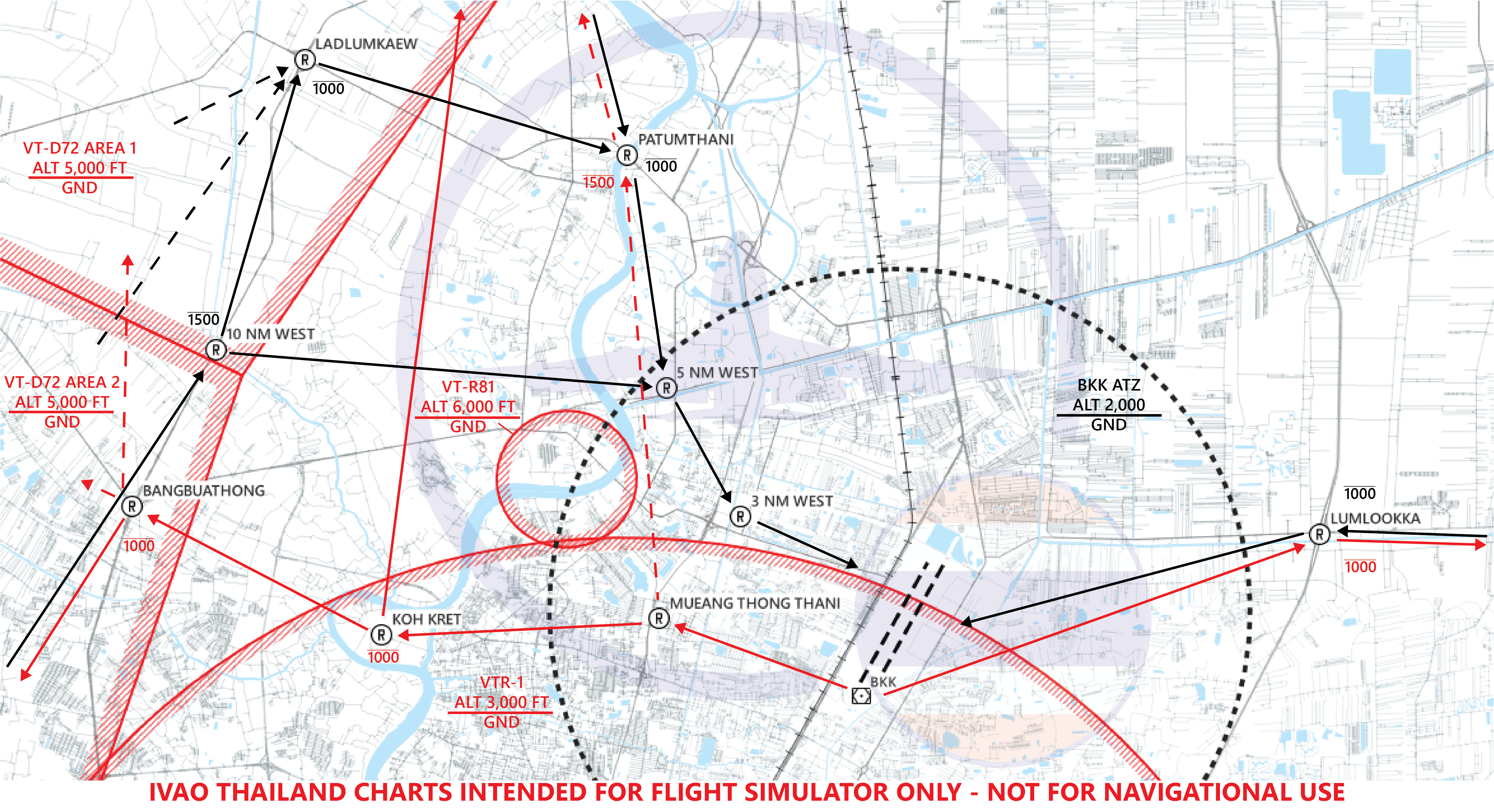
¶ Reporting Point
| Reporting Point | Pronounciation | Landmark | Radial/DME from BKK VOR | Lat/Long |
|---|---|---|---|---|
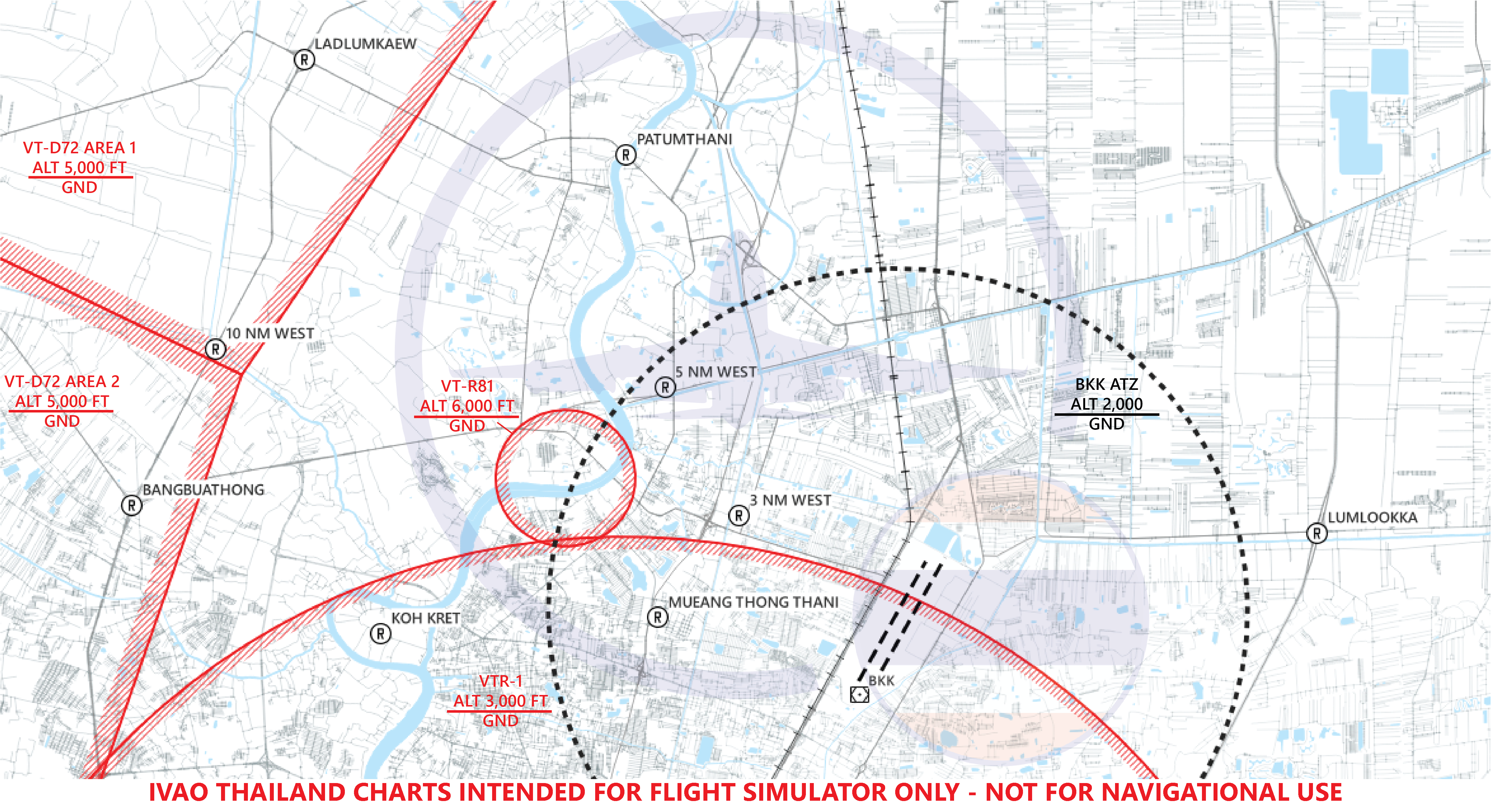
| 3 NM WEST | 3 - MILE - WEST | Armed Forces Development Command (Dome shape) | R317/3.14D | 135556N 1003295E |
| 5 NM WEST | 5 - MILE - WEST | Government Housing Complex Tiwanon (Ban Uea Athon Tiwanon) | R331/5.5D | 135815N 1003254E |
| 10 NM WEST | 10 - MILE - WEST | Bangkok Western Outer Ring Rd. crossing Pra-u-dom canal | R298/10.5D | 135843N 1002618E |
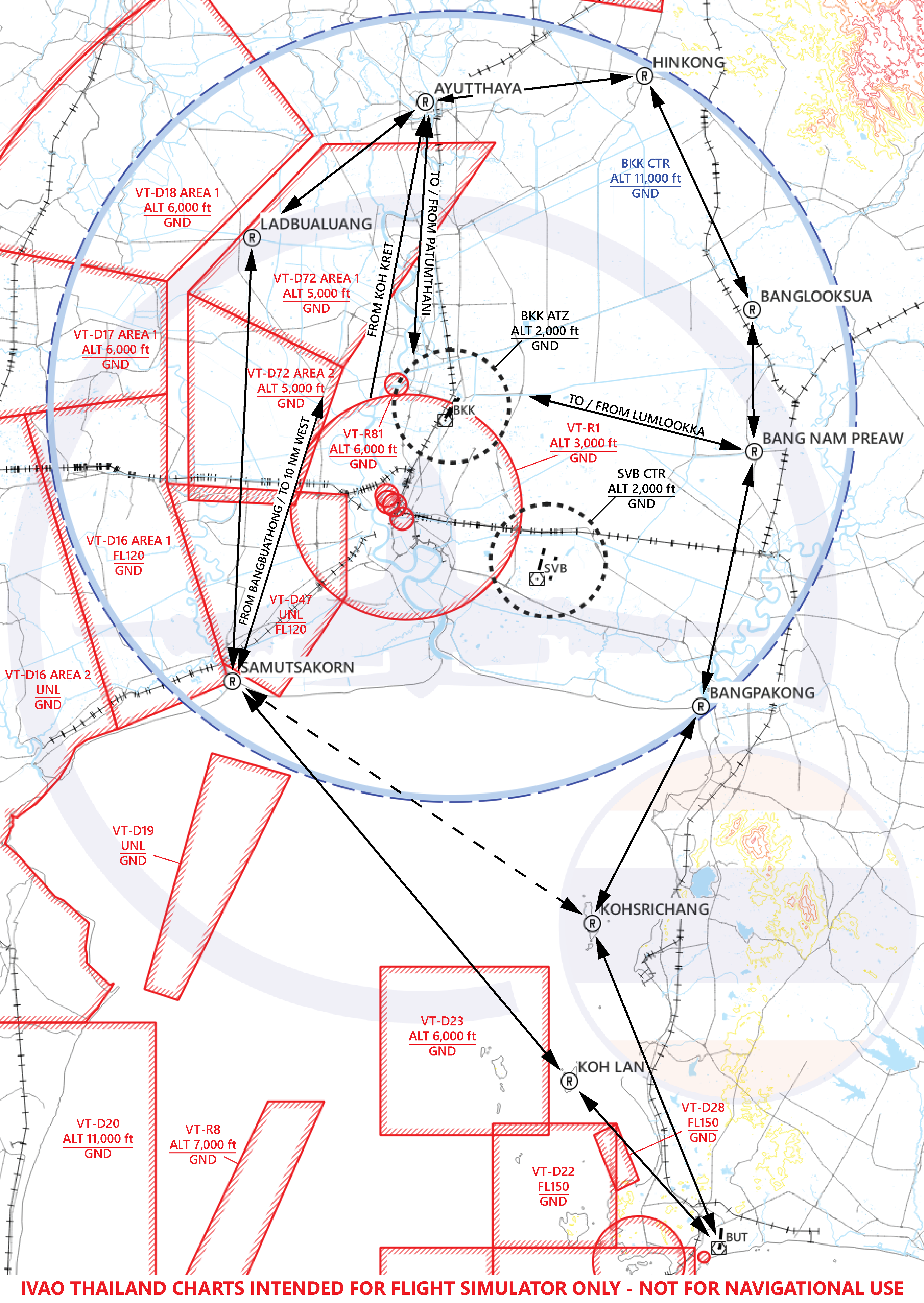
| AYUTTHAYA | A - YUT - THA - YA | Preedee Panomyong Bridge (Ayutthaya Downtown) | R356/28.32D | 142200N 1003400E |
| BANGBUATHONG | BANG - BUA - THONG | Bangkok Western Outer Ring Rd. crossing the Highway 345 (Bang Bua Thong Interchange) | R284/10.15D | 135610N 1002540E |
| BANGLOOKSUA | BANG - LOOK - SUA | Pradhana Vanalai Studio | R070/29.0D | 140310N 1010404E |
| BANG NAM PREAW | BANG - NAM - PRIAO | Bang Nam Priao District Office | R097/26.4D | 135014N 1010210E |
| BANGPAKONG | BANG - PA - KONG | Bang Pa Kong River Delta | R137/34.3D | 132809N 1005945E |
| HINKONG | HIN - KONG | Racetrack Ring Highway Interchange (Hin Kong Interchange) | R028/34.86D | 142430N 1005240E |
| KOH LAN | KOH - LAN | Koh Lan Island | R169/59D | 125453N 1004649E |
| KOHSRICHANG | KOH - SI - CHANG | Koh Sichang Island | R167/45.00D | 130745N 1004840E |
| LADBUALUANG | LAD - BUA - LUANG | Lat Bua Luang District Office | R314/23.5D | 140957N 1001814E |
| LADLUMKAEW | LAD - LUM - KAEW | Bangkok Western Outer Ring Rd. crossing the Highway 346 | R319/12D | 140245N 1002746E |
| LUMLOOKKA | LUM - LOOK - KA | Bangkok Eastern Outer Ring Rd. crossing Lumlookka Rd. (Lam Luk Ka Interchange) | R070/7.42D | 135609N 1004257E |
| KOH KRET | KOH - KRET | Koh Kret Island | R289/6D | 135529N 1002953E |
| MUEANG THONG THANI | MUEANG - THONG - THA - NI | IMPACT Exhibition Center | R239/6.9D | 134958N 1002943E |
| PATUMTHANI | PA - TUM - THA - NI | Patumthani Bridge 1 (Crossing Chaopraya River) (Not to be confused with Patumthani Bridge 2) | R341/8.74D | 140156N 1003255E |
| SAMUTSAKORN | SA - MUT - SA - KORN | Tha Chin River Delta (Not to be mistaken with Mae Klong River Delta) | R221/27.48D | 133300N 1001700E |
VFR reporting point near Don Mueang International Airport.
VFR reporting point inside Bangkok TMA.
¶ Entry Procedure
| Entry Point | Reporting Point for Entry / Altitude | |||
|---|---|---|---|---|
| AYUTTHAYA (North) BELOW 2,000 ft |
PATUMTHANI BELOW 1,000 ft |
5 NM WEST BELOW 1,000 ft |
3 NM WEST BELOW 1,000 ft |
- |
| HINKONG (Northeast) ABOVE 4,500 ft |
AYUTTHAYA BELOW 2,000 ft |
PATUMTHANI BELOW 1,000 ft |
5 NM WEST BELOW 1,000 ft |
3 NM WEST BELOW 1,000 ft |
| BANGLOOKSUA (East) BELOW 1,500 ft |
BANG NAM PREAW BELOW 1,000 ft |
LUMLOOKKA BELOW 1,000 ft |
- | - |
| BANG NAM PREAW (East) BELOW 1,000 ft |
LUMLOOKKA BELOW 1,000 ft |
- | - | - |
| BANGPAKONG (Southeast) BELOW 1,500 ft |
BANG NAM PREAW BELOW 1,000 ft |
LUMLOOKKA BELOW 1,000 ft |
- | - |
| KOH LAN (Southeast) BELOW 2,000 ft |
SAMUTSAKORN BELOW 2,000 ft |
10 NM WEST 1,500 ft |
5 NM WEST BELOW 1,000 ft |
3 NM WEST BELOW 1,000 ft |
| KOHSRICHANG(*) (Southeast) 2,000 ft |
SAMUTSAKORN BELOW 2,000 ft |
10 NM WEST 1,500 ft |
5 NM WEST BELOW 1,000 ft |
3 NM WEST BELOW 1,000 ft |
| SAMUTSAKORN (Southwest) BELOW 2,000 ft |
10 NM WEST 1,500 ft |
5 NM WEST BELOW 1,000 ft |
3 NM WEST BELOW 1,000 ft |
- |
| LADBUALUANG (West) | LADLUMKAEW BELOW 1,000 ft |
PATUMTHANI BELOW 1,000 ft |
5 NM WEST BELOW 1,000 ft |
3 NM WEST BELOW 1,000 ft |
Note: (*) When VTD 22 or VTD 23 active, U-TAPAO Approach will assign the aircraft to report over KOH SRICHANG reporting point.
At 5 NM WEST / LUMLOOKKA arriving aircraft will be instructed to contact Don Mueang Tower on 118.100.
After 3 NM WEST / LUMLOOKKA arriving aircraft will be instructed to join circuit pattern for runway 03/21.
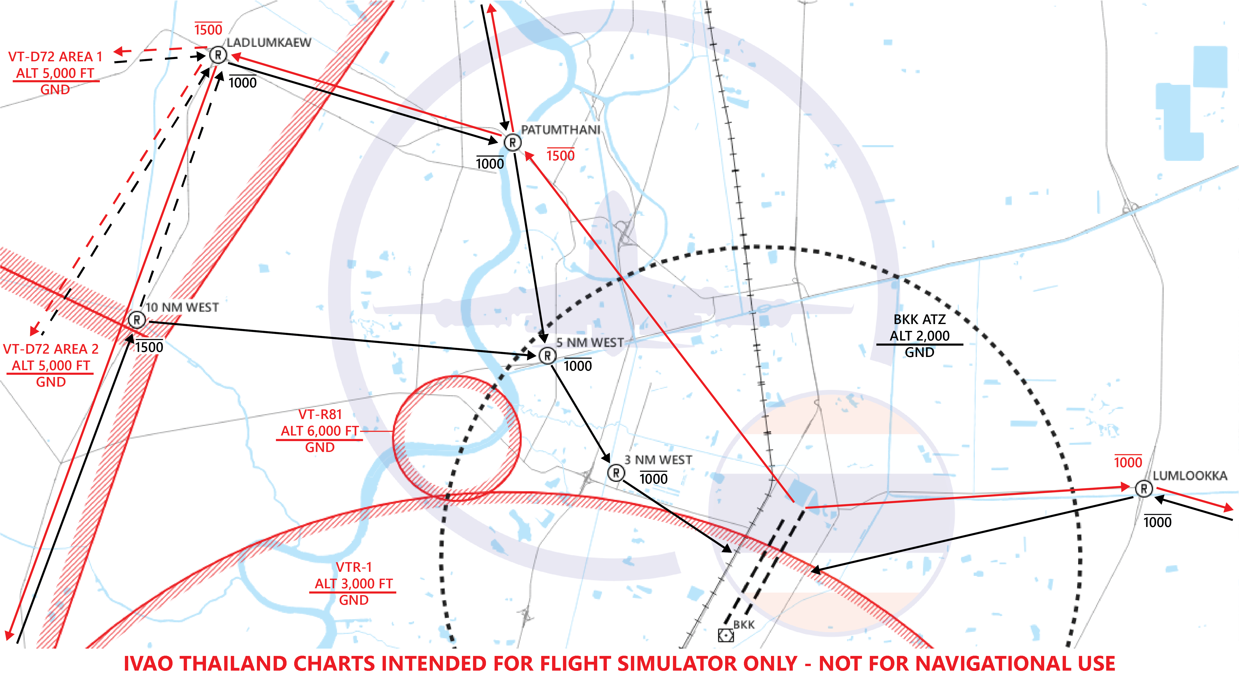
¶ Exit Procedure
¶ Runway 21L/R
| Direction of Flight | Reporting Point for Exit / Altitude | ||||
|---|---|---|---|---|---|
| North | MUEANG THONG THANI | KOH KRET BELOW 1,000 ft |
AYUTTHAYA BELOW 2,500 ft |
- | - |
| North* | MUEANG THONG THANI | PATUMTHANI BELOW 1,500 ft |
AYUTTHAYA BELOW 2,500 ft |
- | - |
| Northeast | MUEANG THONG THANI | KOH KRET BELOW 1,000 ft |
AYUTTHAYA BELOW 2,500 ft |
HINKONG BELOW 3,500 ft |
- |
| Northeast* | MUEANG THONG THANI | PATUMTHANI BELOW 1,500 ft |
AYUTTHAYA BELOW 2,500 ft |
HINKONG BELOW 3,500 ft |
- |
| East | LUMLOOKKA BELOW 1,000 ft |
BANG NAM PREAW BELOW 1,000 ft |
- | - | - |
| Southeast (1) | LUMLOOKKA BELOW 1,000 ft |
BANG NAM PREAW BELOW 1,000 ft |
BANGPAKONG BELOW 1,500 ft |
- | - |
| Southeast (2)** | MUEANG THONG THANI | KOH KRET BELOW 1,000 ft |
BANGBUATHONG BELOW 1,000 ft |
SAMUTSAKORN BELOW 2,500 ft |
KOHSRICHANG ABOVE 3,500 ft |
| Southeast (3) | MUEANG THONG THANI | KOH KRET BELOW 1,000 ft |
BANGBUATHONG BELOW 1,000 ft |
SAMUTSAKORN BELOW 2,500 ft |
KOH LAN ABOVE 2,500 ft |
| Southwest | MUEANG THONG THANI | KOH KRET BELOW 1,000 ft |
BANGBUATHONG BELOW 1,000 ft |
SAMUTSAKORN BELOW 2,500 ft |
- |
| West | MUEANG THONG THANI | KOH KRET BELOW 1,000 ft |
BANGBUATHONG BELOW 1,000 ft |
- | - |
Note: (*) Optimal route for exit, can only be use when there is no traffic inbound.
Note: (**) When VT-D22 or VT-D23 active, U-TAPAO Approach will assign the aircraft to report over KOH SRICHANG reporting point.
At MUEANG THONG THANI / LUMLOOKKA departing aircraft will be instructed to contact Approach Controller.
¶ Runway 03L/R
| Direction of Flight | Reporting Point for Exit / Altitude | |||
|---|---|---|---|---|
| North | PATUMTHANI BELOW 1,500 ft |
AYUTTHAYA BELOW 2,500 ft |
- | - |
| Northeast | PATUMTHANI BELOW 1,500 ft |
AYUTTHAYA BELOW 2,500 ft |
HINKONG BELOW 3,500 ft |
- |
| East | LUMLOOKKA BELOW 1,000 ft |
BANG NAM PREAW BELOW 1,000 ft |
- | - |
| Southeast (1) | LUMLOOKKA BELOW 1,000 ft |
BANG NAM PREAW BELOW 1,000 ft |
BANGPAKONG BELOW 1,500 ft |
- |
| Southeast (2)* | PATUMTHANI BELOW 1,500 ft |
LADLUMKAEW BELOW 1,500 ft |
SAMUTSAKORN BELOW 2,500 ft |
KOHSRICHANG ABOVE 3,500 ft |
| Southeast (3) | PATUMTHANI BELOW 1,500 ft |
LADLUMKAEW BELOW 1,500 ft |
SAMUTSAKORN BELOW 2,500 ft |
KOH LAN ABOVE 2,500 ft |
| Southwest | PATUMTHANI BELOW 1,500 ft |
LADLUMKAEW BELOW 1,500 ft |
SAMUTSAKORN BELOW 2,500 ft |
- |
| West | PATUMTHANI BELOW 1,500 ft |
LADLUMKAEW BELOW 1,500 ft |
- | - |
Note: (*) When VT-D22 or VT-D23 active, U-TAPAO Approach will assign the aircraft to report over KOH SRICHANG reporting point.
At PATUMTHANI / LUMLOOKKA departing aircraft will be instructed to contact Approach Controller.
Revision: AIRAC 2307 (3 July 2023)
- ENR 1.10 FLIGHT PLANNING
- ENR 2.1 FIR, UIR, TMA
- AD 2 Aerodromes, VTBD
- VID 480952 - Creation
- This documentation is copyrighted as part of the intellectual property of the International Virtual Aviation Organisation.
- The content of this documentation is intended for aviation simulation only and must not be used for real aviation operations.