Tel Aviv / Ben Gurion
¶ 1 Information
Check the applicable ATIS before connecting to any frequency. During events most frequencies are active, but not all. Check NOTAM and event information during your flight planning.
ICAO-code LLBG
IATA-code TLV
Elevation 135 ft / 41 m
Coordinates 32.08°N 34.78°E
Transition Altitude (TA) 10500 FT
commonly known by the Hebrew-language acronym Natbag (נתב״ג), is the main international airport of Israel. Situated on the northern outskirts of the city of Lod, it is the busiest airport in the country. It is located 45 kilometres (28 mi) to the northwest of Jerusalem and 20 kilometres (12 mi) to the southeast of Tel Aviv.[2] Until 1973, it was known as Lod Airport, whereafter it was renamed in honour of David Ben-Gurion (1886–1973), the first Israeli prime minister. The airport serves as a hub for El Al, Israir Airlines, Arkia, and Sun d'Or, and is managed by the Israel Airports Authority.
LLBG Tel Aviv FIR (LLLL)
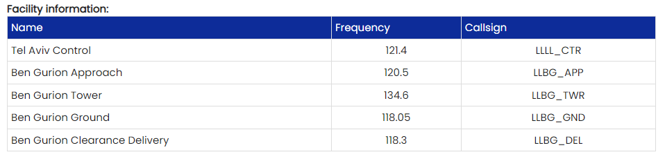
¶ 2 Communications Frequencies
Check the applicable ATIS before connecting to any frequency. During events most frequencies are active, but not all. Check NOTAM and event information during your flight planning.
¶ 2.1 Ground, parking and taxi information
Departing IFR flights shall contact tower to obtain ATC clearance before commencing start up or taxi.
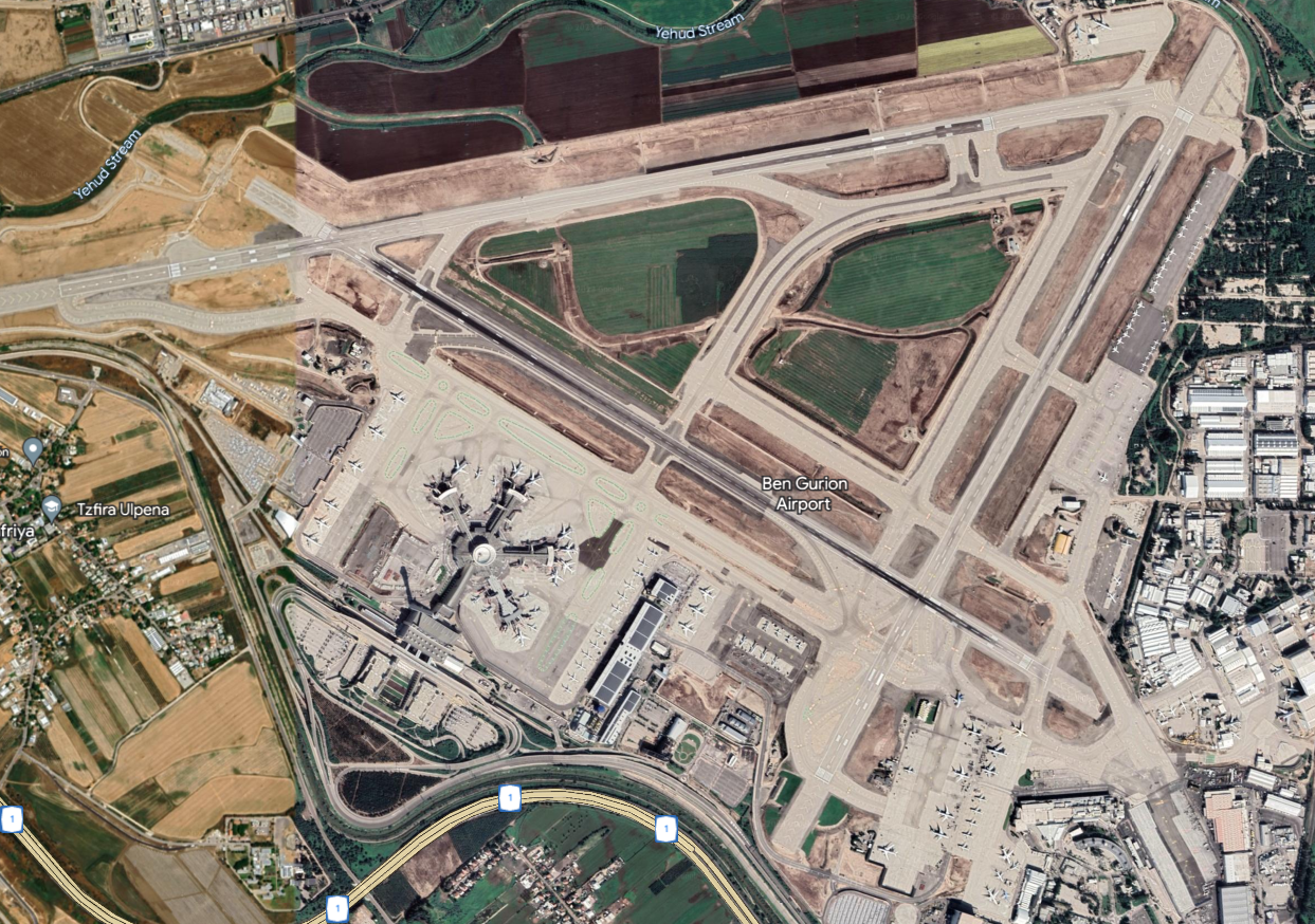
Airport Diagram
PREFERENTIAL RUNWAY SYSTEM RWY 26/08 is the only available RWY for landing and take-off.
ARRIVALS RWY 26 will be the preferred RWY assigned to landing ACFT, between sunrise and 30 minutes before sunset provided the tailwind component does not exceed 10 KT when RWY is dry or 5 KT when RWY is wet. RWY 08 will be the preferred RWY assigned to landing ACFT, between 30 minutes before sunset and sunrise, provided the tailwind component does not exceed 10 KT when the RWY is dry or 5 KT when RWY is wet.
DEPARTURES RWYs 26 and 08 will be preferred RWYs assigned to departing ACFT, provided the tailwind component does not exceed 5 KT when RWY is wet. LANDING - TAKE-OFF The following combinations might be used: a) 26 - 26 b) 08 - 08.
TAXI PROCEDURES
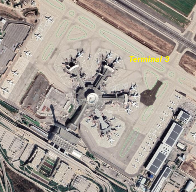
GENERAL Apron A to be used by towing only.
Apron V to be used by ATC instructions only.
ACFT being towed from Terminal 1 to Terminal 3 and vice versa, must establish and maintain communication with BEN GURION Ground.
When towed from Terminal 1 to Terminal 3 contact Ground East; from Terminal 3 to Terminal 1 contact Ground West.
When Ground West and Ground East are combined use frequency 129.2.
Terminal Most Popular
RWYs Information
Runway 08/26
| Dimensions: | 13327 x 148 feet / 4062 x 45 meters | |
|---|---|---|
| Surface: | Hard | |
| Runway 08 | Runway 26 | |
| Coordinates: | N32°0.77' / E34°51.65' | N32°1.06' / E34°53.56' |
| Elevation: | 97 | 124 |
| Runway Heading: | 076° | 255° |
| Displaced Threshold: | 1322 Feet | 1982 Feet |
Runway 12/30
| Dimensions: | 10210 x 148 feet / 3112 x 45 meters | |
|---|---|---|
| Surface: | Unknown | |
| Runway 12 | Runway 30 | |
| Coordinates: | N32°0.85' / E34°52.01' | N31°60.00' / E34°53.65' |
| Elevation: | 102 | 130 |
| Runway Heading: | 116° | 296° |
| Displaced Threshold: | 243 Feet | |
Runway 03/21
| Dimensions: | 9094 x 197 feet / 2772 x 60 meters | |
|---|---|---|
| Surface: | Unknown | |
| Runway 03 | Runway 21 | |
| Coordinates: | N31°59.77' / E34°53.16' | N32°1.09' / E34°54.01' |
| Elevation: | 134 | 134 |
| Runway Heading: | 024° | 204° |
Nearby Navigation Aids
ID Name Freq Radial / Range
VOD BGN BEN-GURION 113.50 107° 0.6
VOD NAT NATANIA 112.40 187° 19.9
VOD BSA BEER-SHEBA 114.30 005° 44.1
VOD MZD METZADA 115.00 322° 48.1
ID Name Freq Bearing / Range
VOD BGN BEN GURION 309 073° 3.6
VOD TAV TEL AVIV 348 318° 8.1
VOD IRM JERUSALEM 336 117° 19.0
VOD JYG JERICHO 307 107° 31.2
Nearby Airports with Instrument Procedures
| ID | Name | Heading / Distance | ||
 |
LLHA | Haifa Airport | 009° | 48.5 |
|
|
OJAM | Amman Airport | 091° | 56.5 |
|
|
OJAI | Queen Alia-Amman Airport | 106° | 59.2 |
|
|
HEAR | El Arish International Airport | 224° | 77.7 |
|
|
OLBA | Rafic Hariri Beirut International Airport | 015° | 112.6 |
|
|
OSDI | Damascus International Airport | 044° | 117.6 |
|
|
OEGT | Guriat Domestic Airport | 105° | 127.6 |
|
|
HEPS | Port Said Airport | 252° | 142.4 |