¶ Special Operations Instruction No. 4 - Creating airspace restrictions and reservations
¶ Introduction
These reserved airspace will be established by IVAO divisions and may be used by SO pilots to perform dangerous activities as per SO reg 4. These areas shall if possible be based off real airspace structure where possible. But with this said consideration shall be made to the limitations of IVAO and its systems.
Areas can be created as a permanent area (SO Order) or temporarily for things such as tours, events or on the request of Special operations groups.
¶ Area Types
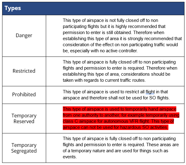
Below is a list of all the types of areas that are recognised on IVAO, and a description of the restrictions they apply.

¶ Information Required
Area shall be defined by the minimum information below;
-
Area Name
The name should be unique -
Area Type
Danger/Restricted/TRA/TSA
¶ Conditions of use
Below are the conditions of use that shall be used on all airspace on IVAO, after this piece of text on a new line, extra text may be added.
- anger areas
“Reserved and designated for exclusive use by SO flights only, crossing allowed at pilots own risk.”
- TRA
“Temporarily under the Authority of ABC, refer to NOTAM XYZ”
- Prohibited
“Restricted to all aircraft”
- Other areas
This shall always be “Reserved and designated for exclusive use by SO flights only”
¶ Lateral Limits
This shall be one of 2 shape either;
- Simple Polygon
Defined by the corner points of the area, and the first and last point creating a closed shape.
Example:“255000N0455000W–300000N0455000W–300000N0500000W–300000N0455000W–255000N0455000W–255000N0455000W”
- Circle
Defined by the center point and the radius from this point in nautical miles.
Example: “15NM RADIUS OF 255000N0455000W”
The area shall not be a combination of these shapes and must have defined points.
The use of nav aids and airspace borders are also not suitable definitions.
¶ Vertical limits
The area shall be defined by a higher and lower limits using any of the altitude formats below:
- 100ft AMSL
- 100ft
- SFC
- FL100
- UNL
Meters may be used but perversion of feet as well would be preferred.
Areas published in the SO order must have set vertical limits.
¶ Activation Details
Areas must use one of the activation types stated below
¶ Permanently Active
This shall be used sparingly, as can be disruptive to none SO pilots.
Text that shall always be used for this type “Permanently Active”
¶ Time specific
This shall be used if the area is to be opened at set times and days. No exemptions for holiday days shall be made. Format to be used is as the examples below:
MON/TUE/FRI 1200-1900z
MON-TUE 12-19z , WED 13-15z
¶ NOTAM
These areas will be opened by a NOTAM by the division staff. This type of activation can be requested by IVAO users and SOG with a minimum 48h notice.
This notice shall be by email.
Text that shall be used for this type “By NOTAM (on email request at least 48 hours in advance from IVAO users)"
¶ ATC activation
This type of activation can be used in conjunction with the other types or used by itself.
Only Area/Center controllers may activate a restricted area that is within their area of responsibility. This shall be mentioned in the controller's remarks.
¶ Data Format
Bellow are the formats that shall be used when defining Areas.
¶ Date
The week days shall use format as stated below
MON = Monday
TUE = Tuesday
WED = Wednesday
THU = Thursday
FIR = Friday
SAT = Saturday
SUN = Sunday
Dates shall use format below to avoid confusion;
04-FEB-2021
¶ Time
All time shall be given in UTC (zulu) time in one of the two formats bellow:
1000-1530z
10-15z
¶ Coordinates
Coordinates shall be in Degrees,Minutes,Seconds (DMS), in 6 digits format,
For example:
514605N0103227W-513530N0101801W-514605N0103227W
There shall be no spaces and every waypoint shall have a “-” between them, also the last and first point shall also be the same to close the shape.
For Example:
514605N0103227W-513530N0101801W-514605N0103227W-514605N0103227W
¶ Using the data.ivao.aero website
All Airspace restrictions that are created whether that be permanent or temporary shall be published in the Data website.
¶ Adding Airspace
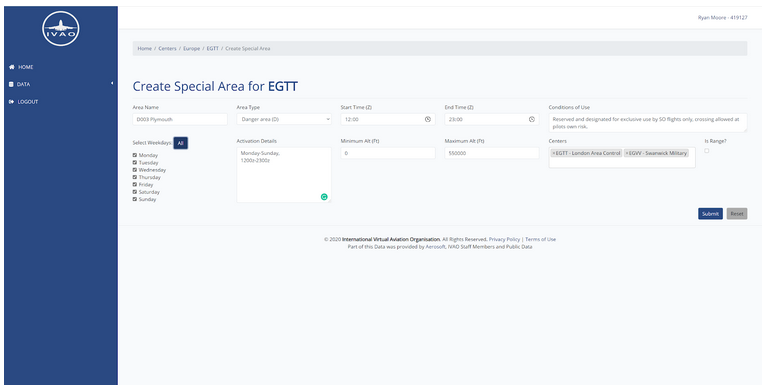
Airspace restrictions are connected to at least one center (FIR) and therefore under the center page is where you will find Special Areas.
The data shall be filled in using the same data as present in the divisional SO order.
Points to note:
Leave times empty for a permanent activation
To set the Minimum alt to surface, set the value to “0”
For unlimited Altitude set value to “99,999”
Multiple centers (FIR’s) may be added
Area shape can be added it has been added
Circles can not be added to the map shape and therefore a a circle must be drawn with multiple points.
Example:

¶ Editing Areas shape
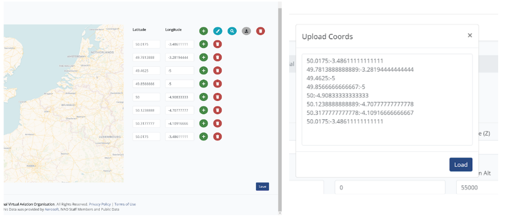
The coordinates that should be imputed are in a decimal format and therefore the data from a SO order must be converted to this format.
Individual waypoints can be added one by one using the green “+” button.
Multiple waypoints can be added using the gray button, and of the format :
LAT:LON
LAT:LON
Once added the area will be seen in red on the map at the top of the Center(FIR’s) page.

¶ Update Log
| Ver. | Date | Name | Overview of change(s) |
|---|---|---|---|
| 1.0 | 22 July 2024 | Jan Weil (IVAO-SOAD) | Migration to the Wiki |