¶ Introduction
The flight strip management for ATC is an important point in order to ensure aircraft management and improve safety when controlling.
In real aviation, a flight strip is a small strip of paper used to track a flight in air traffic control (ATC).
It is still used in modern ATC as a quick way to annotate a flight, to keep a legal record of the instructions that were issued, to allow other controllers to see instantly what is happening and to pass this information to other controllers who go on to control the flight.
In the modern ATC, the use of paper flight strips disappears to be replaced by electronic flight strips displayed on specific computers.
¶ Flight strip and label representation
¶ Flight strip representation
The flight strip contains the extract of flight plan data plus some extra labels.
In IVAO, a flight strip is represented like this:

An example of a real flight strip:

We present you one type of flight strip, but there are several layouts available around the world. IVAO has selected one of those.
¶ Labels representation
Labels are data inserted in a flight strip by the air traffic controller in order to help him to:
- Manage the aircraft
- Remember the clearance given by himself
- Receiving clearance given by other ATC without any additional chat
- Sending to the next ATC the clearance given to aircraft without any additional chat
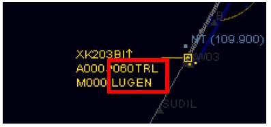
The labels are located in the zone highlighted by the red square.
In the example below, labels are 060 and LUGEN:

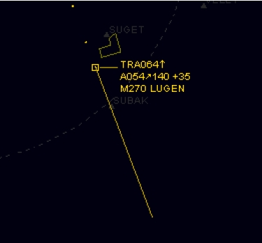
After inserting the labels, the aircraft representation on radar will be:

In the example below, labels are empty:

ATC shall maintain only necessary current data on the strip and remove the label from the flight strip when no longer required for control purposes.
We advise you to select the option "Remove clearance on RELEASE" in the label route options.
¶ Labels type
There are 2 labels in a flight strip:
- Waypoint label
- Flight level or altitude label
In our example:
- Waypoint label = LUGEN
- Flight level label = 060

¶ Use of label at approach or departure position
In this chapter, we will present only the approach or departure point of view.
¶ Departure handling
When controlling IFR aircraft, you shall verify at first contact that the waypoint and flight level or altitude labels are compatible with the departure given.

These labels are very important for an approach controller and/or a departure controller in order to anticipate the potential separation loss.
For VFR aircraft, the label is important in order to know where the aircraft is going in order to anticipate any potential future conflict in the tower area.

¶ Climbing clearance
During climb, the controller will give climbing clearance to the aircraft.
The controller shall update the label with the cleared fix and altitude in order to send information of the clearance given for the next controller.

Note: If there is no next controller, the controller can use labels for himself in order to increase the security of the traffic under his responsibility.
¶ Arrival handling
As an approach controller, you will receive the IFR aircraft from the en-route controller. The label should already have been inserted by the en-route controller.
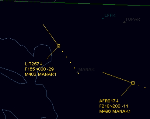
You could have this type of example:
- Flight level or altitude label can be the first descent flight level or altitude.
- Waypoint can be the cleared fix or arrival procedure.

In the example, there are two aircraft performing STAR MANAK1 inserted in the waypoint label. The first one has a cleared descent down to FL080 and the second one has a cleared descent down to FL200.
These labels can be used to:
- verify the aircraft on respecting the clearance given
- improve the security of your airspace in order to detect and prevent the potential loss of separation
¶ Descending to final approach
As an approach controller, you must fill the labels for the final approach phase of each flight in order to communicate information to the next controller (tower controller).
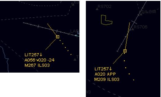
You could have this type of example:
- The altitude label can be put on the interception altitude or specific APP label when cleared for the IFR approach.
- The waypoint altitude can be the runway number for landing and/or the IFR approach type performed.

In our examples, you can see the "020" clearance which is 2000ft descent clearance to the final interception altitude. You can also see the "ILS03" label which is stating that the aircraft will perform an ILS approach on runway 03. These are examples; other labels can be made and decided upon between active controllers.
¶ Radar Vectoring
In some areas, the approach controller can or shall vector the aircraft in order to make a regulation sequence or optimize the traffic flow.
In the examples below, there are different types of labels which can be used for tagging these aircraft which are under radar control by one air traffic controller:
- Use the term RDR as radar followed by the cleared heading (example RDR300)
- Use the tag "°" as degrees by inserting the cleared heading followed by this tag (example 360°)
- Use only the term RDR with no cleared heading when the air traffic controller should remind the parameters given

- None
- None
- VID 150259 - Creation
- VID 531824 - Wiki Integration
- VID 496402 - Wiki.js integration