¶ Introduction
The flight strip management for ATC is an important point in order to ensure aircraft management and improve safety when controlling.
In real aviation, a flight strip is a small strip of paper used to track a flight in air traffic control (ATC).
It is still used in modern ATC as a quick way to annotate a flight, to keep a legal record of the instructions that were issued, to allow other controllers to see instantly what is happening and to pass this information to other controllers who go on to control the flight.
In the modern ATC, the use of paper flight strips disappears to be replaced by electronic flight strips displayed on specific computers.
¶ Flight strip and label representation
¶ Flight strip representation
The flight strip contains the extract of flight plan data plus some extra labels.
In IVAO, a flight strip is represented like this:

An example of a real flight strip:

We present you one type of flight strip, but there are several layouts available around the world.
¶ Labels representation
Labels are data inserted in a flight strip by the air traffic controller in order to help him to:
- Manage the aircraft
- Remember the clearance given by himself
- Receiving clearance given by other ATC without any additional chat
- Sending to the next ATC the clearance given to aircraft without any additional chat
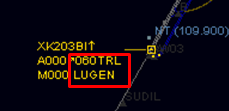
The labels are located in the zone highlighted by the red square. In the example below, labels are 060 and LUGEN:

After inserting the labels, the aircraft representation on radar will be
In the example below, labels are empty:

ATC shall maintain only necessary current data on the strip and remove the label from the flight strip when no longer required for control purposes.
We advise you to select the option "Remove clearance on RELEASE" in the label route options.
¶ Labels type
There are 2 labels in a flight strip:
- Waypoint label
- Flight level or altitude label
In our example:
- Waypoint label = LUGEN
- Flight level label = 060

¶ Use of label at ground or delivery position
¶ For IFR management
The goal of ground management with each IFR aircraft is to give him the clearance and instruct the aircraft to taxi to the runway in use for take-off.
The initial IFR clearance is the most important thing to give to an IFR aircraft on ground. It normally includes: IFR departure procedure, runway for take-off, initial climb flight level or altitude, transponder code.
The best way on ground is to prepare and set useful data in labels for new air traffic controller (ATC). The useful data for IFR flight is the clearance.
The labels can be updated at any time:
- Just after the connection
- When the initial radio contact has been made
- After the initial IFR clearance read-back
- When aircraft will start taxi
- Just before the transfer to the tower or at holding point.
For efficiency in the ground management, we recommend to update the label after the clearance is well read back by the pilot.
This has several advantages:
- Ground controller knows if the IFR clearance has been delivered to a pilot. This will not create confusion to the pilot if ground controller asks if he has got his clearance!
- Ground controller knows if the pilot will be moving shortly or not. A pilot who has received his clearance will ask a pushback or a taxi in a shorter period of time than a pilot who hasn't.
- Departure information in labels will prepare the useful data in order to handle the taking off and climbing phase of the aircraft in the best way.
What information do you set in the labels areas?
- For the flight level or altitude label, you insert the initial flight level or altitude cleared (given by approach controller or a published one...) in hundreds of feet.
- For the waypoint, you insert the SID designation, the last point of the SID (SID given in the initial IFR clearance), or the point cleared in omnidirectional departure.
If you prefer inserting the SID, pay attention that the label area is limited to 6 characters and sometimes the SID must be shortened.
¶ Example IFR management
In our examples below, we will have both IFR aircraft:


Figure below: the In/Out window shows 2 outbound IFR aircraft from LFRS airfield
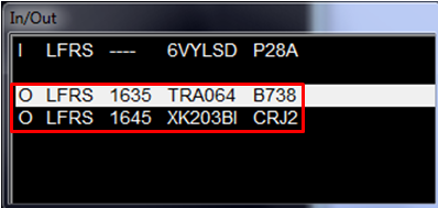
The first aircraft will ask clearance; after read back we insert the data in the labels:

The second aircraft will ask clearance; after read back we insert the data in the label of this second aircraft:

Notice that In/Out windows has also been updated with these labels:
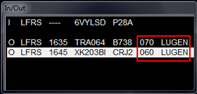
Figure below is just showing 2 IFR aircraft on the ground, one moving and the other one at the gate:
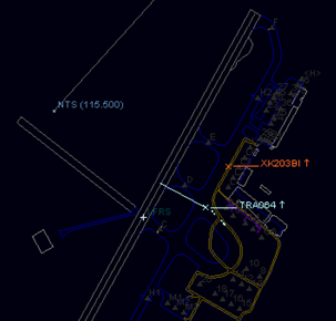
Note that when the aircraft transponder mode is stand-by (STBY), the aircraft labels are not shown.
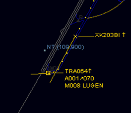
When the aircraft sets his transponder mode to alticoder (TX, or sometimes named Sierra or Charlie), the labels set by the air traffic controller are displayed on the radar screen (here 070 and LUGEN).
¶ For VFR management
The goal of ground management with VFR aircraft is to know what is the purpose of each VFR flight, especially when the route is not filled (route is optional for VFR flight except in some particular conditions). When the air traffic controller knows exactly the intention of aircraft, he can instruct the aircraft to taxi to the runway in use for take-off.
The best way on ground is to prepare and set useful data in labels for new air traffic controller (ATC). The useful data for VFR flights can be the VFR exit points, first destination point, or VFR manoeuver type.
The labels can be updated at any time:
- Just after the connection
- When the initial radio contact has been made
- After the VFR clearance read-back
- When aircraft will start taxi
- Just before the transfer with the tower or at holding point.
For efficiency in the ground management, we recommend to update the label after the first clearance is well read back by the pilot (before the taxi).
This has several advantages:
- Ground controller knows if the first clearance has been delivered to a pilot. This will not create confusion to the pilot if ground controller asks if he has got his clearance!
- Ground controller knows if the pilot will be moving shortly or not. A pilot who has received his clearance will ask a taxi in a shorter period of time than a pilot who hasn't.
- Departure information in labels will prepare the useful data in order to handle the taking off and climbing phase of the aircraft in the best way.
What information do you set in the labels areas?
- For the flight level or altitude label, you insert the initial flight level or altitude cleared (given by approach controller or apu blished one...) in hundreds of feet. If there is no specific VFR altitude given, then leave this area blank.
- For the waypoint, you insert the VFR exit point, the area of evolution, or the first destination point, VFR exercise type.
¶ VFR example
You can use the published exit points like K, DW or published VFR tracks like NW1, SE3.

You can use magnetic coordinates like N, W, E, S or a combination of these like NW.

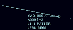
You can use the terms PATTER or PATTRN or another type of your choice if the aircraft wants to perform an aerodrome circuit pattern.

You can use the first destination point like airfield, fix, or radio navigation beacon or geographical landmark.


¶ Use of label at Tower position
In this chapter, we will present only the tower point of view. If the tower air traffic controller is in charge of the ground, he must read the previous chapter §3.
¶ Departure handling
When controlling IFR aircraft, you must be sure that the flight strip will include the right parameters for the next controller before the taking off clearance. You shall verify that the waypoint and flight level or altitude label are compatible with his departure given.

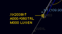
These labels are very important for an approach controller or a departure controller in order to anticipate the potential separation loss.
For VFR aircraft, the label is important in order to know where the aircraft is going in order to anticipate any potential future conflict in the tower area.

The air traffic controller can also put a label on aircraft which perform a traffic circuit pattern.

¶ Arrival handling
As a tower controller, you will receive the IFR aircraft from the approach. The label should already have been inserted by the approach.
You could have this type of example:
- The flight level or altitude label can be put on the interception altitude or specific APP label when cleared for the IFR approach.
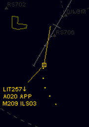
- The waypoint label can be the runway number for landing or the IFR approach type performed.
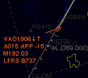
For arrival VFR aircraft, the approach controller could insert the entry point of the control zone of the tower ATC like the flight strip below:

In order to remind you of the incoming aircraft performing aerodrome traffic patterns on final, you can put a special label in the waypoint tab like the flight strip below.

- None
- None
- VID 150259 - Creation
- VID 150259 - Wiki Integration
- VID 496402 - Wiki.js integration