¶ Introduction
This document will explain the instrument approach charts named IAC charts.
These charts are used by pilots for performing initial, intermediate and final approach routes.
This document will show you some commented examples.
Be aware that each country has its own chart presentation. You need to catch your information using a quick analysis of the chart.
¶ Head of document
The head of document will show you the name and ICAO code of the applicable airfield, the type of chart.
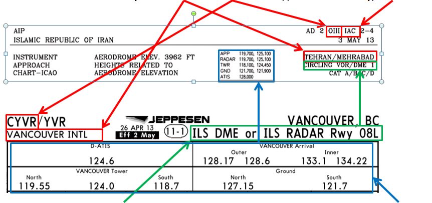
You will also find the name and the type of approach on the considered runway. There is a frequency list of available air traffic controllers for this approach.
Note: For IVAO, this table is not applicable. Only the frequencies of the connected air traffic controllers on the network are working and are usable by pilots.
¶ Head of the procedure charts
Below the head of document, there is some data and information for the pilot.
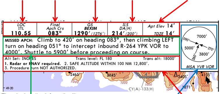
The chart extract below shows ILS parameters including:
Localizer frequency, course, glide scope altitude, ILS decision altitude, airport elevation altitude
There is also other information like
- Missed approach procedure description and minimum sector altitude
- Other information like : transition level and transition altitude, altitude setting unit and other parameters
Charts below can show other parameters due to the different type of approach.
The chart extract below shows VOR parameters including: VOR frequency, approach course, minimum check altitude, minimum descent altitude, airport elevation

There is also same information like the other chart:
- Missed approach procedure description and minimum sector altitude
- Other information like : transition level and transition altitude, altitude setting unit and other parameters
¶ Horizontal view of approach track on local chart
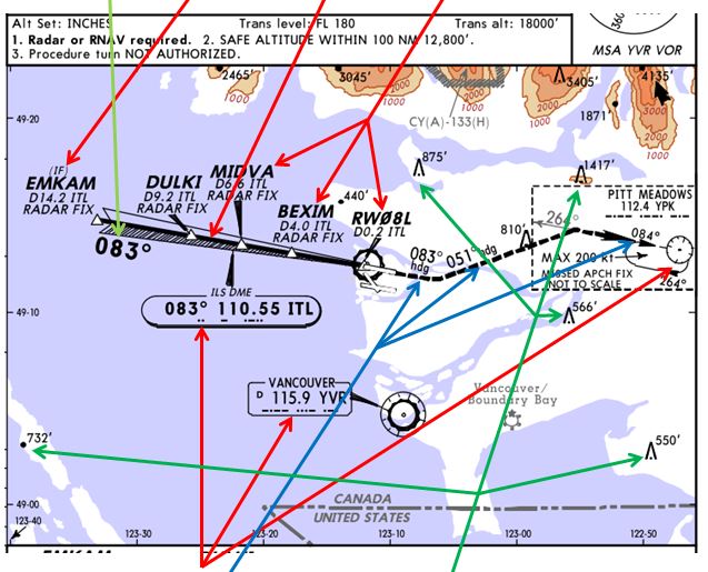
Each IAC chart has a horizontal view of the approach track. This view shows:
- The track (initial, intermediate and/or final track) including the different fixes on track
- The final course
- The navigation aids
- The go-around track (dotted line)
- The highest obstacle around the airfield in the area
if Another IAC chart has a different horizontal view. In this chart, we can identify a procedural turn in function of aircraft category where an aircraft is not coming in the same direction of the final approach track.
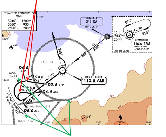
In this chart, you can also point out some limitation of certain flight parameters:
- Speed restriction
- DME distance restriction for procedure
- Specific zone depicted (like dangerous, restricted or prohibited ones).
¶ Vertical view of approach track including descent path
Each IAC chart has a vertical view of the approach track. This view shows the track; mainly the final approach track:
- the different fixes on track with distance from beacon (here ILS "ITL")
- the intermediate altitude for non-precision approach (localizer only)
- the interception altitude
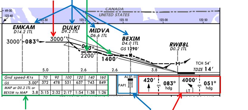
- a table with some information in function of ground speed
- Descent rate (feet/min)
- Timing for final approach (min:sec)
- the runway approach light type
- A summary of the initial missed approach procedure as a reminder
Another type of approach (VOR approach) can have a procedural turn. The overview of a procedural turn is represented like the image below:
- The procedural turn is usually made at steady altitude.
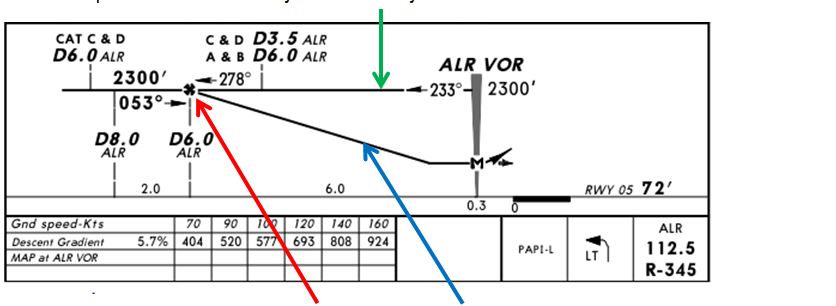
- The interception of the procedural turn and the descent path is made at one point (or at the end of the procedural turn)
You must combine the horizontal view of the chart with the vertical view in order to fly this procedure.
¶ Minima of IFR approach at the bottom of the chart
Each IAC chart has IFR approach minima which are located at the bottom of the chart. In this chart, there are minima of different types of approach applicable for this chart. ILS DME or ILS Radar approach, Localizer DME or Localizer Radar approach, Circle to land approach
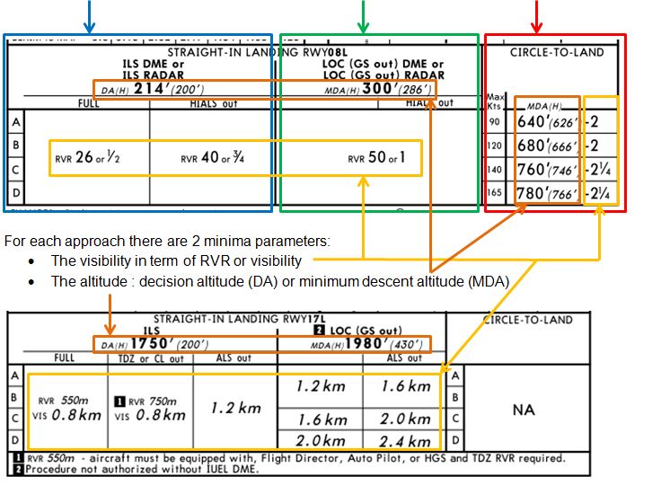
Note: The RVR (runway visibility range) or the visibility has different values on charts:
- Default unit is metre or kilometre: example RVR 550m / VIS 0.8 km
- Sometimes you will see other units: example RVR 26 or ½ = RVR 2600ft or ½SM
¶ Practical example
This is an example if of an ILS approach:
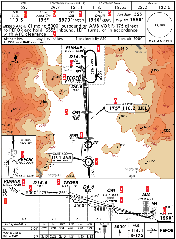

- Check ILS parameters: frequency and course
- Entry point PUMAR at FL70 and 22NM DME (intermediate approach) then start descent
- Descent down to 5000ft until TEGEB the start of descent (Final approach point) at 11NM DME
- Outer Marker (OM) point check. Pilot shall check 2970ft at 4.5NM DME
- Middle Marker (MM), pilot shall continue down to the decision altitude if he does not have the runway in sight
- Minima: Decision Altitude (DA), runway Visual Range (RVR) and Visibility (VIS) values
- Runway parameters
- Go around parameters
- ICAO documentation Annex 4 - Aeronautical Charts - 11th Edition July 2009
- VID 150259 - Creation
- VID 256272 - Wiki Integration
- VID 496402 - Wiki.js integration