¶ Introduction
In your daily IFR flight operations, you are planning to fly from one airfield to another one. Since the airspaces are getting more and more crowded, you cannot just takeoff, follow a straight line to your destination.
No, you need to fly your airplane according to regulations that order and optimize traffic flow. These regulations will require you to file a route, complying with several regulations.
The goal of this document is to teach you a methodology to build efficiently any typical medium haul flight routes flying through Europe. At the end, you should also be able to make your route compliant to any restrictions over the European airspace.
As this document has been written for training purposes, we will determine our route the hard way. No automatic route finder, nor flight planning software.
Instead, we will make our way through the various charts, documents and maps at our disposal in order to find an optimized route from our origin till our destination. AIP, Skyvector and the CFMU validator (only for Europe) will no longer hold any secret at the end of your reading.
¶ Route Building
¶ Generalities about the route
We are going to work out the following route: Paris CDG, France (LFPG) -- Budapest, Hungary (LHBP)
Why is it interesting to pick this route? It is for several reasons:
- It is going from one side to another of Europe which let us deal with a lot of restrictions
- Both airports have SIDs and STARs
- The flight is arriving in Hungary which has a "Free Route Airspace"
Finally, the flight is only 1 hour 40 minutes in average so it is not too long if you want to perform it, at the end of this tutorial.
Note that, as always, the elements of this route are subject to change in time due to AIRAC update each 28 days. The following route was created with AIRAC Publication 1511. Please take time to verify the validity of the route thoroughly before flying it.
¶ Step 1 -- Get the general direction
First of all, we will plot the great circle path between Paris CDG and Budapest.
This will allow us to:
- Determine the main direction and location of our flightpath for our flight
- Get the distance between our two airports
- Select our departure exit point, our airways and our arrival entry point.
Open SkyVector.com Click on flightplan. File the departure LFPG, and the destination LHBP. Then press enter. You can also file other fields if you want. For example we can fill the speed field to get the estimated flight time duration. At this point, it should be looking like that (if the background is not the same, just hit the "World Hi" button. It will display the world upper enroute chart.):
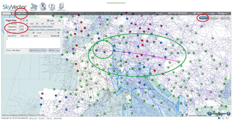
So, if we were to follow an orthodromy (the shortest route between two points on Earth), we would fly initially a track of 093°, and the flight would take us 676nm through Europe. The flight would last 1 hour 31 minutes at a ground speed of 450 knots. The forecast flightpath is shown in purple.
In the picture, do you see all that black and blue lines? They represent airways.
Most European airspace has elected to forbid a "Direct-To" path between two points. Therefore, IFR flights are required to fly along airways.
¶ Step 2 -- Determine our departure waypoint
Get to your chart directory and look for Standard Instrument Departures (SID).
Standard Instrument Departures are enforced at all major airports. They are published routes that lead from the runway to a departure exit waypoint.
We will use the national France AIP in order to find the adequate departure.
Let's assume that runways in use will be 08s and 09s. Also, let's consider that our aircraft is a modern twin-engine turbojet aircraft, with RNAV capability.
We open the corresponding chart: AD 2 LFPG SID RWY08L-09R -RNAV RANUX LANVI BUBLI DIKOL BAXIR
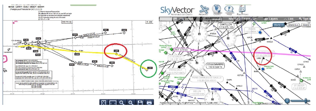
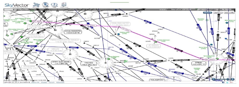
LASIV, one waypoint of the LANVI departure is close to the projected flightpath. As a consequence, we will plan our route, exiting Paris CDG airspace via LANVI. Plot the departure on SkyVector.
¶ Step 3 -- Determine our arrival waypoint
Get to your chart directory and look now for Standard Terminal Arrival Routes (STAR).
Standard Terminal Arrival Routes are enforced at all major airports.
They are published routes that lead from an arrival entry waypoint to the initial approach fix (IAF).
We will use the national Hungary AIP. You can see that Hungary has opted to regroup all STARs per runway.
Let's assume that the runway in use for landing will be 31R in Budapest that day.
We can therefore open the corresponding chart: LH_AD_2_LHBP_ARR_31R
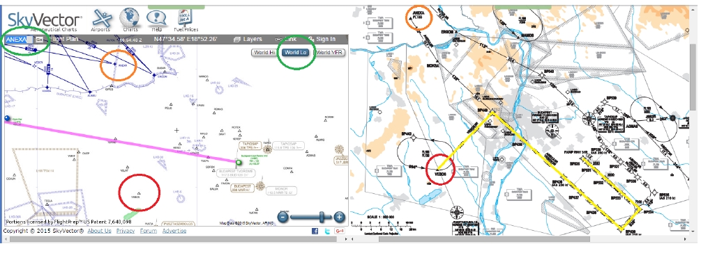
Two waypoints are interesting according to the flightpath: ANEXA and VEBOS. For training purposes, we decide to take VEBOS. Therefore, our STAR will be VEBOS3R Plot the arrival on SkyVector. If the waypoints are not displayed, enter them on the top left field or change map background (World Lo). You can also plot the path by dragging the flightpath to the target waypoint
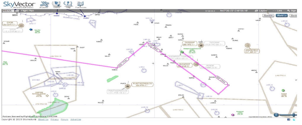
¶ Step 4 -- Enroute plotting
We are now going to connect these two waypoints (LANVI and VEBOS) in order to create the route.
Since our aircraft is capable to fly high and fast, we will use Upper Airways. Set SkyVector map background to World High.
We are starting at the first point LANVI. The best way to efficiently plot our route is to drag the flightpath on the selected waypoint.
Some airways have an arrow plot on the line: it means that the direction is not free and the airways should be flown only in this direction. Do not use these airways in opposite direction.
For example, for the first waypoint after LANVI, I drag the flightpath (clicking left mouse button) onto the EPL VOR. SkyVector will ask which waypoint to attach:
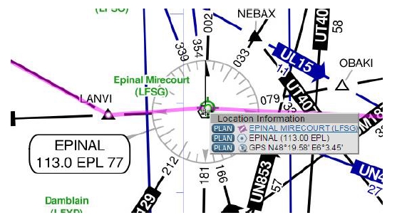
Select EPINAL VOR (113.00 EPL). Note that your flightplan is updated and displays the airway used (UM164):
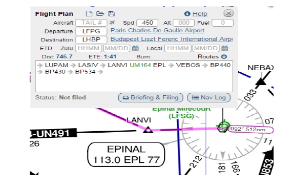
Repeat the drag-and-select method until you have reached the border of the Hungary FIR:
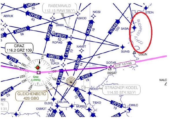
You should now see this plotting:
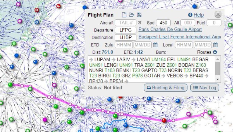
We obtain the following flightplan till the Hungarian border:
LANVI UM164 EPL UN491 TRA Z601 BODAN Z163 NUNRI T103 BEMKI T23 GRZ P978 GOTAR
Note that every time an airway is repeated, you can skip to the next waypoint. For example: BEMKI T23 GAPTO T23 NORIN T23 BERAS T23 BIRGI T23 GRZ becomes BEMKI T23 GRZ
As for the Hungarian part, Hungary has chosen to become a Free Route Airspace. You will not find any airways in the Hungarian airspace.
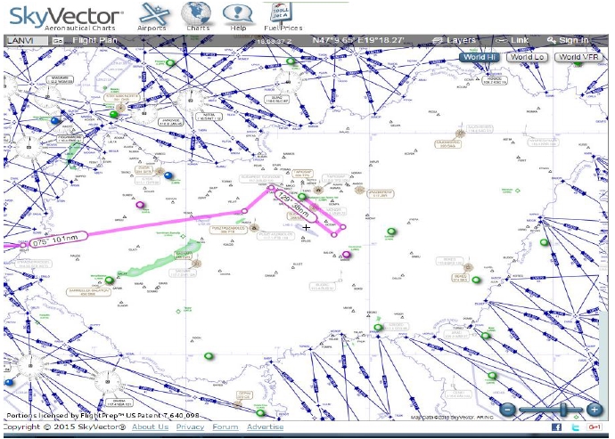
The solution is to make a direct from the last point at the Hungarian border to the first point of the arrival route. It is represented by an arrow in SkyVector flightplan, and marked DCT in a flightplan.
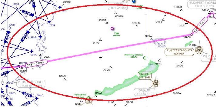
Our final routing is: LANVI UM164 EPL UN491 TRA Z601 BODAN Z163 NUNRI T103 BEMKI T23 GRZ P978 GOTAR DCT VEBOS
In Europe, SID and STAR designators (such as VEBOS3R) shall not appear in the flightplan.
¶ Vertical Flightpath Management
¶ Semi-circular rule
You must select a correct flight level in order to fly your route.
Remember the semi-circular rule: - Flying Westbound (180°-359°) gives an even flight level. - Flying Eastbound (000°-179°) gives an odd flight level.
Note that connecting from an airway to another will require some time to change your flight level. It will be written in the flightplan: WPT/NxxxxFxxx
¶ Regulatory flight levels
Since we have chosen to fly in upper airways, it is required to fly above FL195. European airspace is RVSM above FL285.
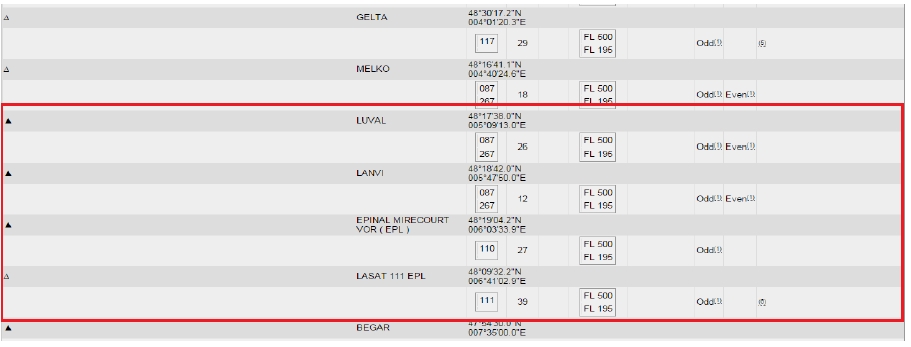
These airways have their own rules: Each route is described in the AIP of the country, AIP Part 2 -- ENR Part 3.
This description will give the waypoint included along the route, the parity of the flight levels to be flown, the vertical extent of the airway, etc...
For example, for UN491:
¶ Validation of the route (only for European routes)
¶ Initial validation
This step is not mandatory to fly on IVAO for a daily flight. But if you want to perform a real route "as real as it gets" or you want to have a valid route for your pilot exam, it is more than recommended to continue this tutorial.
As we are flying in Europe, all IFR flights must pass the CFMU validation process. This process ensures that the intended route is in accordance with the various European regulations (altitude restrictions, route reserved for specific origin/destination ...)
Please visit the official NOP Network Operations Portal > Tactical tab > Flight Planning section > Structured Editors to perform validation requests: https://www.public.nm.eurocontrol.int/PUBPORTAL/gateway/spec/
Two choices are available: "Free Editor" and "Structured Editor".
I recommend you to use the Structured Editor. File the fields as if you were filing your flightplan.
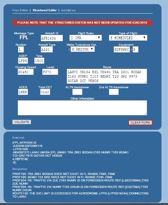
After validating, the system should return all the problems found:

¶ Correction of errors
Let's take these errors one by one:
PROF195: TRA Z601 BODAN DOES NOT EXIST IN FL RANGE F095...F999.
We need to find another route or if we want to stay on this route, we will have to descent below FL095, which is not acceptable for us.
Go back to SkyVector. Center your map on TRA.
We can see that in fact Skyvector assigned automatically airway Z601. But the relevant airway we were targeting here is: UN491. We should then change to airway T103 at the ZURICH VOR (ZUE)
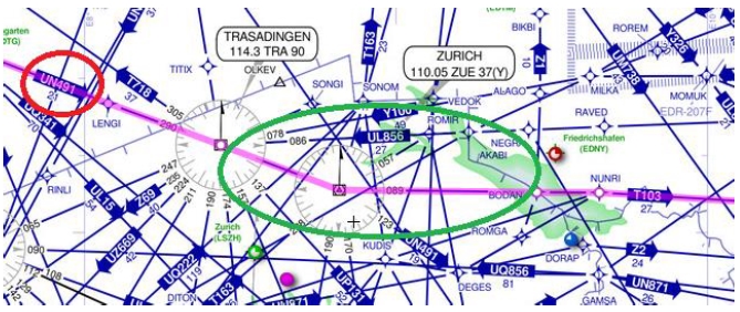
So the route is changed from: EPL UN491 TRA Z601 BODAN to EPL UN491 ZUE T103 BEMKI
PROF195: BEMKI T23 GRZ DOES NOT EXIST IN FL RANGE F245...F999.
It is another bad selection of airway. We were targeting UT23 all the way long. BEMKI T23 GRZ shall become BEMKI UT23 GRZ
PROF204: RS: TRAFFIC VIA ZUE Z163 NUNRI IS ON FORBIDDEN ROUTE REF:[LSED1009A] Z163 ZUE NUNRI
We are now going from ZUE to NUNRI via T103, so we can discard this error.
PROF204: RS: TRAFFIC VIA NUNRI T103 DISUN IS ON FORBIDDEN ROUTE REF:[ED2709A] T103 NUNRI DISUN
We use airway T103 on this section: NUNRI T103 BEMKI
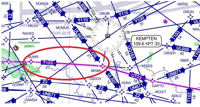
Since the restriction is not precise enough, a search in the German AIP for [ED2709A] gives us: "Only available for traffic arriving EDDM/MA/MO ETSA/SI/SL from NUNRI to DISUN"
Therefore, we need to fly along T103 before NUNRI.
Actually, we are now flying on airway T103 from ZUE, so this error is therefore solved.
Our corrected route is: LANVI UM164 EPL UN491 ZUE T103 BEMKI UT23 GRZ P978 GOTAR DCT VEBOS
ROUTE135: THE SID LIMIT IS EXCEEDED
Discard the last error. It will show up from time to time on several airports. Just check on the according SID chart that the departure is not restricted by "On ATC clearance only" conditions. It can also be restricted to local airlines, etc...
A common error is not found on this route and is about parity change for flight levels. If you happen to face such restriction, do not forget to add: WPT/NxxxxFxxx where N is the expected speed and F is the new flight level. Climb or descent should be initiated on or after passing the waypoint and not before, and is always subject to ATC clearance.
¶ Final validation
Now, we will submit the new route through the system and check if there are new errors.
If no error is returned by the system, then: Congratulations! Your route has passed all the various restrictions of the European airspace.
In the other case, it goes for another round of corrections. In our case, we still meet one error:
ROUTE139: T103 IS PRECEDED BY ZUE WHICH IS NOT ONE OF ITS POINTS
In that case, we need to reroute. Let's go back to SkyVector. It's now about finding a route not too far from the first one to avoid the conflicting area. What happens if we continue from ZUE to DEGES on UN491? We can then fly along UN871 till GAPTO, which is a waypoint of UT23 which is our initial route.

The new section of the route is UN491 DEGES UN871 GAPTO UT23.
Therefore, our new corrected route is: LANVI UM164 EPL UN491 DEGES UN871 GAPTO UT23 GRZ P978 GOTAR DCT VEBOS
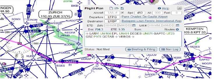
This last route is finally accepted by the system!
¶ Conclusion
Building an IFR route is not something particularly difficult if we take the time to do it correctly. With habit, it will become easier and easier to elaborate an initial route.
The tricky part will always be correcting the initial route to make it compliant with all the restrictions due to operating in the European airspaces. But at the end, it is extremely rewarding if you can fly "as real as it gets"
In addition to this tutorial, you can also try go further by:
- Optimizing your route (our final route is 704NM, giving an increase of 4% in distance compared to the shortest route possible).
- Elaborate your route taking into account bad weather conditions
- Flying other airspace regulations and restrictions (North Atlantic Tracks, etc...)
- None
- None
- VID 200696 - Creation
- VID 150259 - Update
- VID 531824 - Wiki Integration
- VID 496402 - Wiki.js integration