¶ Introduction
This document will introduce you to IFR route planning methods.
Given the amount of daily flights taking place above our heads, we need these aircraft to fly orderly. That's why they follow predefined routes named airways, connected by fixes or radio navigation aids.
Through the reading of these pages, we are going to learn many things about route planning. We will review a few regulations, including some specific airspaces, before moving onto the heart of the subject with learning how to build a route, using both simple and sophisticated tools to match it with the several restrictions that happen to exist.
However, here are some points that will not be dealt with. First, we will only use free tools in order to make this document accessible to anyone and because we do not want to advertise commercial software. In addition to this, we are only interested in route planning, which means, that we are neither going to deal with fuel planning and management, nor with flight plan specifications. Take a look at our full documentation to learn about these subjects.
¶ General Concepts
¶ Navigation Basics
Flying an aircraft is often a way to go from an origin A to a destination B. As the earth is a sphere, there are many different ways to fly between these points.
In navigation, you learnt that you can fly either along a loxodromy, or an orthodromy.
- Loxodromy: A course-constant route between 2 points on earth.
- Orthodromy: A great circle route between 2 points on earth. This one is always the shortest.
Therefore, over 200NM, an orthodromic route should always be preferred.
Below, you can see the differences for a route between Paris and Mexico City.
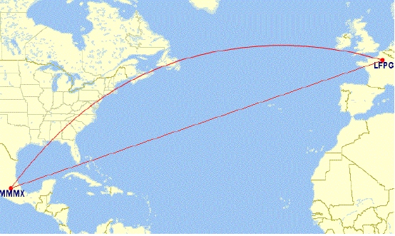
- The upper line like a circle arc is the orthodromy.
- The lower line is course-constant and is the loxodromy.
¶ Airways
While you will be flying in airspace, you will need to fly in compliance with many regulations, in regard to other traffic, and relying on navigation points. In order to keep an orderly flow and to minimize the risk of collision, it was decided to create airways.
An airway is a volume in which an airplane is protected in regard to terrain collision and availability of its navigation means. Due to the fact that several airways may intersect, it cannot be protected for collisions. It is still up to both the pilots and the ATCs to monitor the traffic.
The volume dimension of an airway is defined by each national AIP. An airway is often created between two navigation points (VOR, NDB, DME, intersections...) between which traffic flow is substantial.
Given the number of flights that may be very large along a single airway, an airway is a controlled area depending on your type of flight.
The identifier consists of one or two letters and one or several digits (V40,UN635) The letter in the identifier of an airway is meant to indicate its type (RNAV-ability, part of regional network, provided ATS, RNP, minimum altitude...).
Each country will then publish a list including all navigation fixes included along each airway.
The minimal en-route altitude, the parity and direction are sometimes mentioned when needed.
¶ Off-airway Directs
In some cases, it is not possible to fly along an airway.
There may be various reasons for that but the most common are:
- Airspace does not have any airways
- Weather & Wind
- Too many restrictions/constraints
- Poor airway interconnection
Regulation permits you flying between two points directly. This is called a direct and will be written down DCT in a flight plan. However, some airspaces do not allow to fly directs. In some airspaces, directs are also subject to particular regulations (maximum distance, maximum flight time...).
Depending on the circumstances, you can request and obtain an in-flight direct from the controller.
¶ Departures and arrivals: SID/STAR
National flight regulation offices have built Standard Instrument Departures (SID) and Standard Terminal Arrival Routes (STAR) for the major IFR airfields. They are procedures designed in order to regulate the flow of inbound and outbound traffic around an airport by connecting it to the network of airways.
Some airports do not have these kinds of procedures. Regulation permits aircraft to join their first en-route point directly as omnidirectional departure or to join the Initial Approach Fix (IAF) directly as omnidirectional arrival.
The first point of your flight plan route will be usually the last point of a selected standard departure procedure. Reciprocally, the last point of your route is likely to be the first point of the selected standard arrival procedure.
It is important to choose the correct SID and STAR according to the direction you are flying to/from. You must be very careful also to the requirements and constraints of a procedure (RNAV capability, maximum category of airplane, minimum climbing rate...).
¶ Vertical Management
Along with flying a correct route, you must also fly at the correct altitudes.
Some airspaces have dedicated regulations and some will apply specific parity to an airway.
Pay attention that connecting from an airway to another will require some time to change your flight level.
You must select flight level and altitude according your flight rules and semi-circular rule:
- Follow the Series of FL stated on AIP publications, by charts and ATS Routes information / (recommendation seems a bit light)
- Use the local semi-circular rule (if AIP is not available for public or AIP does not state specific use) / (local semi-circular is a better choice, to prevent cases of where the E/W semi is not used)
Chart links can be consulted on IVAO here.
¶ Specific Regulations
¶ ETOPS Flights
ETOPS stands for Extended-range Twin-engine Operation Performance Standards. Caution: ETOPS is not an airspace!
Practically, regulations require for a twin-engine air transport aircraft to fly not further than 60 minutes to an airport considering the flight time for single engine operations. It is however possible for an operator to obtain an accreditation from its State Authority to operate outside this 60-minute restriction. This accreditation must be obtained for each aircraft.
Flight planning should take into consideration this parameter.
An aircraft is specifically approved for a specific time under ETOPS regulations. The method is to draw circles around ETOPS en-route alternate airports along the flightpath. As long as the aircraft remains in at least one of these time-constant circles, the flight can be performed.
For the flight to be continued while flying, the chosen airports must be available in regard to operations and weather. If an airport becomes unavailable, another suitable airport should be elected.
¶ MNPS Airspaces
MNPS stands for Minimum Navigation Performance Specification and is a particular specifity of the North Atlantic Airspaces:
- Shanwick Radio
- Gander Radio
- New York Radio
- Santa Maria Radio
The regulations allow a lateral separation as little as 50.5NM, up to 60NM, for aircraft operating between FL285 and FL420.
It enables also a longitudinal separation of 15 minutes.
Given the amount of flights flying over the Atlantic, daily tracks have been implemented called NATS. These tracks are set up corresponding to the weather and the wind aloft. Aircraft should preferably choose to fly these published routes.
Daily publications can be found here.
¶ Free Route Airspaces
Some airspaces have chosen not to create airways.
Some good examples are Hungary, Ireland and Portugal.
For in-transit flights, a direct-to across the airspace is given. For inbound flights within an airport of the airspace, an appropriate direct-to from the entry to the beginning of the IFR procedure (STAR/Approach) or to the airfield for VFR flights will be given.
For outbound flights within an airport of the airspace, an appropriate direct-to from the airfield or from the end of the IFR procedure to the exit waypoint will be given.
¶ Route Creation
¶ SkyVector
SkyVector.com is a website that allows you to display worldwide aeronautical en-route charts. It is particularly useful as it displays both VFR and IFR en-route charts, at both lower and upper levels.
On the top right corner of the map, you can decide which charts you want to use. On the top left corner of the map, you can look for specific navigation waypoints (VOR, NDB, Waypoint...). You can also enter a flight plan and obtain a complete nav log.
The map will let you pick the airways or the flightpath you want to fly along. You can also obtain the bearing and the distance of a waypoint related to another, which can be helpful for VFR navigation.
This website will not find you a route.
You must build it manually. It is the best way to learn how to build a route, and understand the restrictions related to its usage.
¶ Route Finder
Route Finder is a website that allows you to create a route from an airport to another between two cruise flight levels you will choose. It gives you all the useful information you need: route, distances, track and times amongst others. It will also try to decide which SID and STAR fit the best for your route and will try to find North Atlantic Tracks if necessary.
To use it, simply fill the form on the top of the page.
The result page will display you the full navigation log.

Pay attention that you must select the type of layer that you want:
- High corresponds to the upper airspace (FL>FL200 to FL265 in function of airspace)
- Low corresponds to the lower airspace for low altitude flights (short IFR flights or low performance aircraft)
¶ IVAO Route Database
The IVAO Route Database is a member-only database built, reviewed and updated by the IVAO Flight Operations Department. Routes are submitted and comply with the regulations of the various overflown airspaces.
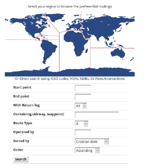
Simply fill the form to find your route.
If several routes exist, the system will show them all.
Requests can be made on the IVAO Forum to obtain specific routes.
Since every route cannot be checked when there is an update of the navigation database (every 28 days), routes should be carefully reviewed and must be checked to be in accordance with the latest navigation data.
¶ Edi-gla.co.uk
Edi-gla.co.uk is an independent website where users can obtain real world flight plans. Only real routes can be requested.
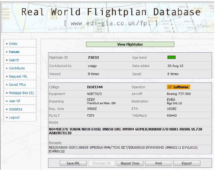
Simply register/log on the website. Then you will be able to search through the numerous amounts of flight plans. Flight plans are sorted by date, the most recent comes first. You will be eligible to file your own request after a 30-day period.
Since routes are submitted without future review, the navigation database may have changed when you will select it. It is your responsibility to check that the route complies with all the current navigation data and regulations.
¶ FlightAware
FlightAware is an aviation-related website where users can check for flight status. In addition to typical flight information being displayed, it also displays the assumed route of the flight.
Simply enter your flight number and the airline (Only real flights are accepted). If you want to see a route, you can also enter the departure and the arrival ICAO codes and it will display all the known flights between those two airports.

Assumed routes can be erroneous and it is vital to double check it before filing it in your flight plan. Also, for some flights, the given route is only for some parts of the flight (typically, only over the US for transatlantic European flights).
¶ EuroFPL
EuroFPL is a website dedicated to real flight planning. In our case it is also appropriate as it permits to gather a lot of data in very short time: NOTAM, weather, catalog of routes, charts, flight tracking, navigation log...
It is required to create an account in order to access the website.
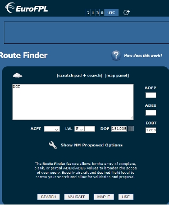
Select "Route Finder" and you will be able to build a route from scratch.
In the system you must create a fictive aircraft before searching your flight plan.
This tool can also manage a fleet of aircraft in order to make the validation of your routes easier.
Caution: do not file a flight plan form! It's only for REAL use.
This tool will only compute European routes.
¶ Route Validation: Eurocontrol Route Editor
When flying over the European airspaces, a tool has been developed to certify that the requested route is in conformity with all the restrictions along it. This tool is the Eurocontrol Route Editor.
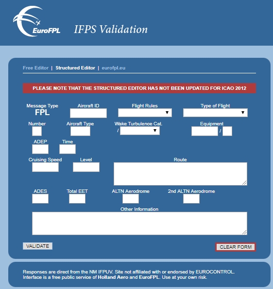
You have two ways to use this tool:
- Free(-text) editor: you should file the flight plan according to the OACI ATFN Standards.
- Structured text editor: the form is representing an actual flight plan and it allows you to fill the fields more easily.
Once you have entered your flight plan, the system will check it and will generate errors regarding:
- Restricted airspaces
- Wrong flight level
- Inadequate airways
You route is valid and in conformity only when you have corrected all the errors.
For this, you can use DCT (Direct) and WPT/NXXXXFXXX syntax as the system will understand it. This tool will validate only the European part of your flight.
¶ Conclusion
Route planning should be taken care of very carefully before every flight.
Nowadays, we have numerous tools to help us build a route, matching reality, and in accordance with world-wide regulations.
Then you have no excuse to have a wrong route now!
However, route planning shall not be performed alone and shall be built in regard to:
- Fuel Planning
- Weather forecasting
- Aircraft performances
- none
- none
- VID 200696 - Creation
- VID 531824 - Wiki integration
- VID 496402 - Wiki.js integration