¶ Introduction
In most of modern aircraft, the couple PFD and ND is present. The Navigation display screen displays the lateral navigation status of the aircraft.
The latest navigation displays are also able to display the vertical flight profile.
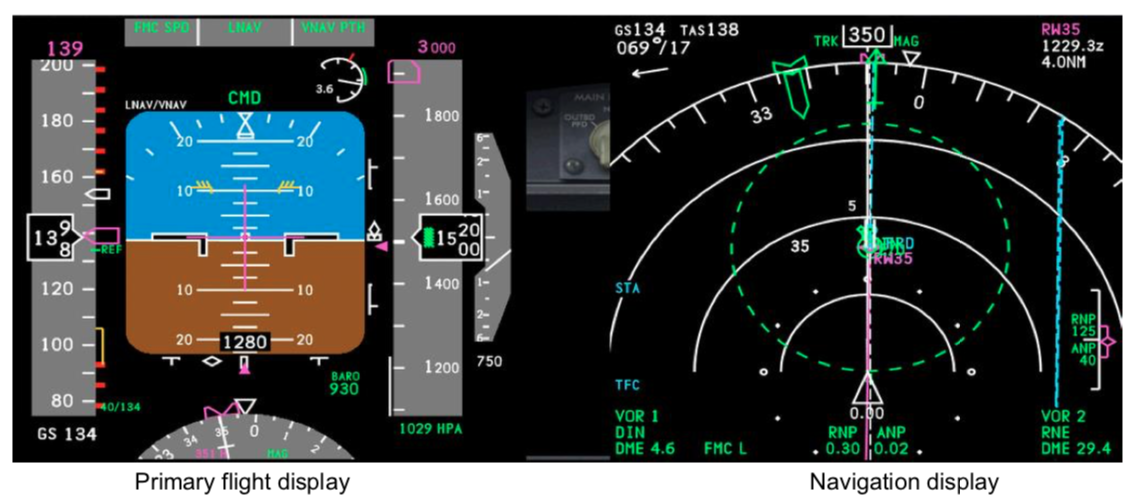
NDs are the evolutions of the EHSI (Electronic Horizontal Situation Indicator) and implemented for the first time in the 90's on A320 and B737 aircraft.
The main characteristic of the Navigation Display is the colour screen and the ability to display different modes and functions : route flown, VOR, AFD, ILS, Weather Radar, TCAS, etc.
¶ EFIS Control Panel - ECP
A rotating button to switch between different ND modes is present in the aircraft cockpit on the EFIS Control Panel.
Often located on the glare shield, each pilot has his own ECP to control his Navigation Display.
Additional controls like the brightness or the terrain/weather radar may not be located on the ECP but on a dedicated panel.
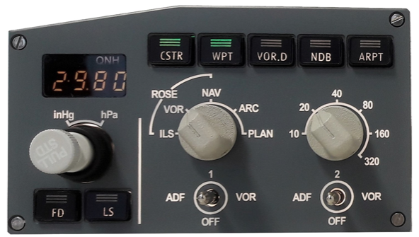
Airbus A320 ECP
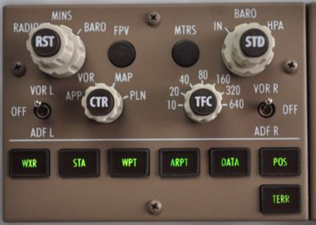
Boeing B777 ECP
In case of an ECP failure, back-up exists : both NDs can be controlled by the remaining functional ECP, or via the FMS.
¶ ND Modes
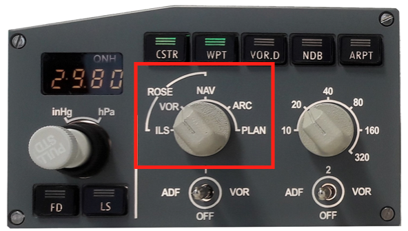
We will take for example the 5 ND modes of the A320:
- ILS
- VOR
- NAV
- ARC
- PLAN
Switching between the 5 modes can be done through the mode selector on the ECP (red square).
¶ ILS Mode
While using this mode, the ND is acting like a HSI:
- The aircraft is centred (yellow symbol)
- Current heading up
- Ground Speed, TAS and wind are located in the top left corner
- ILS frequency, course and identification are located in the top right corner
- If the ILS is engaged on the FMGS (Flight Management and Guidance System), "ILS APP" will be displayed in green at the top middle
- Localizer and Glide slope deviation will be displayed in magenta

In this example, the aircraft is flying on heading 130 to establish on the IDGQ (111.7 / course 003) ILS. The Glide Slope diamond is empty and below the outer circle, the aircraft is well above the IDQG Glide Slope.
¶ VOR Mode
While using this mode, the ND is acting like a HSI.
- The aircraft is centred (yellow symbol)
- Current heading up
- Ground Speed, TAS and wind are located in the top left corner
- VOR frequency, course and identification are located in the top right corner
- If the VOR is entered on the FMGS, "VOR APP" will be displayed in green at the top middle
- VOR radial deviation will be displayed in blue, the arrow will point toward the VOR (FROM/TO function)
- If activated on the ECP, bearings will point toward the VOR1 and/or VOR2 stations and identifications will be displayed on the ND screen bottom. DME is also indicating the distance to the stations.
In this example, the aircraft is flying on heading 130 to join radial 093 inbound CLT (115.0) VOR. Bearings 1 and 2 are activated and both pointing to CLT. The aircraft is 26NM from CLT.
¶ NAV Mode
While using this mode, the ND is showing the current route flown with the aircraft centred.
This mode may be used when flying a departure/arrival procedure that is doing a 180° to have a global view.

- The aircraft is centred (yellow symbol)
- Current heading up
- Ground Speed, TAS and wind are located in the top left corner
- Next waypoint, course to join, distance and Estimated Time of Arrival (ETA) are located in the top right corner
- If the type of approach is entered on the FMGS, "VOR APP", "ILS APP", or "RNAV APP" will be displayed in green at the top middle
- The route is displayed in green
- Next waypoint is in white
- Other waypoints on the route are in green (already flown or after the next waypoint)
In this example, the aircraft is flying on heading 130, has just passed "FOSSE", next waypoint is CEDOX, course to CEDOX is 135°, distance is 16.8NM and ETA is 13:10z. We can also see 12NM ahead of the current position the FMGS calculated END of descend (blue arrow).
¶ ARC Mode
The ARC mode is the most used mode during a standard flight.
- The aircraft is at the bottom of the screen (yellow symbol)
- Current heading up
- Ground Speed, TAS, and wind are located in the top left corner
- Next waypoint, course to join, distance and Estimated Time of Arrival (ETA) are located in the top right corner
- If the type of approach is entered on the FMGS, "VOR APP", "ILS APP" or "RNAV APP" will be displayed in green at the top middle
- The route is displayed in green
- Waypoints flown are in green
- Next waypoints are in white
- If activated on the ECP, bearings will point toward the VOR1 and/or VOR2 stations and identifications will be displayed on the ND screen bottom. DME is also indicating the distance to the stations.
In this example, the aircraft is flying on heading 130, has just passed "FOSSE", next waypoint is CEDOX, course to CEDOX is 135°, distance is 16.8NM and ETA is 13:10z. The CLT VOR is in front of us (arrows aligned with current heading) and 26NM ahead (DME located at the bottom). We can also see 12NM ahead of the current position the FMGS calculated END of descend (blue arrow).
In ARC mode the pilot may display more information through the ECP like nearest airports, VOR, NDB, etc.
¶ PLAN Mode
The PLAN mode is used to display the route entered in the FMGS and check this route before flying it.
http://www.a320dp.com/A320_DP/flight-instruments/images/ndplanmode.jpg
- The screen is centred on the waypoint selected in the FMGS
- The aircraft with it's yellow symbol if located on the displayed portion !
- True North Up
- Ground Speed, TAS and wind are located in the top left corner
- Next waypoint, course to join, distance and Estimated Time of Arrival (ETA) are located in the top right corner
- If the type of approach is entered on the FMGS, "VOR APP", "ILS APP" or "RNAV APP" will be displayed in green on the top middle
- Active route is displayed in green
- Non-active routes are displayed in blue or yellow (offset, missed approached procedure for example)
- Waypoints flown will be in green
- Next waypoints will be in white
In this example, the aircraft is flying on heading 130, has just passed "FOSSE", next waypoint is CEDOX, course to CEDOX is 135°, distance is 16.8NM and ETA is 13:10z. Next waypoints will be DOOSE, then IKICO. The final approach for KCTL ILS 36L is NIVSE, then GLASI.
¶ ND range & filters
¶ Range
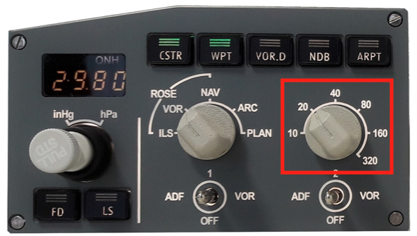
On most of the ND is the possibility to choose the range.
The range is expressed in NM (nautical miles).
The range limits are aircraft dependent. Example : A320 goes from 10 NM to 320 NM, B737 goes from 5 to 640 NM, depending on the configuration.
The range can be selected on the ECP, see red square bellow.
¶ Filters
As for the ND modes, we'll take the A320 example. Each aircraft has its own options, the A320 has the standard ones. Additional features will be discussed later in this article.
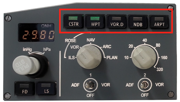
¶ CSTR : Constraint
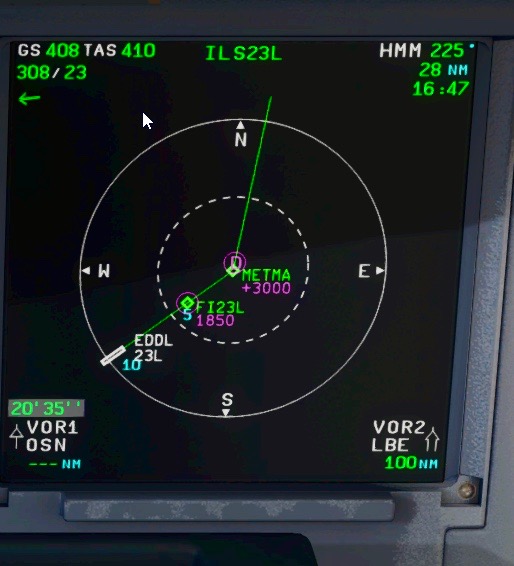
On this picture, we are preparing our arrival to EDDL on runway 23L. We are in PLAN mode, and CSTR activated. In magenta you can see the constraints are displayed. In this example, METMA has to be flown at 3000ft or above (+3000), FI32L has to be flown at 1850ft.
These constraints are entered through the FMGS, it can be speeds or altitudes.
¶ WPT : Waypoint
When activated, displays all waypoints on the navigation display .
When using the waypoints display function with a high range, it may overload the SGU (Symbol Generator Unit) giving an error message.
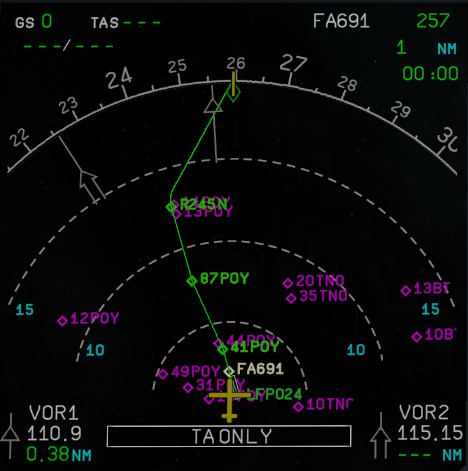
In this example, waypoints are empty magenta diamonds.
¶ VOR.D : VOR DME
When activated, displays all VOR/DME on the navigation display .
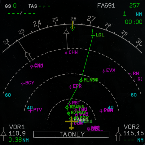
In this example, VOR are magenta crosses (ex : PTV) and VOR DME are magenta crosses with an empty circle in the middle (ex : BCY).
¶ NDB : NDB
When activated, displays all NDB on the navigation display .
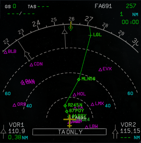
In this example, NDB are magenta triangles.
¶ ARPT : Airports
When activated, displays all airports on the navigation display .
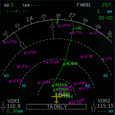
In this example, airports are magenta asterisks.
Airports displayed are the ones included in the FMGS database. Depending on the aircraft owner, it can include all airports, or only airports where the aircraft has the performances to take off and land.
¶ Additional information
Additional information may be displayed on the Navigation Display, via
the ECP or other switches depending on the aircraft configuration.
¶ TCAS Display
TCAS information can be displayed on the navigation display via a switch located on the transponder (on pedestal panel for A320).
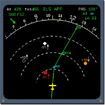
For more information about the TCAS system, read Traffic collision avoidance system - TCAS
¶ Terrain radar

B737 Navigation Display in ARC mode with terrain radar activated.
Radar terrain information can be displayed on the navigation
display via a switch located next to the ND. A special colour scheme
enables the pilot to know the terrain clearance.
¶ Weather Radar display
Weather radar information can be displayed on the navigation display via a switch located on the weather radar control panel (usually on the pedestal).
The weather radar reflects the concentration of liquid in the air. Green
means few liquid water, Red indicates an important concentration of
liquid water (i.e. very active CB/TCU cloud with a large amount of
supercooled water, dangerous due to the aircraft icing risk).
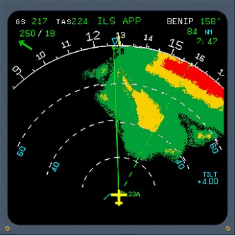
A320 Navigation Display in ARC mode with weather radar activated
For more information about the Weather radar, read Good use of weather radar!
¶ Vertical Flight Profile display
On the most recent aircraft, the vertical flight profile is displayed at
the bottom of the Navigation Display.

A380 PFD & ND
In this example, we can see this A380 is in steady cruise at FL400,
the terrain is below FL100, and the MORA is 8800 ft.
¶ Other information
As for the vertical flight profile, on some recent aircraft, the ND
screen can be used for other functions, like ground charts while on the
ground, or camera display.
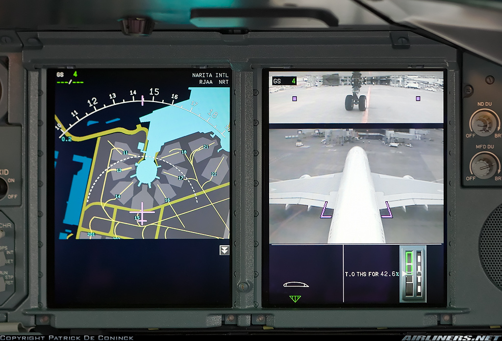
A380 ND & PFD on ground
- None
- None
- VID 450012 - Creation
- VID 497664 & 496402 - Wiki.js Integration.