¶ RNP Operations
¶ 1. Introduction
Planes were made as a means of transport. To successfully fly from a location A to a location B, pilots were
first and foremost navigators.
Originally relying on visual landmarks such as cities, rivers, terrain or roads, they then used to navigate using newer technologies based on radio systems such as NDB and VOR. Nowadays, the GPS is the latest and best system to fly around the world with accuracy and reliability. However, depending on their locations, planes may have difficulties to acquire and exploit satellite signals.
ICAO has designed standards related to reliability, accuracy and performance of GPS systems for navigation. In regard to these standards, Performance Based Navigation (PBN) was created in order to ensure Required Navigation Performance during all phases of a flight, from enroute, to approach.
This document is for advanced/authorized users only. It refers to concepts that should be clearly understood before going deeper into today’s most advanced navigation techniques.
¶ 2. Navigation capability
¶ 2.1 Key concepts
We will now explain the key concepts that should not be mixed up and that are commonly not precisely understood.
¶ 2.1.1 Performance Based Navigation (PBN)
Performance Based Navigation was introduced to standardize Area Navigation (RNAV) system specifications and ensure performance accuracy along an airway, in an approach procedure or a specific airspace.
This performance accuracy also refers to Required Navigation Performance (RNP) operations and is the most sophisticated navigation means
PBN will allow using with more efficiency the RNAV and RNP systems leading to optimized airspace in terms of fuel efficient and noise reduced routes and procedures. In addition, as it is based on these systems, it allows aircraft changing from sensor-based navigation, to performance-based navigation.
As long as you can maintain a satellite signal considered strong enough by ICAO, it is not needed anymoreto rely on a conventional sensor (i.e. radio aids)
¶ 2.1.2 Area Navigation (RNAV)
Area Navigation is a method of navigation relying on computation of the aircraft position through sensors (satellite signal, VOR radials and DME measures) in order to fly a designated lateral and vertical flightpath. It is therefore a type of Performance Based Navigation
When a procedure is said to be RNAV, it means that if the aircraft position is computed with enough precision, the flightpath will be flyable without necessarily relying on ground sensors such as radio aids.In fact, a simple satellite signal (by means of GPS) will allow flying through non-physical waypoints (i.e. only plotted with coordinates, and not by two VOR radials for example). Finally, most complete procedures will make flying these waypoints at, below or above an altitude, a complete 3D flightpath.
RNAV is the future of navigation, and should completely replace sensor-based procedures and routes.
¶ 2.1.3 Required Navigation Performance (RNP)
Required Navigation Performance is also a type of Performance Based Navigation. It is very similar to the RNAV concept, except that it enhances it using on-board navigation performance monitoring and alerting
It is the key difference with RNAV. It allows reducing procedures margins at the benefit of optimized flightpaths. However, the required performance is strongly increased, up to the tenth of a nautical mile. This requirement will be adapted to the phase of the flight.
One more point in using RNP is the ability to fly Radius-To-Fix (RF) segments.
¶ 2.2. Phase of flight
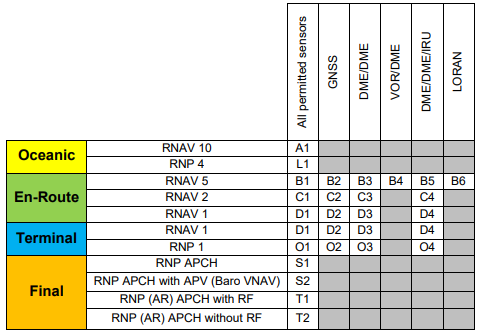
Actual PBN specifications and their usage. RNP 2 and below, A-RNP and RNP (AR) APCH are terminal and
approach-oriented.
¶ 2.1.1. En-Route (ENR)
We distinguish three different PBN en-route applications:
RNAV 5 (Basic RNAV ~ B-RNAV)
RNAV 1 (Precision RNAV ~ P-RNAV)
Advanced RNP ~ A-RNP
¶ 2.2.2. Terminal (TMA)
We distinguish four different PBN terminal applications:
RNAV 1 (P-RNAV)
Basic RNP 1
Advanced RNP RNP
Authorisation Required ~ RNP-AR
¶ 2.2.3. Approach (APCH)
We distinguish four different approach applications:
RNP APCH – Non Precision Approach (NPA) with 2D Path Guidance
RNP APCH – Approach with Vertical Guidance (APV) ~ 3D Path Guidance
A-RNP
RNP-AR
¶ 2.3. Required Accuracy
RNAV ‘x’ / RNP ‘x’ mean that in terms of reliability, the aircraft should be able to fly 95% of the flight time with accuracy within a radius of ‘x’ miles around the centerline of the desired flightpath.
In addition, RNP operations will allow monitoring of the performance and alerting in case of loss of accuracy. Monitoring of the performance by the crew is mandatory (ANP versus RNP) Given this system, RNP operations allow flying 99% of the flight time within a radius of 2*x miles around thecenterline of the desired flightpath.
In regard to the different types of RNP, RNP APCH and RNP (AR) APCH are the most demanding PBN since they are equivalent to RNP 0.3
To achieve this, the aircraft will rely on various sensors and the operators are required to file in their flightplan the PBN ability of their aircraft:

¶ 3. RNP Operations
¶ 3.1. Basic RNP (RNP 1)
Basic RNP, or RNP 1, is used as part of the RNP Terminal Applications.
It concerns SID/STAR and Initial Approach operations.
In mountainous regions, it allows more optimized flight paths than RNAV operations.
RNP 1 also includes Radius-To-Fix (RF) operations in addition to RNAV operations.
Be careful: some SID/STAR requires a higher accuracy at the beginning or at the end of the procedure than
Basic RNP.
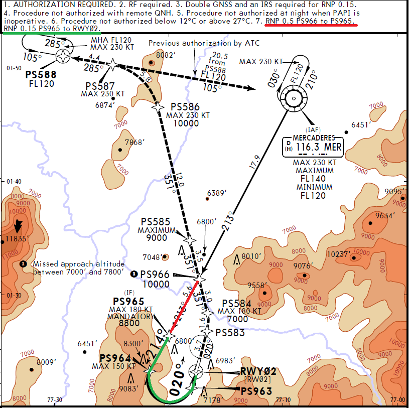
Lets take a look at the following chart:
Note there are different RNP Specifications for different segments of the procedure
¶ Examples
RNP 0.5 Marked on RED
RNP 0.15 Marked on GREEN

Note that RF is required
¶ 3.2. Advanced RNP (A-RNP)
A-RNP is part of the next improvement to be implemented to the current navigation standards.
It will be dedicated to En-Route operations and will enhance current RNAV operations.
Benefits will include:
-Optimized Lateral Navigation: closer routes, constant spacing requirements even on turning
segments, reduced holding area, and contingency offset routes to avoid radar vectoring.
-Optimized Vertical Navigation: cleaner separation of arrival and departure flows, effective use of
Continuous Descent/Climb Operations (CDO/CCO).
-Optimized Longitudinal Navigation: Management of entry/exit time between Terminal Area and
Enroute Area
The only existing RNP Operations dedicated to En-Route is RNP 4 above oceanic and remote continental
airspaces.
¶ 3.3. RNP Approach (RNP APCH)
¶ 3.1.1. Generalities
RNP APCH operations extend from the beginning of an initial approach segment to the end of a missed
approach segment.
Where it requires RNP 1 for all other segments, the required accuracy is increased to 0.3NM on the final
segment.
These approaches are created for the following reasons:
- Non-existent instrument procedures
- Replacement for old generation instrument procedures
- Enhancement of existing procedures in terms of environmental concerns (noise, terrain, …)
Like RNP terminal operations, RNP APCH operations allow the use of Radius-To-Fix (RF) segments.
Minima are comparable to existing conventional approaches along with the type of guidance (2D, 3D Baro
VNAV, 3D PA).
Caution: RNP Operations based on Baro-VNAV Vertical Guidance are only flyable for temperatures above
a minimum temperature specified on the chart of the procedure.
¶ 3.2.2. Authorization Required APCH (AR APCH)
RNP AR APCH operations are approaches that require a special approval authorization for the air crew, the
operator and the aircraft.
This restriction allows demanding another level of accuracy, as low as 0.1NM
Along the final segment and initial segment of a missed approach:
- RNP0.1 and RF segments
- Other segments : RNP0.3


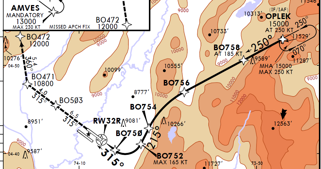
From this chart we can extract the following information:
- Authorization required
- Minimum temperature -5º
- RF required
¶ 4. Conclusion
RNP operations are another shift in the way aircraft are operated.
Today’s navigation is more and more focused toward optimization of flightpaths while ensuring safety.
This shall lead to an environment-friendly aviation, taking into account sensitive areas in regard to terrain
and noise as decisive factors.
While flightpaths are more and more precise, from 2D projections to 4D projections, requirements are more
and more demanding in terms of equipment and reliability
- None
- None
- VID 412728 - Creation
- VID 514786, TDM - Wiki.js integration and approval