¶ Introduction
A SIGMET (Significant Meteorological Information) is a meteorological report issued by a meteorological watch office that gives a description in abbreviated plain language of the occurrence and/or expected occurrence of specified en-route weather phenomena, which may affect the safety of aircraft operations and the development of those phenomena in time and space.
They are issued with a maximum duration of 4 hours (if the message is for Volcanic Ash cloud and/or Tropical Cyclones, the max duration is 6 hours) and shall be cancelled by another message when the phenomenon is not observed anymore or has changed significantly.
Usually, SIGMETs are issued for observations/forecasts occurring above FL100, while the information below that level is covered by AIRMETs (Airmen's Meteorological Information).
¶ Types of SIGMET
Per ICAO definition, there are three types of SIGMET:
- SIGMET for Volcanic Ash (VA SIGMET or WV SIGMET);
- SIGMET for Tropical Cyclone (TC SIGMET);
- SIGMET for any other en-route weather phenomena except Volcanic Ash and Tropical Cyclone
(which may be Thunderstorms [TS], Turbulence [TURB], Icing [ICE], Mountain Waves [MTW], Dust Storm [DS], Sand Storm [SS] or Radioactive Cloud [RDOACT CLD]) (WS SIGMET).
The type of the message is identified in its header.
¶ Structure of a SIGMET
Let's use this SIGMET as an example:
WSBZ21 SBRE 150430
SBAO SIGMET 1 VALID 150435/150835 SBRE-
SBAO ATLANTIC FIR EMBD TS FCST AT 0435Z WI S3154 W04804 - S3400 W05000 -
S3400 W04625 - S3154 W04804 TOP FL380 MOV NE 05KT NC=
¶ Header
The header of the SIGMET message contains the type of the message, issuing country or territory, bulletin number, creator of the message (generally the FIR where the observation/forecast is in) and the date/time of the dissemination of the message.
In our example:
-
WSBZ21
- WS indicates that the message is a SIGMET for any en-route phenomena. In case of a SIGMET for Volcanic Ash, it shall be WV and for a SIGMET for Tropical Cyclone, WC.
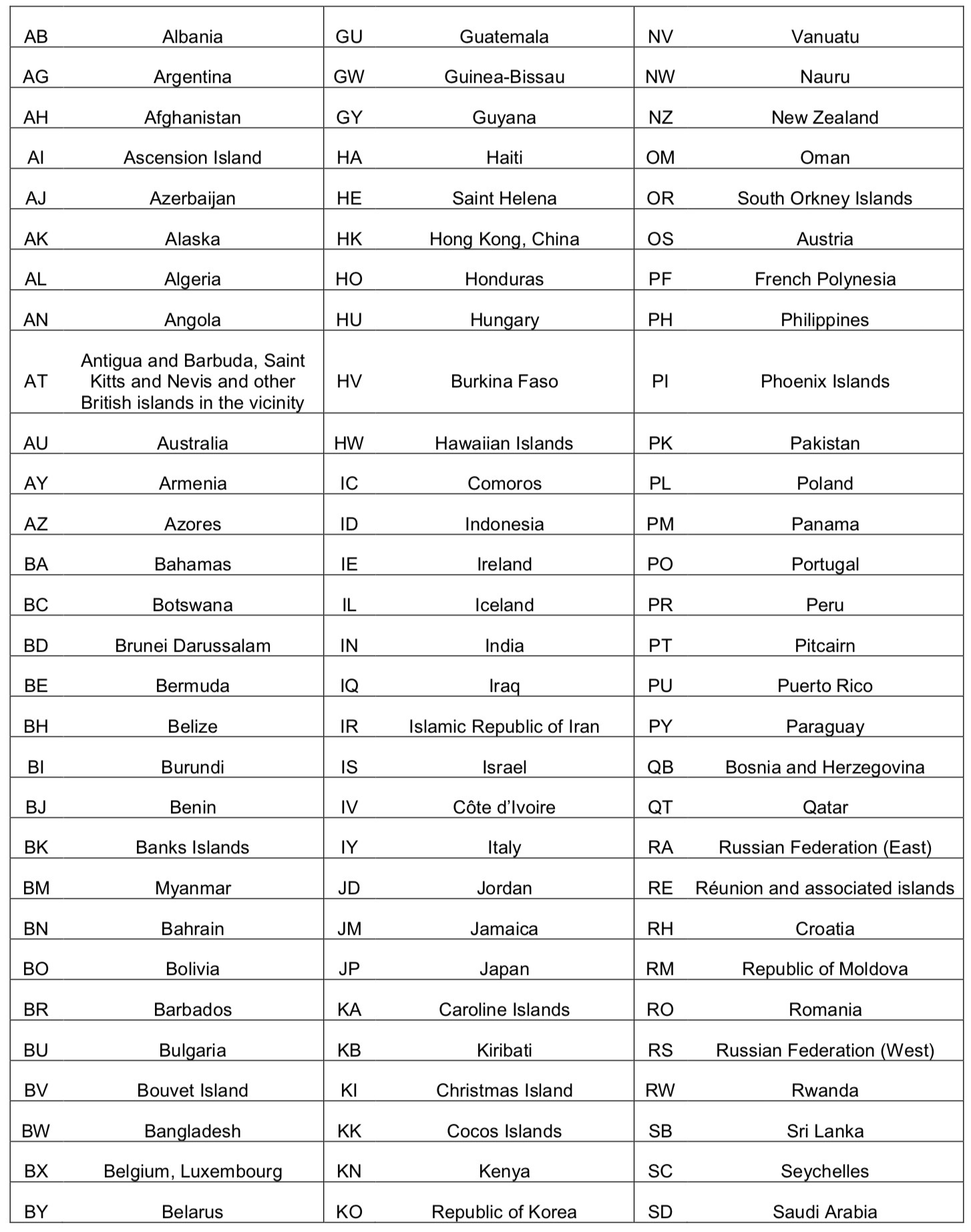
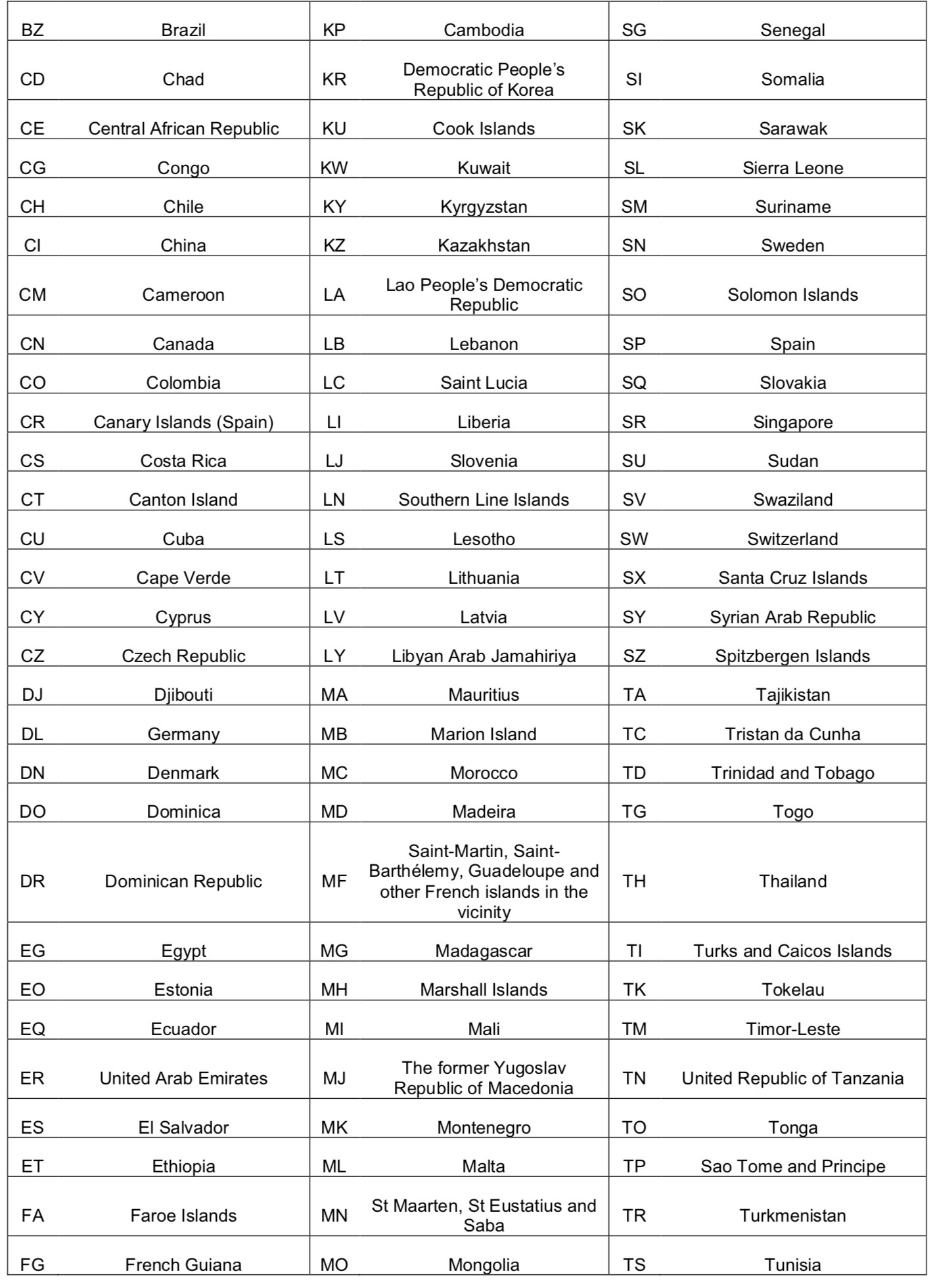
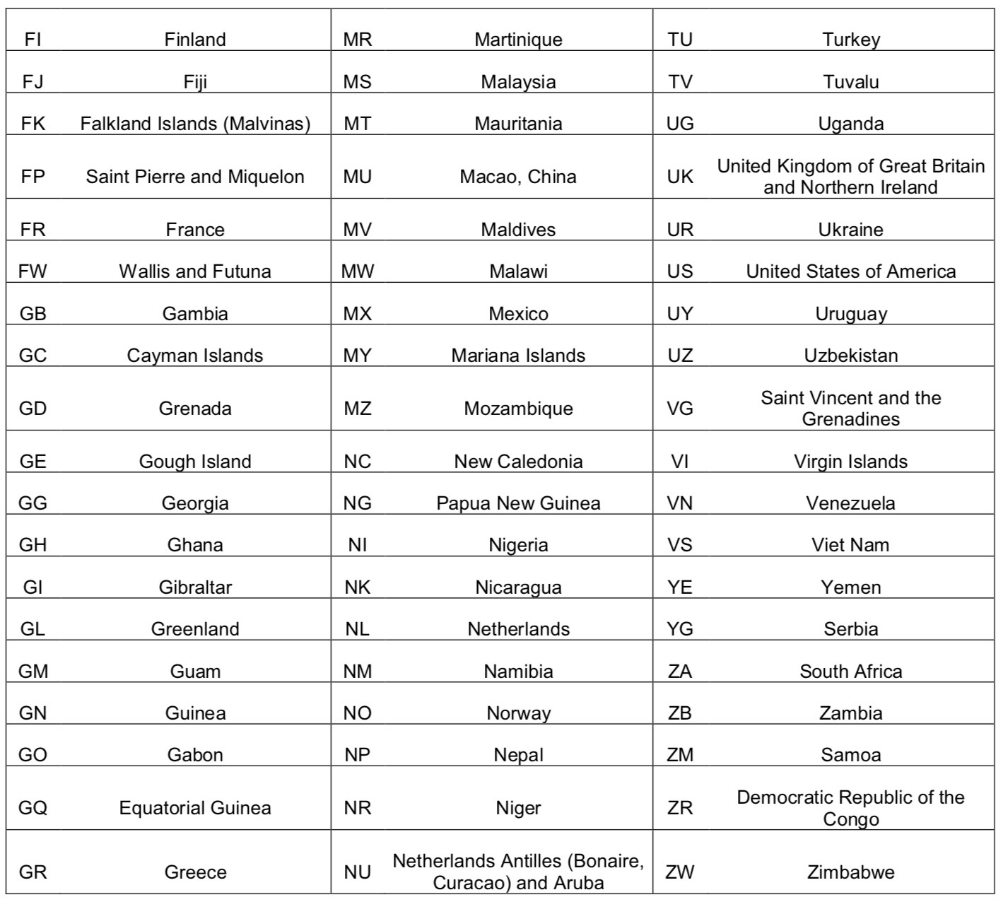
- BZ is the indication of the country where the message came from. In our example, Brazil;
- 21 is the bulletin number, assigned in the national level. It's not so relevant for our simulation.
-
SBRE is the FIR that disseminated the message. In this case, the Recife FIR;
-
150430 is the date and time of the dissemination of the message.
The first two digits is the date and the last four digits, the Zulu time (hour and minute). In this case, this example message was disseminated on day 15, at 0430Z.
A list of available codes and corresponding countries is available in Appendix 1 of this document.
¶ First Line
The first line of the SIGMET message contains the referred area of the observation/forecast (or where the observation/forecast is issued to), the identifier and daily sequence number, the period of validity (beginning and ending) and the station that made the observation/forecast which originated the message.
In our example:
- SBAO is where the observation/forecast where the SIGMET is issued to. In this case, the Atlantic FIR;
- SIGMET 1 is the type of the message and the sequential number of the day;
- VALID 150435/150835 is the period of validity of the message. It follows the same standard of the date/time of the header. In this case, it means that the message is valid between 0435Z of day 15 and 0835Z of day 15;
- SBRE- is the station which did the observation/forecast, As a coincidence, it's the same one that disseminated the message (per info in the header). The hyphen is the signal to separate the preamble of the message from its text).
¶ Second Line
The second line is the meteorological part of the SIGMET. It contains nine elements, as shown below:
- Location indicator of FIR(UIR) or CTA;
- Name of the FIR(UIR) or CTA;
- Description of the phenomenon;
- Observed or Forecasted;
- Location of observation/forecast;
- Level (altitude) of the observation/forecast;
- Movement or Expected Movement;
- Changes in intensity;
- Forecasted position at end of SIGMET's end of validity (optional).
In our example:
- SBAO ATLANTIC FIR is the Location Indicator and the Name of the FIR that holds the element of observation/forecast. That is, the element of weather report is located inside the SBAO FIR;
- EMBD TS is the description of the observed/forecasted phenomenon. In the example, Embedded Thunderstorms.
- FCST AT 0435Z means the information is a forecast. If OBS was written, it means that the information is an observation. When the information does not come with a time information, it means the exact time of observation/forecast is not known;
- WI S3154 W04804 - S3400 W05000 - S3400 W04625 - S3154 W04804 is the location of the forecast. When WI (Within) is stated, it means that the observation is INSIDE that polygon created by the geographic coordinates;
- TOP FL380 is the altitude of observation. It may be a specific flight level (FLxxx), a layer (FLxxx/yyy) or the indication of its top (TOP FLxxx). If an exact flight level cannot be defined, the use of terms ABV (Above) or BLW (Below) can be used. In our example, the top of those Embedded Thunderstorms inside the polygon above reaches the FL380;
- MOV NE 05KT indicates that the centre of the cloud mass is moving NORTHEAST at the speed of 5 knots (nm/h). If the abbreviation STNR is indicated, it means that the phenomenon is stationary;
- NC indicates that there's no change in the intensity of the phenomenon. If the phenomenon is becoming stronger, the term INTSF (Intensifying) is used. Else, if the phenomenon is becoming weaker, the term WKN (Weakening) is used;
- The equal sign (=) indicates the end of message.
Note that only the following phenomena are allowed for a SIGMET:
- Thunderstorms -- if they are Obscure/Obscuring/Obscured (OBSC), Embedded (in layer) (EMBD), Frequent (FRQ) or arranged in a Squall Line (SQL), with or without hail;
- Turbulence -- only Severe (SEV);
- Icing -- only Severe (SEV), with or without Freezing Rain (FZRA);
- Mountain Waves - only Severe (SEV);
- Dust Storm -- only Heavy (HVY);
- Sand Storm -- only Heavy (HVY);
- Radioactive Cloud.
¶ Tropical Cyclone SIGMET (TC SIGMET)
Let's see the example of a TC SIGMET, with a little different structure:
WCMX31 MMMX 150924 MMEX SIGMET 2 VALID 150918/151518 MMMX-
MMFR MEXICO FIR TC ODILE OBS N2342 W11024 AT 0918Z FRQ TS TOP FL520
WI 180NM OF CENTRE MOV NNW 14KT WKN. FCST TC CENTRE 151500 N2436 W11112=
The interpretation:
WCMX31 MMMX 150924 (...)
SIGMET for Tropical Cyclone (WC) at Mexico (MX) [WCMX31]. Message disseminated by MMMX [MMMX] at 0924Z of day 15 [150924].
(...) MMEX SIGMET 2 VALID 150918/151518 MMMX- (...)
The SIGMET message was issued to MMEX FIR, being the 2nd message of the day for that FIR [MMEX SIGMET 2]. It's valid between 0918Z of day 15 and 1518Z of day 15 [VALID 150918/151518]. The observation was done by MMMX station. End of preamble [MMMX-].
(...) MMFR MEXICO FIR TC ODILE OBS N2342 W11024 AT 0918Z FRQ TS TOP FL520 WI 180NM OF CENTRE MOV NNW 14KT WKN. FCST TC CENTRE 151500 N2436 W11112=
The observation was done inside MMFR (Mexico FIR) [MMFR MEXICO FIR]. The element of the observation is the Tropical Cyclone named 'Odile' [TC ODILE], with centre observed [OBS] at the position 23°42'N 110°24'W [N2342 W11024]. The observation was done at 0918Z [0918Z].
Frequent Thunderstorms [FRQ TRS] topped at FL520 [TOP FL520] within 180 nm of the cyclone's centre [WI 180NM OF CENTRE] are observed.
The cyclone is moving to north-northwest direction at the speed of 14 knots [MOV NNW 14KT], becoming weaker [WKN].
The station also forecasts the cyclone's centre [FCST TC CENTRE] at 1500Z of day 15 [151500] to be 24°36'N 111°12'W [N2436 W11112].
End of message [=].
¶ Volcanic Ash SIGMET (VA SIGMET/WV SIGMET)
Let's see the example of a VA SIGMET, with a little different structure:
WVID21 WAAA 151012 WAAF SIGMET A03 VALID 151230/151830 WAAA-
WAAF UJUNG PANDANG FIR VA ERUPTION MT DUKONO PSN N0141 E12753 VA CLD VA CLD OBS AT 151230Z WI N0140 E12755 -- N0210 E12725 - N0150 E12710 -- N0140 E12755 SFC/FL070 MOV NW 10KT FCST 1830Z WI N0140 E12755 -- N0140 E12755 - N0210 E12725 -- N0150 E12710 -- N0140 E12755 SFC/FL070=
The interpretation:
WVID21 WAAA 151012 (...)
SIGMET for Volcanic Ash (WV) at Indonesia (ID) [WVID21]. Message disseminated by WAAA [WAAA] at 1012Z of day 15 [151012].
(...) WAAF SIGMET A03 VALID 151230/151830 WAAA- (...)
The SIGMET message was issued to WAAF FIR, being the message sequenced as A03 of the day for that FIR [WAAF SIGMET A03]. It's valid between 1230Z of day 15 and 1830Z of day 15 [VALID 151230/151830]. The observation was done by WAAA station. End of preamble [WAAA-].
(...) WAAF UJUNG PANDANG FIR VA ERUPTION MT DUKONO PSN N0141 E12753 VA CLD VA CLD OBS AT 15/1230Z (...)
The observation was done inside WAAF (Ujung Pandang FIR) [WAAF UJUNG PANDANG FIR]. The element of the observation is a Volcanic Eruption [VA ERUPTION] from Mountain Dukono [MT DUKONO], which is located at position 01°41'N 127°53'E [PSN N0141 E12753]. A Volcanic Ash Cloud [VA CLD] was observed at 1230Z of day 15 [OBS AT 151230Z]. End of this section [VA CLD].
(...) WI N0140 E12755 -- N0210 E12725 - N0150 E12710 -- N0140 E12755 SFC/FL070 MOV NW 10KT (...)
The Volcanic Ash Cloud is located within the polygon delimited by the quoted points [WI N0140 E12755 -- N0210 E12725 - N0150 E12710 -- N0140 E12755], observed from surface to FL070 [SFC/FL070].
The mass of cloud is moving NORTHWEST, with the speed of 10 knots [MOV NW 10KT].
(...) FCST 1830Z
WI N0140 E12755 -- N0140 E12755 - N0210 E12725 -- N0150 E12710 -- N0140 E12755 SFC/FL070=
At 1830Z, the mass of VA Cloud is forecasted [FCST 1830Z] to be within the polygon delimited by the quoted points [N0140 E12755 -- N0140 E12755 - N0210 E12725 -- N0150 E12710 -- N0140 E12755], observed from surface to FL070 [SFC/FL070]. End of message [=].
¶ Cancellation of a SIGMET
If, during the validity period of a SIGMET, the phenomenon for which the SIGMET had been issued is no longer occurring or no longer expected, or if the observation/forecast has changed significantly from the original message, this SIGMET should be cancelled by the same organ that issued it by issuing another SIGMET, overriding the older one.
The structure is the following one:
WSQB31 LDZM 151306 LQSB SIGMET W4 VALID 151306/151500 LDZA-
LQSB SARAJEVO W UIR AND SARAJEVO FIR CNL SIGMET W3 151300/151500=
Which needs to be interpreted like:
WSQB31 LDZM 151306 (...)
SIGMET for Enroute Phenomenon (WS) at Bosnia and Herzegovina (QB) [WSQB31]. Message disseminated by LDZM [LDZM] at 1306Z of day 15 [151306].
(...) LQSB SIGMET W4 VALID 151306/151500 LDZA- (...)
The SIGMET message was issued to LQSB FIR, being the message sequenced as W4 of the day for that FIR [LQSB SIGMET W4]. It's valid between 1306Z of day 15 and 1500Z of day 15 [VALID 151306/151500]. The observation was done by LDZA station. End of preamble [LDZA-].
(...) LQSB SARAJEVO W UIR AND SARAJEVO FIR CNL SIGMET W3 151300/151500=
The observation was done inside LQSB (Sarajevo FIR/UIR) [LQSB SARAJEVO W UIR AND SARAJEVO FIR]. The instruction is to CANCEL the SIGMET message W3 (number of sequence) [CNL SIGMET W3], which was valid from 1300Z of day 15 to 1500Z of day 15 [151300/151500].
End of message [=].
¶ Other examples
Some examples for better understanding.
WSCH31 SCCI 151704 SCCZ SIGMET 1 VALID 151704/152104 SCCI-
SCCZ PUNTA ARENAS FIR SEV ICE FCST S OF S54 N OF S57 E OF W77 BTN FL040/FL150=
SIGMET for Enroute Phenomenon (WS) at Chile (CH) [WSCH31]. Message disseminated by SCCI [SCCI] at 1704Z of day 15 [151704]. The SIGMET message was issued to SCCZ FIR, being the message sequenced as 1 of the day for that FIR [SCCZ SIGMET 1]. It's valid between 1704Z of day 15 and 2104Z of day 15 [VALID 151704/152104]. The observation was done by SCCI station. End of preamble [SCCI-]. The observation was done inside SCCZ (Punta Arenas FIR) [SCCZ PUNTA AERINAS FIR]. Severe Icing is forecasted [SEV ICE FCST] at the area located SOUTH of latitude 54°S [S OF S54], NORTH of latitude 57°S [N OF S57] and EAST of longitude 77°W [E OF W77], between FL040 and FL150 [BTN FL040/FL150]. End of message [=].
WSCI35 ZJHK 151736 ZJSA SIGMET 7 VALID 151745/152145 ZJHK-
ZJSA SANYA FIR FRQ TS FCST S OF N2018 TOP FL450 MOV NW 30KMH INTSF=
SIGMET for Enroute Phenomenon (WS) at China (CI) [WSCI35]. Message disseminated by ZJHK [ZJHK] at 1736Z of day 15 [151736]. The SIGMET message was issued to ZJSA FIR, being the message sequenced as 7 of the day for that FIR [ZJSA SIGMET 7]. It's valid between 1745Z of day 15 and 2145Z of day 15 [VALID 151745/152145]. The observation was done by ZJHK station. End of preamble [ZJHK-]. The observation was done inside ZJSA (Sanya FIR) [ZJSA SANYA FIR]. Frequent Thunderstorm is forecasted [FRQ TS FCST] at the area located SOUTH of latitude 20°18'N [S OF N2018]. The top of the cloud mass is located at FL450 [TOP FL450]. The formation is moving to NORTHWEST at the speed of 30 km/h [MOV NW 30KMH] and it's intensifying [INTSF]. End of message [=].
WSRS37 RUAA 151657 ULAM SIGMET 1 VALID 151800/152200 ULAA-
ULAM NARYAN-MAR FIR SEV TURB FCST FL260/370 MOV SE 45 KMH NC=
SIGMET for Enroute Phenomenon (WS) at Russia (RS) [WSRS37]. Message disseminated by RUAA [RUAA] at 1657Z of day 15 [151657]. The SIGMET message was issued to ULAM FIR, being the message sequenced as 1 of the day for that FIR [ULAM SIGMET 1]. It's valid between 1800Z of day 15 and 2200Z of day 15 [VALID 151800/152200]. The observation was done by ULAA station. End of preamble [ULAA-]. The observation was done inside ULAM (Naryan-Mar FIR) [ULAM NARYAN-MAR FIR]. Severe Turbulence is forecasted [SEV TURB FCST] between the levels 260 and 370 [TOP FL450]. The turbulence area is moving to SOUTHEAST at the speed of 45 km/h [MOV SE 45KMH] with no changes in its strength [NC]. End of message [=].
¶ Appendix 1 -- List of Geographical Designators for SIGMET Header


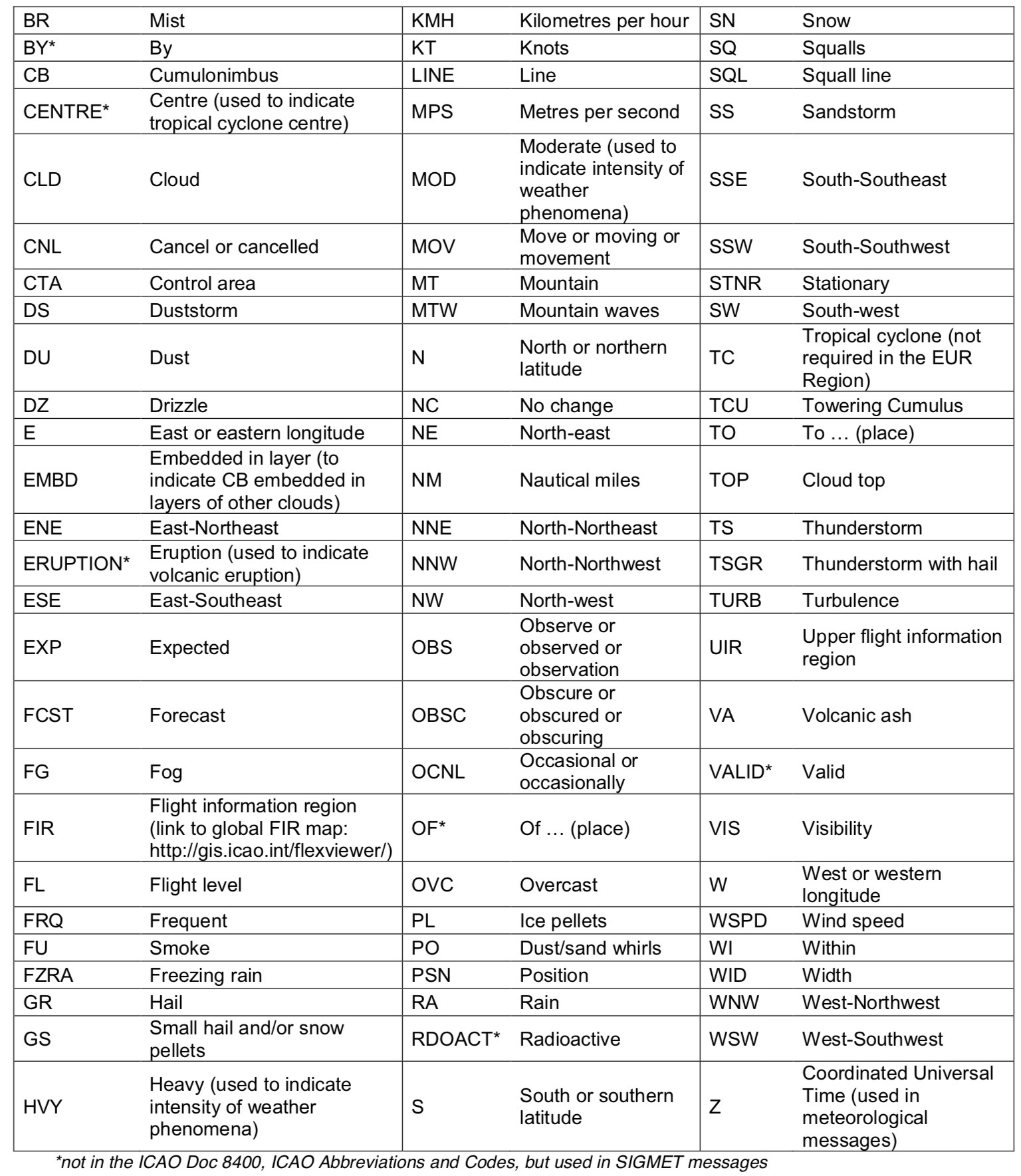
¶ Appendix 2 -- List of abbreviations that can appear in a SIGMET


- None
- ICAO documentation Annex 3 - Meteorological Service for International Air Navigation - 20th Edition July 2018 - Chapter 7
- VID 205631 - Creation
- VID 450012 - Wiki Integration
- VID 496402 - Wiki.js integration