¶ Introduction
Planning a cross-country flight cannot seem like an easy task. Flight planning can be a lot of work but the more you do it, the easier it gets! Here's a step-by-step process.
¶ Choose your flight
The first task is to choose a departure airfield and a destination airfield.
In real flight, the departure is where the airplane is parked. In IVAO, you have the opportunity to choose your departure airfield around the world.
You may need to fly to more than one airport or at least 150 nautical miles. During an IVAO exam or during personal training, you can fly in different types of airspace environments, and go to uncontrolled airfields or a busier towered airport.
Another thing to keep in mind is the route of flight based on the weather conditions and NOTAMs. Once you have a destination in mind, briefly check the weather and NOTAMs before you continue to ensure you will not run into bad weather or a closed runway.
For exam preparation, make sure the training objectives are being met, and you have no weak areas in your training.
¶ Choose your route
You should choose a route that will allow you to fly at an optimum altitude and cruise setting for your aircraft while still allowing you to easily identify checkpoints on the ground.
If you fly a small airplane, you might not be able to climb high enough to fly over a mountain range and your only option might be to go around it. Be aware of terrain, restricted and military areas and temporary flight restrictions when you plan your route. And also, take into account the VFR routes that go in and out of busy airports.
There are several methods to choose a route:
- Dead reckoning
- Radio navigation aids
- GPS
- Combination of all methods.
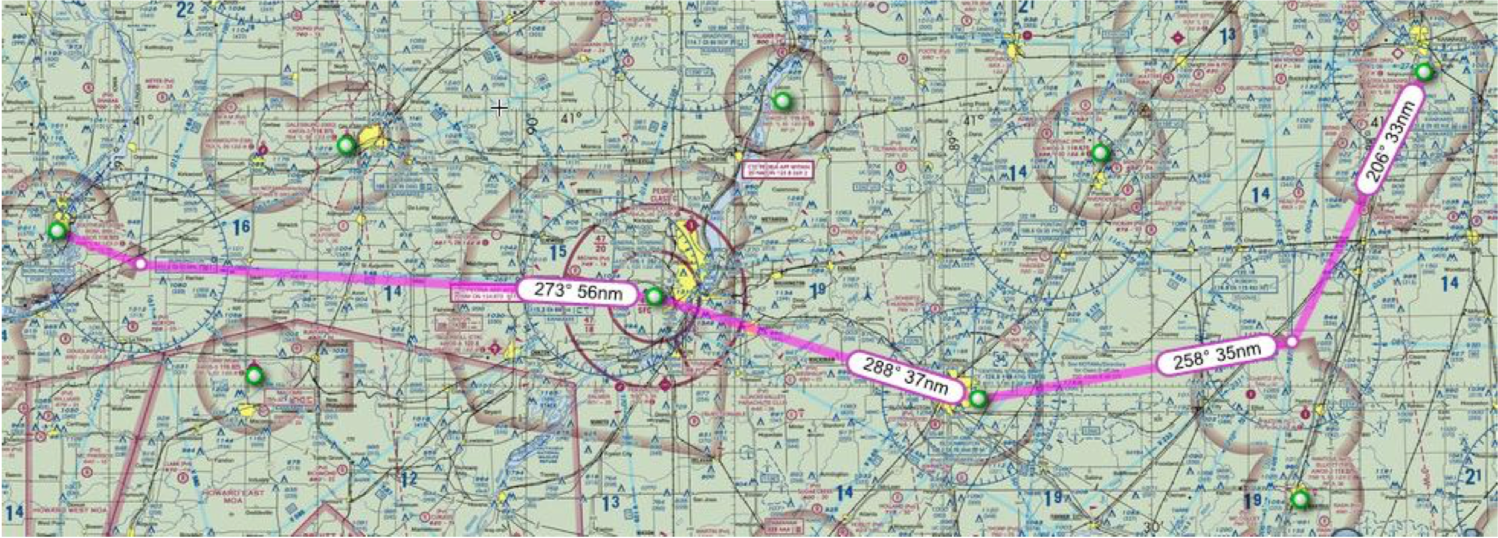
Once you choose your route, plot it out on a sectional map.
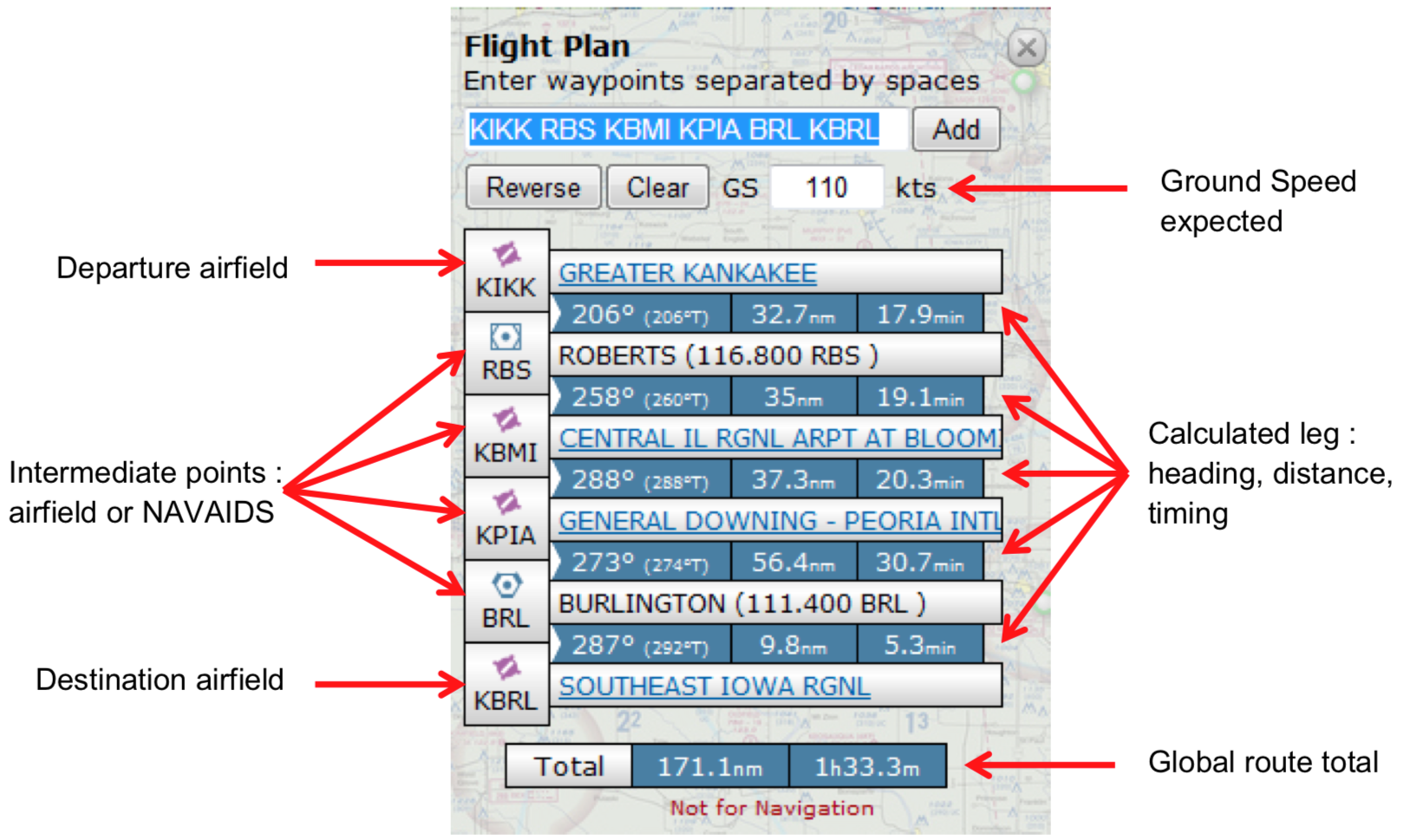
The pilot typically uses a flight planning log to keep track of the calculations during flight. You can use the website http://skyvector.com/

¶ Dead reckoning
At the most simple level, VFR navigation is accomplished through ideas known as dead reckoning and pilotage. Pilotage is a term that refers to the sole use of visual ground references. The pilot identifies landmarks, such as rivers, towns, airports, and buildings and navigates among them.
Choose checkpoints that are 5-10 nautical miles apart and are easy to identify. Lakes, rivers, towns, highways and other airports are usually easy to spot. Over very flat land with less-than-ideal checkpoints, you might get lost.
The trouble with pilotage is that often, references are not easily seen and cannot be easily identified in low visibility conditions or if the pilot gets off track even slightly. Therefore, the idea of dead reckoning was introduced.
Dead reckoning involves the use of visual checkpoints along with time and distance calculations. The pilot chooses checkpoints that are easily seen from the air and also identified on the map, and then calculates the time it will take to fly from one point to the next based on distance, airspeed, and wind calculations.
It is important to stay aware of your position at all times, so do not be afraid to plan a deviation from the straight-line path in order to find your way.
¶ Radio navigation
During visual meteorological conditions (VMC), a pilot might fly by using pilotage and dead reckoning alone, or he might use radio navigation aids or GPS navigation techniques.
With aircraft equipped with radio navigation aids, pilots can navigate more accurately than with dead reckoning alone. Radio NAVAIDS are useful in low visibility conditions and can be used as a back-up method for general aviation pilots. They are also more precise.
NAVAIDS are also required for IFR operations.
There are different types of radio NAVAIDS used in aviation:
- ADF/NDB: The most elementary form of radio navigation is the ADF/NDB pair. The ADF instrument
is basically an arrow pointer placed over a compass card-type display.
- VOR: The VOR system is probably the most commonly used NAVAID in the world. VOR is a radio-
based NAVAID that operates in the very-high-frequency range. VOR stations are located on the ground and transmit two signals -- one continuous 360-degree reference signal and another sweeping directional signal.
- DME: DME transmits on UHF frequencies, and computes slant-range distance. It is a basic method using a transponder in the aircraft to determine the time it takes for a signal to travel to and from a DME station.
¶ Modern navigation using GPS
The global positioning system has become the most valuable method of navigation in the modern aviation world. GPS has proven to be tremendously reliable and precise, and is probably the most common NAVAID in use today.
The global positioning system uses 24 U.S. Department of Defense satellites to provide precise location data, such as aircraft position, track, speed, and distance to pilots.
GPS has become a preferred method of navigating due to the accuracy and ease of use.
¶ Get a Weather Briefing
In the IVAO network, the weather can be obtained in several ways:
- Get METAR and/or TAF from the network using IVAO pilot interface
- Get METAR and/or TAF from real aviation system (be aware that some differences can exist
between IVAO and reality, even if IVAO takes the weather information from reality)
- Get weather information when reading ATIS of the air traffic controllers connected.
You must check the current weather information and forecast of your arrival airfield. But, do not forget to check the departure or intermediate airfield weather and forecast.
¶ Choose an altitude and cruise profile
As a VFR pilot, you should fly high enough to maintain the required clearance from terrain and obstacles, and should consider aircraft performance and the ability to find checkpoints from the air, as well.
The performance charts in the pilot operating handbook or pilot information manual for your aircraft can help you to determine an altitude and cruise power setting to use to get the best range or best endurance.
¶ Compute heading, time and distance
You will need to complete the speed, heading, distance and time for each leg of the flight, as well as fuel consumption. It is easiest to follow a navigation log form for this. You can do it by hand (with the help of a flight computer) or use a trusted computer.
Using a navigation log can help you organize the calculations in a way that makes sense and is easy to use.

¶ Familiarize yourself with the airports
If you have ever been stuck at a busy airport without an airport diagram, then you know that it is imperative to keep your situational awareness even after you land. If you are unfamiliar with them, large airports can be challenging and you can get lost yourself. Taxi instructions can be lengthy and your aircraft can be surrounded by medium or heavy aircraft.
A preliminary study of the ground layout especially for the biggest airfields is highly recommended. A check of airspace around the selected airfield you will cross is also recommended. Some airfields have several layers of airspace and it is sometimes hard to find when flying when you enter in controlled airspace.
In real aviation, you should want to know the hours of operation, fuel service availability and other services at your disposal.
¶ Check your equipment
If you are reliant on certain navigational instruments, make sure they work. Ensure the GPS database is up to date and working for your flight, and make sure the navigation instrument check has been done to ensure the VOR/NDB system is reliable. Also check that the charts are available and you do not miss one!
¶ File a flight plan
While you are getting your weather briefing and your route has been chosen, it is time to file a flight plan. In IVAO for a VFR flight, you can fill a short flight plan with no route. But declaring your route in your flight plan will help air traffic controllers to manage your flight.
For IVAO flight examination, the route is mandatory.
¶ Be Prepared for the Unexpected
Sometimes things do not go as planned. Be prepared mentally to adjust your plans as necessary:
- If the winds are stronger than predicted, you might need to adjust your calculations en route and
even update the flight plan and give a new ETA (estimated time arrival)
- If your VOR/NDB fails, you might need to rely more heavily on your map reading skills
- If the weather deteriorates, you may need to divert to a different airport or adjust your route
If you plan for the unexpected, you will be ready for anything
- None
- None
- VID 150259 - Creation
- VID 450012 - Wiki Integration
- VID 496402 - Wiki.js Integration