¶ Introduction
This OPMAN (Operation Manual) presents all the air procedures and rules applicable in the airspace of Haiti (MTEG FIR). In addition, the airports of Port-au-Prince (MTPP) and Cap-Haïtien (MTCH) are detailed (IFR and VFR procedures). Some country airfields are also presented (not exhaustive).
This document is the responsibility of the HQ ATC department. For any questions/comments, you can contact them via the following e-mail address : a-srdep@ivao.aero
Link to the AIP: https://ofnac.gouv.ht/
¶ History of modifications
| Version | Modifications | Validation month |
|---|---|---|
| 1 / 2022 | 2209 : Documentation creation | 09 / 2022 |
¶ Documentary organization
The OPMAN is divided into 4 parts:
- General rules and procedures (GEN),
This section will address national regulations and requirements, applicable units of measure, and services.
- En-route (ENR),
This section will cover ATS airspace, ATS routes, navigation aids and systems, and navigation hazards (P, R, D zones, ...).
- Aerodromes (AD).
This section will discuss aerodromes and heliports.
- Annex 1 (separate document) details the lateral boundaries of the FIR, TMA and CTR airspaces.
¶ General Rules and Procedures (GEN)
¶ Visual flight rules
Except for the case of special VFR; VFR flights will be conducted under the conditions detailed below:
-
ceiling above 450m (1500ft),
-
visibility of more than 5Km.
Unless authorized by ATS, VFR flights will only be conducted below 16,500 feet.
Except for operational purposes (take-off, landing), no VFR flights will be conducted below 300m (1000ft) of height from heavily populated areas ; within a radius of 600m.
Except for these areas, the overflight height must be 150m (500ft) above the ground, or ocean. Unless otherwise authorized, the sending of a flight plan is mandatory. All boxes (1 to 18) must be completed.
¶ Instrument flight rules
An aircraft in IFR flight in the cruise phase within controlled airspace will use a cruise level. See Appendix 3 of ICAO Annex 2.
Aircraft in IFR flight, entering a control area to land, will be cleared to the specified holding point. They will receive instructions from the approach controller (time, level, next position). These instructions must be respected. Otherwise the waiting procedure will be executed.
IFR departures from an uncontrolled aerodrome must contact the Area Control Center.
The Transition Altitude of the Port-au-Prince FIR is 17,000 feet. The first usable flight level is FL180.
An IFR flight plan must be sent and completed.
¶ ATS airspace classification
ATS airspaces are classified and designated as detailed in ICAO Annex 11, Chapter 2.6. No specific rules are complementary.
¶ Rules of the air
It is forbidden to fly over the cities of Port-au-Prince and Cap-Haitien at less than 8000 ft, except for take-off and landing. SSR equipment not existing on the Haitian facilities. The special measures for this equipment are not taken into account.
Primary radars are unable to detect the altitude and speed of an aircraft. The information given by the AURORA software is only a complementary tool to know the exact position of the aircraft. ATC manages the flow of traffic thanks to the pilots' position report (procedural control).
There is no published Minimum (Radar) Vectoring Altitude allowing air traffic management by "radar vectors". No heading can be provided to ensure safe obstacle clearance.
In the Terminal Control Area (TMA), in the Control Zone (CTR) position reports are mandatory for VFR flights.
¶ En-Route (ENR)
¶ ATS airspaces
¶ Horizontal sectorizations, TMA and CTR
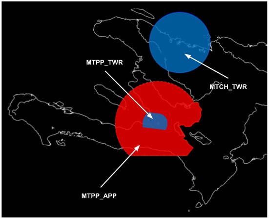
See below the ATC frequencies and the different airspace classes.
¶ Vertical sectorizations, TMA and CTR
| Name (Languages) |
Lateral limits | Vertical limits | Areas and conditions | Callsigns and Frequencies |
|---|---|---|---|---|
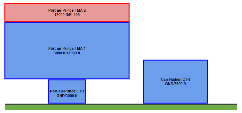
| Port-au-Prince CTR (French, English) |
See Annex 1 |
GND/3000ft | CTR - D airspace | Port-au-Prince Tower MTPP_TWR 118.300 MHZ |
| 3000ft/17000ft | TMA 1 - D airspace | Port-au-Prince Approach MTPP_APP 119.800 MHZ |
||
| 17000ft/FL195 | TMA 2 - A airspace | Port-au-Prince Approach MTPP_APP 119.800 MHZ |
||
| Cap-Haitien CTR (French, English) |
GND/7500ft | CTR - D airspace | Cap-Haitien Tower MTCH_TWR 118.700 MHZ |
¶ Horizontal sectorizations, FIR, CTA et UIR
Below, the sectors adjacent to the FIR of Haiti.
| Name (Languages) | Callsign | Frequencies |
|---|---|---|
| Havana FIR (English, Spanish) | MUFH_CTR (Havana Center) | 133.700 MHZ |
| Miami FIR (English) | KZMA_CTR (Miami Center) | 126.325 MHZ |
| Santo Domingo FIR (English, Spanish) | MDCS_CTR (Santo Domingo Control) | 124.300 MHZ |
| Curacao FIR (English) | TNCF_CTR (Curaçao Control) | 127.100 MHZ |
| Kingston FIR (English) | MKJK_CTR (Kingston Center) | 125.400 MHZ |
According to the previous table, here is the representation of the FIR airspace of Haiti.
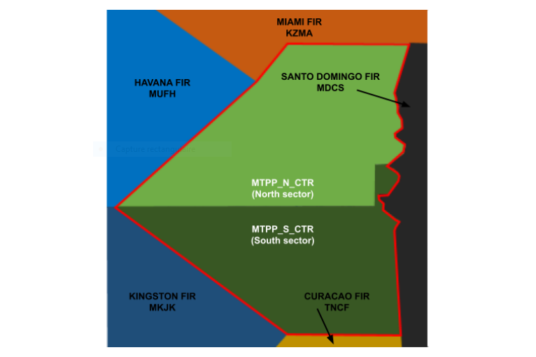
Without validated unbundling, only the MTEG_CTR sector is open on the 124.500 MHZ frequency (see below). The en-route sector (MTEG_CTR) is fully responsible for the Port-au-Prince FIR.
Additional information:
It is possible to unbundle the primary MTEG_CTR sector into two secondary sectors:
- MTPP_N_CTR : 124.500 MHZ (North Sector)
- MTPP_S_CTR : 134.150 MHZ (South Sector)
¶ Vertical sectorizations, FIR, CTA, UIR
| Name (Languages) | Lateral Limits | Vertical Limits | Areas and conditions | Callsigns Frequencies |
|---|---|---|---|---|
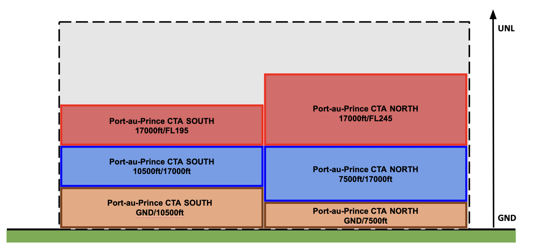
| Port-au-Prince FIR (French, English) |
See Annex 1 | 17000ft/FL245 | CTA North - A airspace | Port-au-Prince Center MTEG_CTR 124.500 MHZ |
| 7500ft/17000ft | CTA North - D airspace | |||
| GND/7500ft | CTA North - G airspace | |||
| 17000ft/FL195 | CTA South - A airspace | |||
| 10500ft/17000ft | CTA South - D airspace | |||
| GND/10500ft | CTA South - G airspace | |||
| FL195/UNL | FIR - A airspace | |||
| 3000ft/FL195 | FIR - D airspace | |||
| GND/3000ft | FIR - G airspace |
¶ ATS routes
¶ Lower ATS routes
This section details only the routes in the lower airspace.
| Designation of the route | Level | Route designation (FIX)* | Observation |
|---|---|---|---|
| A315 | Odd/Even | PIGBI ⇆ JOSES | D & A airspaces FL245/MEA |
| A756 | Odd/Even | BODLO ⇆ HCN | D & A airspaces FL245/MEA |
| A772 | Odd/Even | DCR ⇆ PAP | D & A airspaces FL245/MEA |
| A890 | Odd/Even | DEPSI ⇆ ETBOD | D & A airspaces FL245/MEA |
| G444 | Odd/Even | BOTES ⇆ LENOM | D & A airspaces FL245/MEA |
| H226 | Odd/Even | BOTES ⇆ SAVAR | D & A airspaces FL245/MEA |
| H227 | Odd/Even | ALBBE ⇆ HCN | D & A airspaces FL245/MEA |
| L212 | Odd/Even | ONPAD ⇆ URLAM | D & A airspaces FL245/MEA |
| L218 | Odd/Even | MODIT ⇆ PAP | D & A airspaces FL245/MEA |
| L304 | Odd/Even | ETBOD ⇆ BODLO | D & A airspaces FL245/MEA |
| L337 | Odd/Even | OSIDU ⇆ BODLO | D & A airspaces FL245/MEA |
| L349 | Odd/Even | NOSIS ⇆ DCR | D & A airspaces FL245/MEA |
| L577 | Odd/Even | KEBET ⇆ ETBOD | D & A airspaces FL245/MEA |
| M348 | Odd/Even | RETAK ⇆ ALBBE | D & A airspaces FL245/MEA |
| M594 | Odd/Even | KEBET ⇆ ALBBE | D & A airspaces FL245/MEA |
| M596 | Odd/Even | MUPOV ⇆ ETBOD | D & A airspaces FL245/MEA |
| Q301 | Odd/Even | JOSES ⇆ LENOM | D & A airspaces FL245/MEA |
* This column informs only the two points at the ends of the route.
¶ Upper ATS routes
| Designation of the route | Level | Route designation (FIX)* | Observation |
|---|---|---|---|
| UA315 | Odd/Even | PIGBI ⇆ JOSES | A airspace UNL/FL245 |
| UA756 | Odd/Even | BODLO ⇆ NOSOX | A airspace UNL/FL245 |
| UA890 | Odd/Even | DEPSI ⇆ ETBOD | A airspace UNL/FL245 |
| UG444 | Odd/Even | BOTES ⇆ LENOM | A airspace UNL/FL245 |
| UL212 | Odd/Even | ONPAD ⇆ URLAM | A airspace UNL/FL245 |
| UL218 | Odd/Even | MODIT ⇆ PAP | A airspace UNL/FL245 |
| UL304 | Odd/Even | ETBOD ⇆ BODLO | A airspace UNL/FL245 |
| UL337 | Odd/Even | OSIDU ⇆ BOLDO | A airspace UNL/FL245 |
| UL349 | Odd/Even | NOSIS ⇆ DCR | A airspace UNL/FL245 |
| UL577 | Odd/Even | KEBET ⇆ ETBOD | A airspace UNL/FL245 |
| UM348 | Odd/Even | RETAK ⇆ ALBBE | A airspace UNL/FL245 |
| UM594 | Odd/Even | KEBET ⇆ ALBBE | A airspace UNL/FL245 |
| UM596 | Odd/Even | MUPOV ⇆ ETBOD | A airspace UNL/FL245 |
| UQ301 | Odd/Even | JOSES ⇆ LENOM | A airspace UNL/FL245 |
* This column informs only the two points at the ends of the route.
¶ Radio navigation aids/systems en-route
| Name of station | ID | Frequencies | Coordinates | Elevation |
|---|---|---|---|---|
| Port-au-Prince VOR/DME | PAP | 115.300 MHZ | 18°34’59”N 072°18’00”W | 154ft |
| Cap-Haïtien VOR/DME | HCN | 113.900 MHZ | 19°42’91”N 072°12’60”W | 34ft |
¶ Navigation warnings
¶ Prohibited areas
| Identification | Lower/Upper limits | Remarks |
|---|---|---|
| MT(P) - 3 (PROHIBITED) Hydraulic dam of Peligre | Ground / FL140 | Rectangle by the following coordinates: 18°50’00”N 071°50’00”W - 18°50’00”N 072°10’00”W - 19°10’00”N 071°50’00”W - 19°10’00”N 072°10’00”W - |
| MT(P) - 4 (PROHIBITED) Cabaret Earth Station | Ground / 6500ft AMSL | Circle 1 NM radius centered on: 18o44’44”N 072o24’31”W |
| MT(P) - 5 (PROHIBITED) La Ferrière Citadel | Ground / 5500ft AMSL | Circle 2 NM radius centered on: 19o34’25”N 072o14’38”W |
¶ Restricted areas
Non-existent
¶ Danger areas
Non-existent
¶ AERODROMES (AD)
¶ Port-au-Prince - MTPP
¶ Airport Information
| Informations | |
|---|---|
| ICAO Code | MTPP |
| IATA Code | PAP |
| Airport name | Toussaint Louverture Intl. Airport (Port-au-Prince) |
| Time zone conversion | UTC -5 |
| Coordinates of the reference point and location of the airfield | 18° 34’ 48.18 N 072° 17’ 33.15 W |
| Direction and distance from (city) | 040° / 3.5km of Port-au-Prince |
| Altitude / temperature reference | 37m (122 feet) / 35°C |
| Magnetic declination | 9.97° W |
| Permitted traffic types | IFR / VFR |
| Runway | 10 / 28 |
¶ Characteristic of the runway
The runway 10-28 has the following features:
| Description of the runway | Runway 10 | Runway 28 |
|---|---|---|
| Dimensions of runway (m) | 3040 x 43 | 3040 x 43 |
| True and Mag Brg | 087° True / 096° Mag | 267° True / 276° Mag |
| Strength (PCN) and surface of runway | 56/R/C/W/T concrete | 56/R/C/W/T concrete |
| Threshold coordinates | 18°34’45.58 N 072°18’24.92 W | 18°34’50.79 N 072°16’41.37 W |
| Threshold elevation | Threshold 24m (79ft) | Threshold 37m (122ft) |
| TORA (m) | 3040 | 3040 |
| TODA (m) | 3360 | 3360 |
| ASDA (m) | 3040 | 3040 |
| LDA (m) | 3040 | 3040 |
¶ ATS Communication facilities
| Designation service | Call sign | Frequency |
|---|---|---|
| Approach | Port-au-Prince Approach (MTPP_APP) | 119.800 MHZ |
| Tower | Port-au-Prince Tower (MTPP_TWR) | 118.300 MHZ |
¶ Radio navigation and landing aids
| Type of aid | ID | Frequency | Informations |
|---|---|---|---|
| VOR/DME | PAP | 115.300 MHZ | 18°34’36 N 072°18’15 W |
| ILS/DME | IMG | 111.500 MHZ | 097° |
| NDB | HHP | 270.00 | / |
¶ Local airport regulation
¶ Automatic Terminal Information Service
The ATIS must be completed in English.
The ATIS can also be completed in French if ATC wishes.
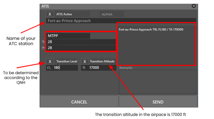
At the beginning of the session, please fill out the ATIS correctly. The transition altitude (TA) is 17000ft. The transition level (TL) is to be determined according to the QNH. The first usable level is FL180. There is no preferential runway, however an ILS procedure is available on runway 28. Any special information can be marked in the "remarks" box.
| Type of aid | Frequency |
|---|---|
| Port-au-Prince | 132.075 MHZ |
¶ Traffic areas
The Tower will assign a gate number to arriving aircraft. General aviation aircraft will be required to use their designated apron area.
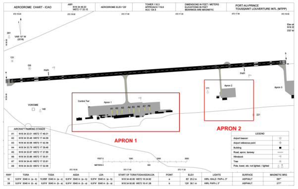
Apron 1 is intended for regular commercial aviation, and Apron 2 for general aviation.
¶ Aircraft gate management
Located in front of the terminal (Apron 1), the commercial aviation parking lot has 8 parking spaces for the different categories (see below).
| Gates | Airlines | Aircraft types |
|---|---|---|
| A1 | American Airlines - Kalitta Charters II | B737 - A320 |
| A2 | Winair - Air Antilles | DHC6 - AT46 |
| A3 | Spirit Airlines | A20N - A321 |
| A4 | JetBlue Airways - Sunrise Airways | A320 - A321 |
| A5 | JetBlue Airways | A320 - A321 |
| A6 | Air Transat - Jetair Caribbean | A330 - F70 |
| A7 | Sunrise Airways - National Air Charters | A320 - EM2 - J32 |
| A8 | Sunrise Airways - National Air Charters | A320 - EM2 - J32 |
¶ Squawk code
For better traffic management in the Haitian airspace, here are the squawk codes to assign to traffic according to their destination.
| Flight | Code |
|---|---|
| Domestic IFR | 1300 - 1377 and 1400 - 1477 |
| International IFR | 5400 - 5477 and 7100 - 7177 |
| VFR | 1200 |
¶ Characteristics of the taxiways
The taxiways do not have names. They are commonly called taxiways for Apron 1 or Apron 2.
| Taxiways description | Apron 1 taxiway | Apron 2 taxiway |
|---|---|---|
| Taxiway width (m) | 22 | 14 |
| Geographical coordinates of the appropriate axial points of the taxiways | 18°34’44N - 072°17’40W 18°34’38 N - 072°17’40 W |
18°34’46N - 072°17’05W 18°34’41 N - 072°17’05 W |
¶ CTR description
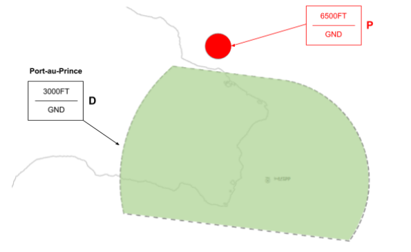
Toussaint Louverture airport has a class D CTR, starting from the surface, and going up to 3000 FT AMSL. North of this CTR, a Zone P is in operation, from the surface to 6500 FT AMSL.
The aerodrome traffic circuit is not published, however this information "flights over populated areas and the cities of Port-au-Prince and Cap-Haitien are prohibited below an altitude of 2400m (8000 feet) QNH", available in the AIP, allows us to affirm that the great majority of the aerodrome traffic circuits are to the north of the facilities, at 1200 FT.
¶ VFR entries, exits, transits in CTR
CTR entries and exits are normally made from the North and from the South after coordination with the approach controller. VFR transits will pass vertically from the airport at least 500ft above the aerodrome traffic patterns altitude.
¶ TMA area description
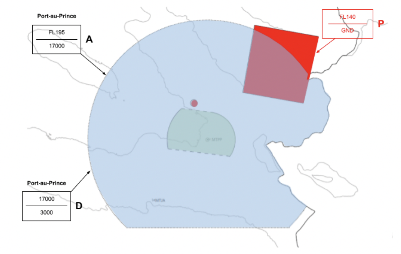
The control sector of Port-au-Prince is divided into 2 TMA. The responsible ATC station is the Port-au-Prince approach.
¶ Prohibited zone (TMA area)
| Identification | Lower limit | Upper limit | Activity |
|---|---|---|---|
| MT(P) - 4 (PROHIBITED) | Ground | 6500ft AMSL | Cabaret Earth Station |
| MT(P) - 3 (PROHIBITED) | Ground | FL140 | Hydraulic dam of Peligre |
¶ Standard instrument departure
| Runway | SID | RNAV or conventional SID | Altitude or FL |
|---|---|---|---|
| 28 | ALPIG 1N | RNP | To be determined by ATC above 4900ft |
| DEPLO 1N | To be determined by ATC above 7600ft | ||
| SAVAR 1N | To be determined by ATC above 7600ft | ||
| KENOK 1N | To be determined by ATC above 10500ft | ||
| MAROT 1N | To be determined by ATC above 4900ft | ||
| MESLI 1N | To be determined by ATC above 10500ft | ||
| PETBA 1N | To be determined by ATC above 10500ft | ||
| TOVOL 1N | To be determined by ATC above 10500ft | ||
| ETBOD 1N | To be determined by ATC above 10500ft | ||
| 10 | SEDET 1G | RNP | To be determined by ATC above 7600ft |
| SAVAR 1G | To be determined by ATC above 7600ft | ||
| ALPIG 1G | To be determined by ATC above 4900ft | ||
| MAROT 1G | To be determined by ATC above 4900ft | ||
| PETBA 1G | To be determined by ATC above 10500ft | ||
| MESLI 1G | To be determined by ATC above 10500ft | ||
| MESLI 1S * | To be determined by ATC above 10500ft | ||
| TOVOL 1S | To be determined by ATC above 10500ft | ||
| KENOK 1S | To be determined by ATC above 10500ft | ||
| ETBOD 1S | To be determined by ATC above 10500ft | ||
| SEDET 1F * | To be determined by ATC above 7600ft | ||
| SAVAR 1F * | To be determined by ATC above 7600ft | ||
| ALPIG 1F * | To be determined by ATC above 4900ft | ||
| MAROT 1F * | To be determined by ATC above 4900ft | ||
| PETBA 1F * | To be determined by ATC above 10500ft | ||
| MESLI 1F | To be determined by ATC above 10500ft |
*This means that this procedure is preferable to the other SIDs (for the same first point en route).
¶ Standard instrument terminal arrival
| Runway | STAR | Observations |
|---|---|---|
| STAR 3 RWY 28 (RNP 1 REQUIRED) (GNSS REQUIRED) |
MESLI 1B TOVOL 1B KENOK 1B |
250kt maximum on ETBOD (IAF) 5200ft at ETBOD or above |
| STAR 2 RWY 28 (RNP 1 REQUIRED) (GNSS REQUIRED) |
KENOK 1D ETBOD 1D TOVOL 1D MESLI 1D MAROT 1D ALPIG 1D SAVAR 1D SEDET 1D NABEN 1D |
250kt maximum on BADEE (IAF) 6300ft at BADEE or above |
| STAR 1 RWY 10 (RNP 1 REQUIRED) (GNSS REQUIRED) |
KENOK 1C TOVOL 1C MESLI 1C PP999 1C ALPIG 1C SAVAR 1C ETBOD 1C |
250kt maximum on CAPOI (IAF) 4000ft at CAPOI or above |
¶ Instrument approach procedures
| Runway | Approach | IAF | FAF | Beacon |
|---|---|---|---|---|
| 10 | RNAV (GNSS) | CAPOI | FAF10 3000ft |
/ |
| ILS (Y) | PAP (115.3) AVOLI / MENTU |
9,2 NM of IMG 3000ft |
IMG 111.5 | |
| ILS (Z) | CAPOI | FAF10 3000ft |
IMG 111.5 | |
| VOR DME | PAP (115.3) AVOLI / MENTU |
9,2 NM of PAP | PAP (115.3) | |
| 28 | RNAV (GNSS) | CAPOI / BADEE / ETBOD | FAF28 2000ft |
/ |
¶ Cap-Haïtien - MTCH
¶ Airport Information
| Informations | |
|---|---|
| ICAO Code | MTCH |
| IATA Code | CAP |
| Airport name | Cap-Haïtien Intl. Airport (Cap-Haïtien) |
| Time zone conversion | UTC -5 |
| Coordinates of the reference point and location of the airfield | 19° 43’ 38.10 N 072° 11’ 58.29 W |
| Direction and distance from (city) | 002° / 3.7km of Cap-Haîtien |
| Altitude / temperature reference | 4m (14 feet) / 35°C |
| Magnetic declination | 9.97° W |
| Permitted traffic types | IFR / VFR |
| Runway | 05 / 23 |
¶ Characteristic of the runway
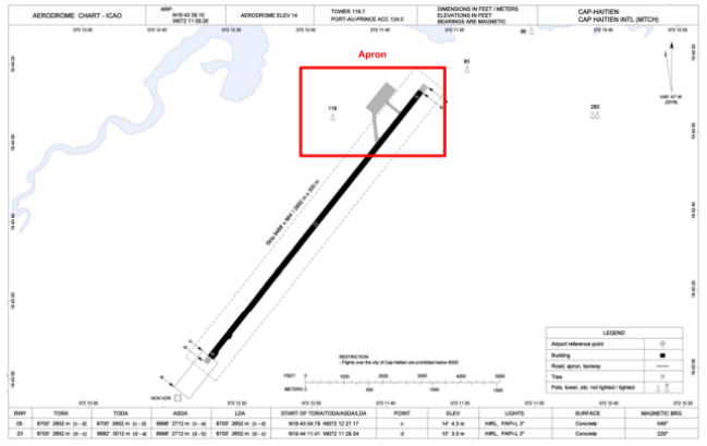
The runway 05-23 has the following features:
| Description of the runway | Runway 05 | Runway 23 |
|---|---|---|
| Dimensions of runway (m) | 2652 x 45 | 2652 x 45 |
| True and Mag Brg | 039° True / 048° Mag | 219° True / 228° Mag |
| Strength (PCN) and surface of runway | 54/R/C/W/T concrete | 54/R/C/W/T concrete |
| Threshold coordinates | 19°43’04.93 N 072°12’27.03 W | 19°44’11.25 N 072°11’29.46 W |
| Threshold elevation | Threshold 7m (24ft) | Threshold 6m (19ft) |
| TORA (m) | 2652 | 2652 |
| TODA (m) | 2652 | 2652 |
| ASDA (m) | 2712 | 2712 |
| LDA (m) | 2652 | 2652 |
¶ ATS Communication facilities
| Designation service | Call sign | Frequency |
|---|---|---|
| Tower | Cap-Haïtien Tower (MTCH_TWR) | 118.700 MHZ |
¶ Radio navigation and landing aids
| Type of aid | ID | Frequency | Informations |
|---|---|---|---|
| VOR/DME | HCN | 113.9 MHZ | 19°42’54 N 072°12’36 W |
| NDB | HTN | 288.00 | / |
¶ Traffic areas
The Tower will assign a gate number to arriving aircraft. General aviation aircraft will be required to use the same apron area.
¶ Aircraft gate management
Located in front of the terminal, the commercial aviation parking lot has 3 parking spaces for the different categories (see below).
| Gates | Airlines | Aircraft types |
|---|---|---|
| 1 | Sunrise Airways - Caicos Express Airways | J32 - EM2 - BE1 |
| 2 | Spirit Airlines | A20N |
| 3 | IBC Airways - InterCaribbean Airways | E145 - E120 |
¶ Characteristics of the taxiways
The taxiways do not have names. They are commonly called taxiways for North or South.
| Taxiways description | North taxiway | South taxiway |
|---|---|---|
| Taxiway width (m) | 22 | 14 |
| Geographical coordinates of the appropriate axial points of the taxiways | 19°44’06 N - 072°11’35 W 19°44’08 N - 072°11’38 W |
19°43’59 N - 072°11’41 W 19°44’05 N - 072°11’41 W |
¶ CTR description
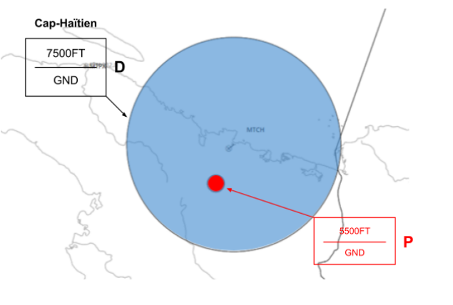
Cap-Haïtien airport has a class D CTR, starting from the surface, and going up to 7500 FT AMSL. South of this CTR, a Zone P is in operation, from the surface to 5500 FT AMSL. The aerodrome traffic circuit is not published.
¶ VFR entries, exits, transits in CTR
CTR entries and exits are normally made from the West and from the South. VFR transits will pass vertically from the airport at least 500ft above the aerodrome traffic patterns altitude.
¶ TMA area description
There are no plans for an approach position at this time. Departures and arrivals are managed by the Port-au-Prince center.
¶ Prohibited zone (CTR area)
| Identification | Lower/Upper limits | Activity | |
|---|---|---|---|
| MT(P) - 5 (PROHIBITED) | Ground | 5500ft AMSL | La Ferrière Citadel |
¶ Standard instrument departure
| Runway | RNAV or conventional SID | Altitude or FL | |
|---|---|---|---|
| 05 (RNP 1 REQUIRED) | SAVAR 1N | RNP | To be determined by ATC Above 6300ft |
| MEDON 1N | To be determined by ATC Above 5400ft | ||
| NOSOX 1N | To be determined by ATC Above 3700ft | ||
| ALBEE 1N | |||
| RETAK 1N | |||
| SEDET 1N | To be determined by ATC Above 5300ft | ||
¶ Standard instrument terminal arrival
| Runway | STAR | Observations |
|---|---|---|
| STAR 1 RWY 05 (RNP 1 REQUIRED) |
SAVAR 1N SEDET 1N MEDON 1N NOSOX 1N TUMAR 1N |
220kt maximum on DALCY (IAF) 6500ft at DALCY or above 220kt maximum on PBORO (IAF) 5400ft at PBORO or above |
| STAR 2 RWY 23 (RNP 1 REQUIRED) |
MEDON 1S NOSOX 1S TUMAR 1S RETAK 1S SEDET 1S SAVAR 1S |
230kt maximum on HOCAP (IAF) 2500ft at HOCAP or above 230kt maximum on PODPE (IAF) 2500ft at PODPE or above 230kt maximum on ZAMMI (IAF) 2500ft at ZAMMI or above |
| STAR 3 RWY 23 (RNP 1 REQUIRED) (RF CAPABILITY REQUIRED) |
TUMAR 1L NOSOX 1L NOSOX 1F |
250kt maximum on LACUL(IAF) 3400ft at LACUL or above 250kt maximum on FOSET (IAF) 3400ft at FOSET or above |
¶ Instrument approach procedures
| Runway | Approach | IAF | FAF | Beacon |
|---|---|---|---|---|
| 05 | RNAV (GNSS) Z | PBORO DALCY |
CH408 4600ft | / |
| RNAV (GNSS) Y | LACUL / FOSET | CH603 3200ft | / | |
| VOR/DME | HCN (113.9) SAVAR TUMAR |
LEPAV 2700ft | HCN (113.9) | |
| 23 | RNAV (GNSS) | HOCAP / ZAMMI PODPE | CH508 2500ft | / |
| VOR/DME | HCN (113.9) SAVAR TUMAR |
AMOKA 2000ft | HCN (113.9) |
¶ Cayes - MTCA
¶ Airport Information
| Information | |
|---|---|
| ICAO Code | MTCA |
| Airport name | Antoine-Simon Airport (Les Cayes) |
| Coordinates of the reference point and location of the airfield | N 18°16'15 W 073°47'17 |
| Altitude / temperature reference | 62m (203 feet) / 35°C |
| Permitted traffic types | VFR |
| Runway | 08 / 26 |

¶ Characteristic of the runway
The runway 08-26 has the following features:
| Description of the runway | Runway 08 | Runway 26 |
|---|---|---|
| Dimensions of runway (m) | 1013 X 24 | 1013 X 24 |
| Mag Brg | 075° Mag | 255° Mag |
| Surface of runway | Asphalt | Asphalt |
| Threshold Coordinates | N18°16'11.81 W073°47'34.59 |
N18°16'20.13 W073°47'01.08 |
¶ ATS Communication facilities
| Designation service | Call sign | Frequency |
|---|---|---|
| Tower | Cayes Tower | 118.500 MHZ (air-to-air station) |
¶ Jacmel - MTJA
¶ Airport Information
| Information | |
|---|---|
| ICAO Code | MTJA |
| Airport name | Jacmel Airport |
| Coordinates of the reference point and location of the airfield | N18°14'27 W072°31'06 |
| Altitude / temperature reference | 51m (167 feet) / 35°C |
| Permitted traffic types | VFR |
| Runway | 01 / 19 |
¶ Characteristic of the runway
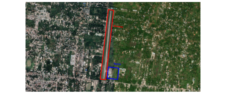
The runway 01-19 has the following features:
| Description of the runway | Runway 01 | Runway 19 |
|---|---|---|
| Dimensions of runway (m) | 1030 X 29 | 1030 X 29 |
| Mag Brg | 005° Mag | 185° Mag |
| Surface of runway | Asphalt | Asphalt |
| Threshold Coordinates | N18°14'11.04 W072°31'08.04 |
N18°14'44.04 W072°31'04.08 |
¶ Jacmel - MTJE
¶ Airport Information
| Information | |
|---|---|
| ICAO Code | MTJE |
| Airport name | Jeremie Airport |
| Coordinates of the reference point and location of the airfield | N18°40'00 W074°09'59 |
| Altitude / temperature reference | 45m (147 feet) / 35°C |
| Permitted traffic types | VFR |
| Runway | 09 / 27 |

¶ Characteristic of the runway
The runway 09-27 has the following features:
| Description of the runway | Runway 09 | Runway 27 |
|---|---|---|
| Dimensions of runway (m) | 1207 X 45 | 1207 X 45 |
| Mag Brg | 083° Mag | 263° Mag |
| Surface of runway | Asphalt | Asphalt |
| Threshold Coordinates | N18°39'57.63 W074°10'20.35 |
N18°40'02.37 W074°09'39.63 |
¶ Jacmel - MTPX
¶ Airport Information
| Information | |
|---|---|
| ICAO Code | MTPX |
| Airport name | Port-de-Paix Airport |
| Coordinates of the reference point and location of the airfield | N19°55'59 W072°50'59 |
| Altitude / temperature reference | 3m (9 feet) / 35°C |
| Permitted traffic types | VFR |
| Runway | 06 / 24 |

¶ Characteristic of the runway
The runway 06-24 has the following features:
| Description of the runway | Runway 06 | Runway 24 |
|---|---|---|
| Dimensions of runway (m) | 643 X 45 | 643 X 45 |
| Mag Brg | 053° Mag | 233° Mag |
| Surface of runway | Concrete | Concrete |
| Threshold Coordinates | N19°55'53.76 W072°51'08.78 |
N19°56'06.22 W072°50'51.02 |