¶ OBJECTIVES
After reading this guide you should be able to:
- Select an appropriate NAT or random track for crossing.
- File a correct Atlantic routing
- Enter the Atlantic correctly.
- Exit the Atlantic correctly.
¶ HOPPIE
We strongly encourage anyone with a capable aircraft to use Hoppie (free) for realistic CPDLC/DCL communication right fro your aircraft and IVAO ATC.
You can read this guide on how to get started with Hoppie.
¶ THE ORGANISED TRACK SYSTEM

The OTS is simpy a term for the famouse North Atlantic Tracks (NAT).
Now, what are the North Atlantic Tracks? In essence, they are one-way airways. The tracks are defined and governed by two factors:
- The Jetstream
- User Input
The latter largely is affected by the former.
The jetstream is a strong upper-level wind which is poised at the edge of the troposphere. It can reach speeds of 150 knots easily. It blows generally from west to east, hence it is aimed to keep the Westbound Tracks out of it as much as possible. By contrast the Eastbound Tracks are aligned to be in the tracks, thus maximising ground speed.
The tracks are calculated and published twice daily by the control centres at Gander (in Newfoundland) and Shanwick (in the UK and Ireland).
The airlines flying the Atlantic regularly send Preferred Route Messages to Shanwick and Gander indicating their requests. By a rule Shanwick issues the westbound tracks, Gander does the eastbound tracks.
Are there other control centres involved?
Yes, there are, the other key players are Santa Maria, New York, Reykyavik and Bodo, Norway.
¶ Westbound Tracks
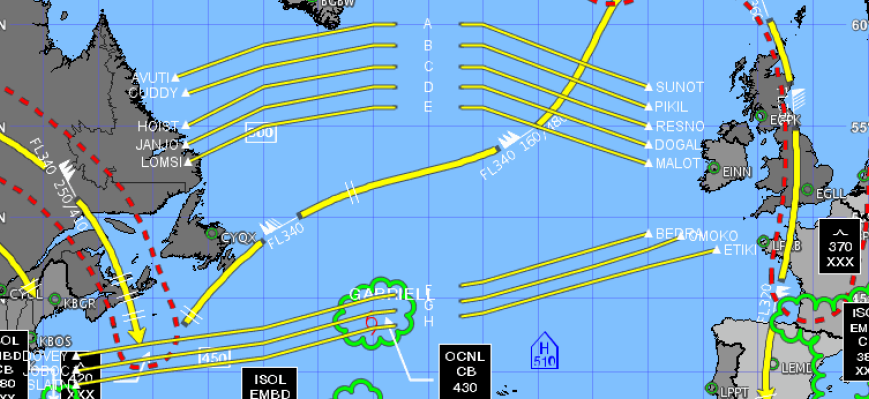
The tracks are labelled A-M (No I), A is ALWAYS the northernmost track. Not all track letters are used every day, the exact number of NATs depends on the day of the week and the season as the exact number of flights vary.
Notice how the Tracks are arranged to keep away from the brunt of the Jetstream (bold yellow line at FL340)
¶ Eastbound Tracks
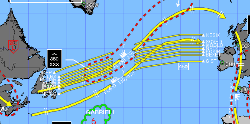
Eastbound tracks are labelled P-Z, this is the maximum scope of tracks, Tracks P, Q, R and S are not always used, this depends on the day of the week, the season and expected traffic volume.
The southern most track is always Z.
Notice the tracks are laid into the jetstream to maximise tailwind use:
¶ NAT Briefing
Having seen the general picture, let's have a look at how the tracks are composed. To find out what the tracks are there are several ways and means:
- You could use SimBrief.com for realistic flightplan briefing and automatic FP filing on IVAO.
- You can use www.blackswan.ch/northatlantictracks.
- Visit Skyvector.com to view active NATs overlayed on charts.
¶ How do I read the tracks?
Example of a track:
A SUNOT 58/20 60/30 61/40 62/50 MAXAR
WEST LVLS 310 320 330 350 360 370 380 390
EUR RTS WEST NIL
NAR NIL
1st line:
- A stands for the track label, also referred to as NAT A or Track Alpha
- SUNOT is the oceanic entry point (OEP)
- 58/20 stands for 58 degrees north (latitude), 20 degrees west (longitude)
- MAXAR is the exit point
2nd line:
- WEST LVLS shows the available flight levels westbound that can be used when flying this track.
3rd line:
- EAST LVLS NIL means no flight levels available for eastbound flights
4th line:
- NAR stands for North American Route Program.
¶ When can I use the North Atlantic Tracks?
As you may have seen on the websites and in the message, there is a time constraint given. And the time constraint is the deadline to cross 30° West longitude.
Thus:
- The Westbound NATs are available for traffic crossing 30° West between 1130z and 1900Z.
- The Eastbound NATs are available for traffic crossing 30° West between 0100z and 0800z.
- Outside these times in either direction traffic shall file and expect a random routing.
¶ Can I use the North Atlantic Tracks for every destination?
No. The NATs are generally good to use for flights in between North and Central Europe and a corridor along the eastern US and Canada with the cut-off point at a line approximately just west of Chicago and a southern border around Washington DC. To get to another destination you need a random routing, which will be explained later in this guide.
¶ FLIGHT PLAN
¶ Briefing
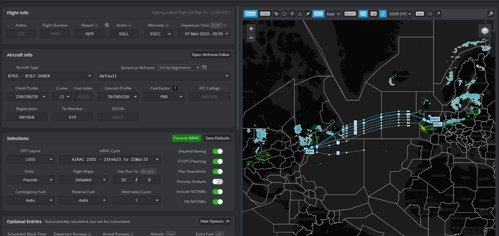
Head over to SimBrief.com and enter all flight and aircraft info. SB will automatically generate a route based on our paramaters given.
¶ Verifying NAT
Within the map viewr we can then toggle on NATs East and Significant weather overlays. SB also allows your to turn on wind-barb chart overlay for different FLs.
As we can see the proposed route matches with the expect active tracks for the time of flight.
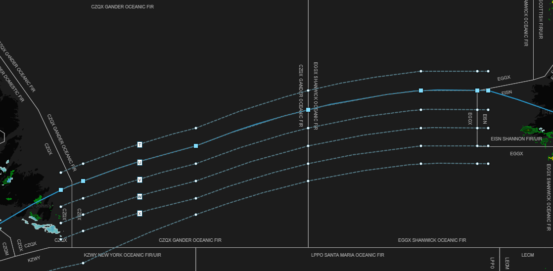
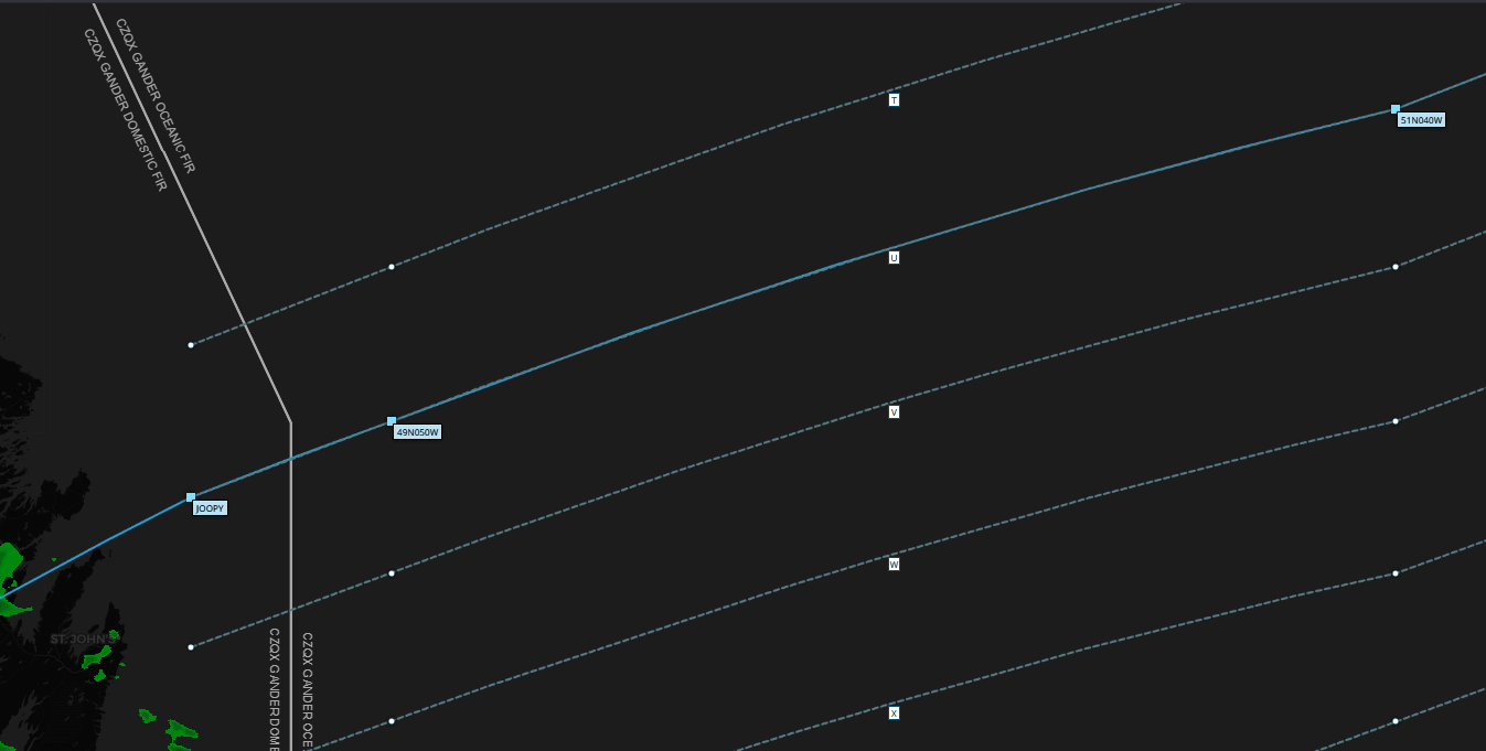
In this case we will plan on using track U with the OEP JOOPY
Note: It is important to generate your final OFP/Briefing just before the departure. NAT tracks change daily and you can end up filing for a NAT that is no longer in use from the time you did your FP briefing. Simbrief does not accurately provide the correct NAT for the appropriate time of day in the future.
Let's bring up Track U and see what it tells us:
U JOOPY 49/50 51/40 53/30 54/20 DOGAL BEXET
EAST LVLS 340 350 360 370 380 390 400
WEST LVLS NIL
EUR RTS EAST NIL
NAR N269A N263A N261A
We can now see the full oceanic route of track U as well as all available FLs (340-400)
¶ Custom Route
What if we prefer not to fly a specific NAT but rather a more efficient direct route?
In this case we will need to insert the oceanic coordinates as actual route waypoints since we are no longer using the Oragnized Tracks. This is then considered Random Routing.
SimBrief usually does a good job determining if a proposed route can use the NATs or random route.
¶ Generating FlightPlan
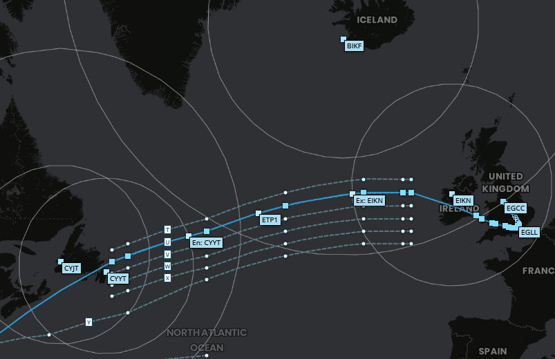
Once we are happy we can proceed to generate the OFP. SimBrief will the present us with the final route. By default the map viewer will also show us our ETOPS alternate airports.
In our case:
- CYJT and CYYT in Canada.
- BIKF in Iceland.
- EIKN in Ireland.
¶ Prefile
Final step is to select Prefile on Network and choose IVAO. This will lead us to fpl.ivao.aero with our entire FP pre-filled, now we simply click Submit FPL.
¶ OCEANIC CLEARANCE
¶ Discontinuity
Since March 2024 Oceanic Clearances are no longer required in the NAT Region (Shanwick, Gander, Santa Maria, NY). Aircraft may enter as filed/cleared.
So, what should be done then? Not much! Expect a normal hand off from Domestic ATC. Otherwise simply call the OCC controller when you reach their sector as shown here.
¶ ENTERING NAT REGION
On initial contact pilots only need to transmit the following information:
- callsign
- flight-level
- mach number
- SELCAL code
ATC will acknowledge and send a SELCAL check (if provided). Watch how it's done.
Phraseology example:
Pilot: Shanwick Radio, American 123, flight level 340, mach 0.85, selcal AB-CD.
ATC: American 123, roger, standby for selcal check AB-CD.
Pilot: Positive selcal check, American 123.
ATC: Roger, remain on selcal watch, no further position reporting required.
No further communications are done after this typically. All aircraft parameters are send to ATC units automatically (speed, flight level, waypoints, times, etc.)
¶ Position Reporting (Automated)
Since March 2024 manual position reporting is no longer required. IVAO now simulates automated position reporting between aircraft and ATC units every 5-10 seconds (180 seconds max.)
¶ Speed and Level Changes
It is a common request. You can by all means ask for a step-climb or speed change. To get a step climb there needs to be at least a window of 15 minutes on the crossing levels to allow for it. It is therefore wise to climb as high as possible before oceanic entry, it is less fuel-burning to fly above your optimum for a while than below it. That way you can make another step climb at the end of the Atlantic crossing to compensate for it.
Phraseology example:
Pilot: "Speedbird 172, Request FL370"
ATC: "Speedbird 172, Climb FL370, report reaching."
Pilot: "At FL370"
¶ Changing Frequency at 30°W
Passing 40°W going eastbound or 20°W going westbound, if there is more than one controller, you will be instructed to switch to Shanwick or Gander Radio respectively.
Remember, you need to remain on the current frequency until you reach30°W; then you may change to the next frequency.
¶ Leaving the track
When you pass 20°W going eastbound or 50°W going westbound ATC will pass you information on which controller to contact next. When you contact that controller, you will be given a squawk by deomstic ATC and you continue on your merry way.
¶ RANDOM ROUTING
Since March 2024 Oceanic Clearances are no longer required in the NAT Region (Shanwick, Gander, Santa Maria, NY). Aircraft may enter as filed/cleared.
¶ What is a random routing?
A random route is a flight plan route not using any active NAT.
We must observe but a few rules:
- At a minimum of every 10 degrees of longitude, a fix must be inserted into the flight plan.
- If flying into Santa Maria OCA or New York OCA (Caribbean flights) a fix should be made on the FIR boundary at 45°N or 44°N as that is the boundary between Shanwick to Santa Maria and Gander to New York respectively.
¶ Planning Random Route
- Similar as to the NAT, you need to indicate a Mach Number and a flight level.
- Waypoint format in the route is ddNdddW, this means that 46 North 15 West becomes 46N015W.
- Changes of speed or flight level need to be formatted /MxxxFxxx , replacing the Xs with the numbers
The correct routing portion for the Oceanic airspace should look like this (example):
… SEPAL DCT 46N015W 45N020W/M082F360 41N030W 36N040W/M082F380 29N050W DCT RKDIA/N0472F380 …